Introduction
Have you ever wondered how birds like the Siberian Crane travel so far and still return to the same place? Or how do we find our way in a new place like a zoo or bird sanctuary? Just like road signs guide us, maps and directions help us reach our destination. In this chapter, you will learn how to find directions using the sun or a compass, read and draw maps, follow routes, guide an ant through a maze, and use coordinates to locate animals in a zoo. With fun puzzles and activities, you’ll become a map master and explore anywhere with ease!
Finding Directions: Face the Rising Sun!
Do you know one simple way to find directions without using a compass? Let’s try this fun activity together!
Steps to be followed:
1. Go outside early in the morning or imagine you are standing in a field.
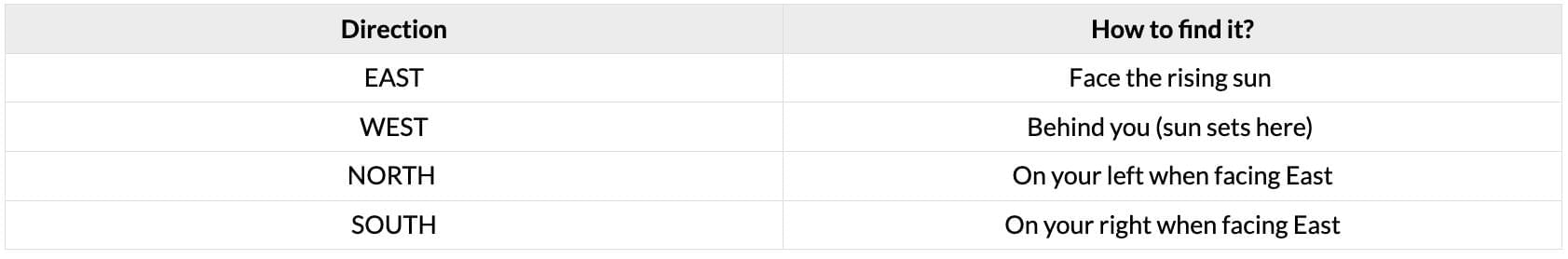
2. Now, face the rising sun. The direction you are facing is called East. The sun always rises in the East!
3. Stretch out your arms to your sides.
- Your left hand is now pointing towards the North.
- Your right hand is pointing towards the South.
- And the direction behind you is West – that’s where the sun sets.
You’ve just found all four cardinal directions — East, West, North, and South — just by facing the sun! Isn’t that cool?
Remember:
Let us perform some activities to understand directions better:
1. Observe the picture above and answer the following:
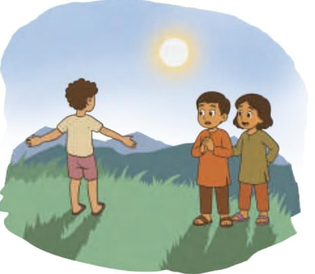
Manu is facing the rising Sun. That direction is East. His left hand is pointing in the North direction. His right hand is pointing in the South direction. West is behind him.
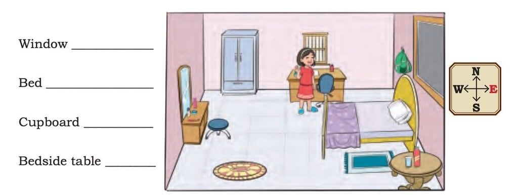
2. Write the directions of the following with the girl.
Ans:
Window — North
Bed — East
Cupboard — West
Bedside table — South
Let’s Learn About Maps!
Have you ever used a map while going on a trip or playing a treasure hunt game?
A map is a special drawing that shows the layout of places – like streets, parks, schools, or even a zoo! Maps help us find places, plan routes, and know which direction to go.
What Does a Map Show?
- Places – Like houses, roads, parks, shops, or famous monuments
- Symbols – Small pictures or signs that stand for things
- Directions – Maps usually have a direction arrow showing North (N), so we can figure out East, West, and South too
- Routes – Lines or paths that show how to go from one place to another
- Key or Legend – A box that explains what the symbols on the map mean
Now, Let’s Use a Map!
1. The street map shows the bus route with dotted lines. The bus will pick up children from Stop 1 and Stop 2 marked on the map.
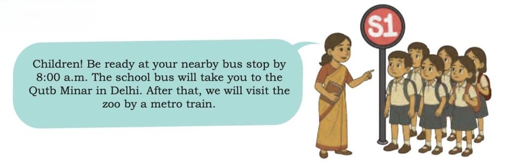
Observe the map and help the children board the bus.
The bus will start from the parking area. It will go north and then it will take a right turn onto ___________ Road driving in the ___________ direction to reach Stop 1(S1). To reach Stop 2(S2), it will turn _______ (right/left) onto ___________ Road driving in the ___________ direction.
Ans: The bus will start from the parking area. It will go north and then it will take a right turn onto Market Road driving in the east direction to reach Stop 1 (S1). To reach Stop 2 (S2), it will turn left onto Temple Road driving in the north direction.
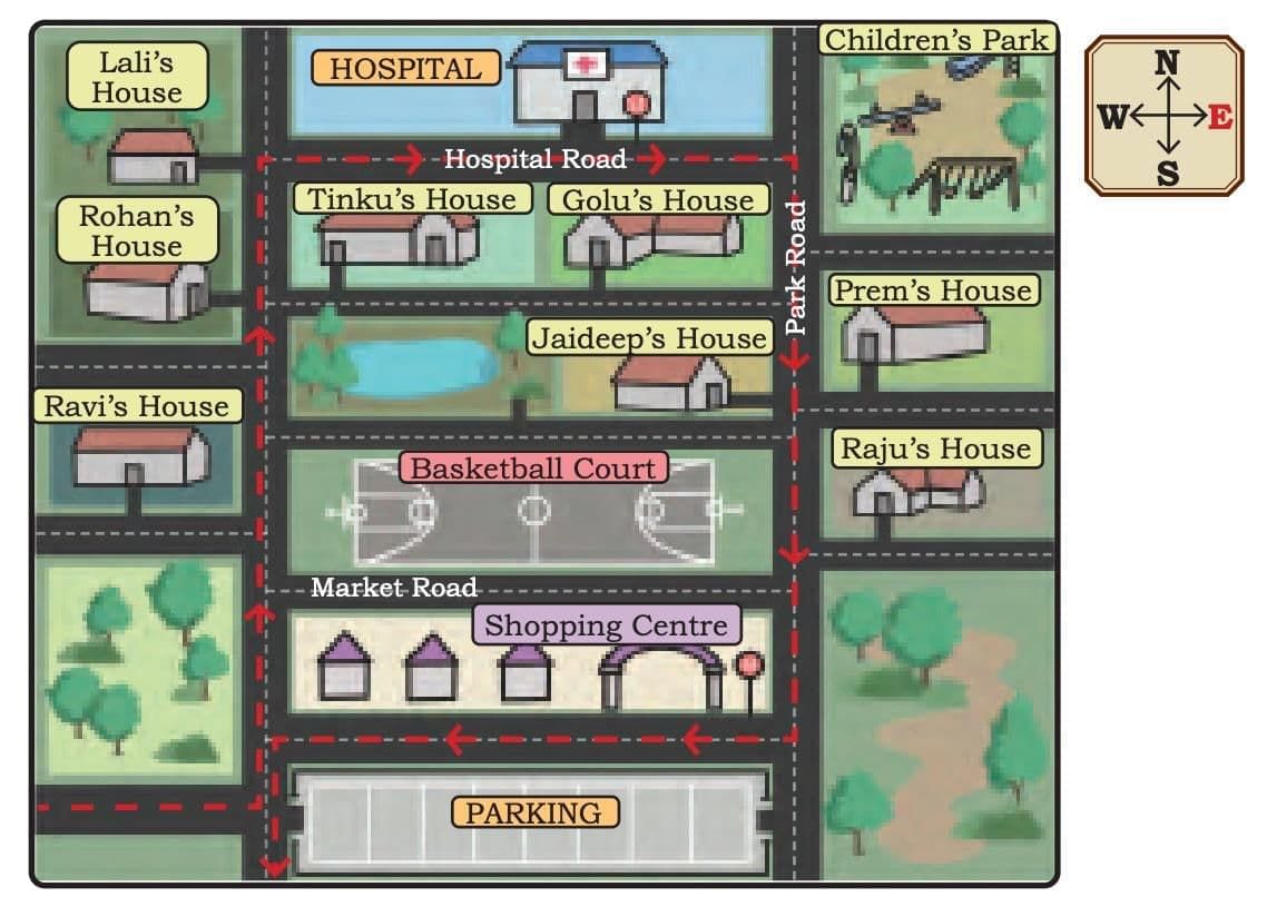
Bus Route
(a) Whose houses are situated to the east of Jaideep’s house?____________
(b) Mark the route from Ravi’s house to the children’s park.
(c) Which stop is closer to Lali’s house? __________________
(d) Golu is running late. Trace the route to help him reach the nearest bus stop.
(e) In which direction would Prem have to move to reach Stop 2?
Ans:
(a) Raju’s house and Prem’s house
(b) From Ravi’s house → go north on Hospital Road → turn east to reach Children’s Park
(c) Stop 1 (S1)
(d) From Golu’s house → go north on Market Road → turn east to reach Stop 1 (S1)
(e) North
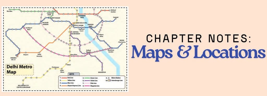
2. Children will get off the bus at the Qutub Minar metro station. To reach the zoo, they need to get off the metro at the Supreme Court metro station. Here is the metro map for your reference. Read the key to the symbols and identify them on the map. What do the different coloured lines represent? Mark the Qutub Minar station on the Yellow Line and the Supreme Court station on the Blue Line.
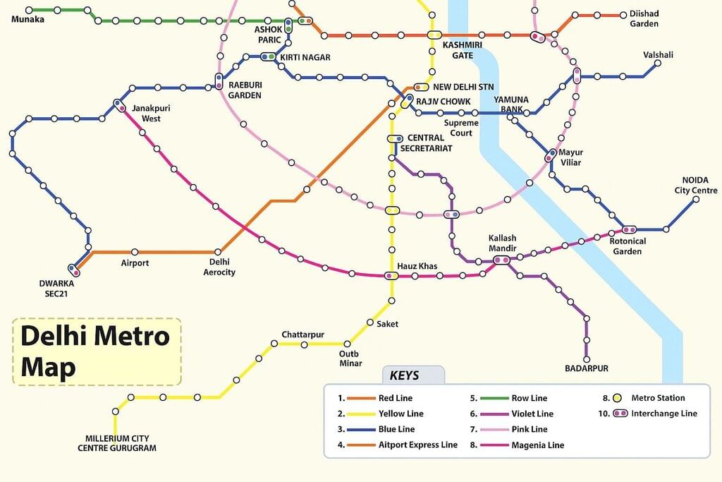
Study the map carefully and answer the questions that follow.
(a) Look at the metro map and trace different routes from the Qutub Minar metro station to the Supreme Court metro station.
(b) Lali says, “We can take the Yellow Line and change the metro at Hauz Khas to take the Magenta Line.” If the children follow Lali’s suggestion, at which station(s) do they need to change the metro line again to reach the Supreme Court metro station?
(c) Which route has the least number of stations between Qutub Minar and the Supreme Court?
(d) Which metro route(s) do you think, is/are the best way to reach the zoo from Qutub Minar? __________________________
Ans:
(a) Possible routes from Qutub Minar (Yellow Line) to Supreme Court (Blue Line):
- Route 1:
Qutub Minar (Yellow) → Central Secretariat (Interchange) → Supreme Court (Blue) - Route 2 (via Rajiv Chowk):
Qutub Minar (Yellow) → Rajiv Chowk (Interchange) → Supreme Court (Blue) - Route 3 (via Hauz Khas & Magenta Line):
Qutub Minar (Yellow) → Hauz Khas (Interchange to Magenta) → Janakpuri West (Interchange to Blue) → Supreme Court
(b) If Lali’s suggestion is followed:
- First change: Hauz Khas (Yellow → Magenta)
- Second change: Janakpuri West (Magenta → Blue)
(c) The shortest route (fewest stations):
- Qutub Minar → Central Secretariat → Supreme Court (only 1 change)
(d) Best route:
- Qutub Minar (Yellow) → Central Secretariat (Change to Blue) → Supreme Court
- Reason: This is the shortest, simplest route with only one interchange and minimal travel time.
Now that we have understood the concept of maps and directions, let us solve some questions:
1. To collect food, the ant can only crawl along the dotted lines on the grid. The arrows show the direction in which the ant can move.

Fill in the blanks below with the distances and the directions in which the ant must move from its starting position.
(a) To get to the laddoos, the ant has to crawl 2 cm towards the east.
(b) To get to the sugar, the ant has to crawl ____cm in the _______direction.
(c) To get to the bread, the ant has to crawl ____cm in the _______ direction; then ____cm in the _______direction.
(d) To get to the apple, the ant needs to crawl ______ cm towards _________, and then ____cm towards _________, and finally ___cm towards______.
Identify other routes to reach the point where Apple is located. Which one is the shortest?
2. Locating the Animals in the Zoological Park (Zoo)
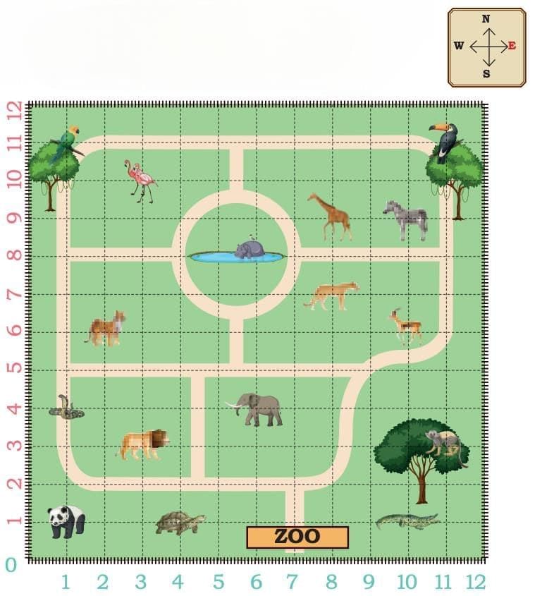
Children observe a map of the zoo drawn on a grid. Each vertical line (column) and horizontal line(row) is marked with a number. To reach the Panda, we will start from zero. Move one step horizontally east and reach the first column. Move up (vertically) one step north and reach the first row. The panda is where the first row and the first column meet.
We write the meeting point of the first row and the first column as (1,1).
To reach the tortoise, move ________ steps towards east and reach the_________ column.
Then move _______ step(s) _______ and reach the first _______.
The location of the tortoise is (4,1). What is at (1,4)?
Answer the following questions now:
1. Locate the animal at the following positions on the map.
(a) (11,11) ________
(b) (2,6) ________
(c) (6,4) ________
(d) (3,10) ________
(e) (11,3) ________
(f) (10,9) ________
2. Write the position of the following animals on the map.
(a) Lion _________
(b) Elephant ____
(c) Tortoise ________
(d) Deer _________
(e) Panda _________
(f) Crocodile ______
3. Place dots of different colours in the following positions.
(a) (8,3) (Red)
(b) (2,9) (Green)
(c) (7,3) (Blue)
(d) (3,8 (Orange)
(e) (8,6) (Black)
(f) (6, 6) (Pink)
Conclusion
Now you know how to find your way using directions, read maps, follow routes, and even use grids to locate places or animals. Maps are like secret guides that help us travel and explore without getting lost. So, whether you are going to a park, a zoo, or even a new friend’s house, you can be a smart explorer and find your way easily!