06. Population – Textbook Solutions

Q1. Choose the right answer from the four alternatives given below.

(i) Migrations change the number, distribution and composition of the population in
(a) the area of departure 
(b) the area of arrival 
(c) both the area of departure and arrival 
(d) None of the above
Ans: (c) both the area of departure and arrival

Migrations affect both the area from which people leave (the area of departure) and the area where they move to (the area of arrival). In the area of departure, migration can lead to a decrease in population size and changes in the local demographic composition. In the area of arrival, migration can lead to an increase in population size and potentially alter the demographic makeup.

(ii) A large proportion of children in a population is a result of
(a) high birth rates
(b) high life expectancies
(c) high death rates
(d) more married couples
Ans: (a) high birth rates

A large proportion of children in a population typically results from high birth rates. High birth rates mean that more children are being born relative to the overall population, which increases the proportion of children.

(iii) The magnitude of population growth refers to:
(a) the total population of an area
(b) the number of persons added each year
(c) the rate at which the population increases
(d) the number of females per thousand males
Ans: (b) the number of persons added each year

The magnitude of population growth refers to the rate at which the population increases, which measures how quickly the number of people is growing over a period of time.

(iv) According to the Census, a “literate” person is one who
(a) can read and write his/her name
(b) can read and write any language
(c) is 7 years old and can read and write any language with understanding
(d) knows the 3 ‘R’s (reading, writing, arithmetic)
Ans: (c) is 7 years old and can read and write any language with understanding

According to the Census, a person is “literate” if they are at least 7 years old and can read and write in any language with understanding. This definition focuses on both the ability to read and write and the understand the written material.

Q2. Answer the following questions briefly.

(i) Why is the rate of population growth in India declining since 1981?

Ans: The rate of population growth in India has been declining since 1981, primarily due to a decrease in birth rates. This gradual decline can be attributed to various factors, including the implementation of effective family planning and birth control measures, increased awareness about the importance of smaller families, improvements in healthcare, and an overall shift in societal attitudes towards reproduction. These concerted efforts have played a significant role in reducing the rate of population growth in the country.


(ii) Discuss the major components of population growth.
Ans: The major components of population growth are:

  • Birth rate: It is the number of live births per thousand persons in a year. It is a major component of growth because in India, birth rates have always been higher than the death rates.
  • Death rate: It is the number of deaths per thousand persons in a year. The main cause of the rate of growth of the Indian population has been the rapid decline in the death rate.
  • Migration: Migration is the movement of people across regions and territories. Migration can be internal (within the country) or international (between countries).
  • The difference between birth rate and death rate accounts for a natural increase in population.
  • Immigration refers to the inflow of people into a region from other regions.


(iii) Define age structure, death rate and birth rate.
Ans: 

  • Age structure, or age distribution, shows how many people are in different age groups within a population. It helps us understand the number of children, working-age adults, and elderly people in that group.
  • Birth rate, often expressed as the crude birth rate, is the number of live births in a population during a specific time, usually a year. It is measured per 1,000 people, making it easy to compare population growth or decline across regions or time periods.
  • Death rate, or crude death rate, is the number of deaths in a population during a specific time, usually measured per 1,000 people. It helps track mortality trends, and when combined with the birth rate, shows how the population grows or shrinks, without considering migration.


(iv) How is migration a determinant factor of population change?
Ans:

  • Migration refers to the process of people moving from one region or territory to another.
  • This movement results in a shift in the population and demographics of both the departure and arrival areas.
  • Migration plays a significant role in population change, affecting the size and composition of populations.
  • Migration can be categorised into two primary types: internal and international.
  • Internal migration occurs within a country’s borders.
  • In contrast, international migration involves crossing national boundaries.


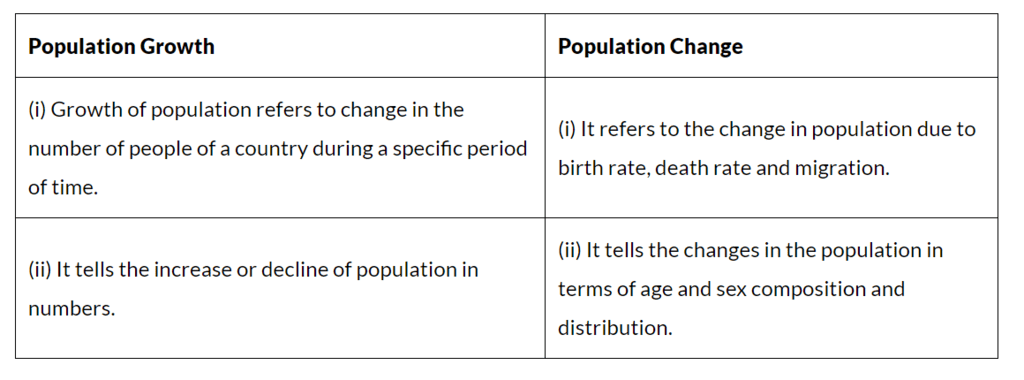
Q3. Distinguish between population growth and population change.
Ans: 


Q4. What is the relation between occupational structure and development?
Ans:

  • The distribution of the population according to different types of occupations is referred to as the occupational structure.
  • The occupational structure is classified into primary, secondary, and tertiary sectors.
  • The primary activities include agriculture, fishing, forestry, and mining.
  • The secondary activities include building and construction work.
  • The tertiary activities cover transport, communication, commerce, and administration.
  • The proportion of people engaged in different activities varies between developed and developing countries.
  • Developed nations have a high proportion of people in secondary and tertiary activities.
  • Developing countries have a higher proportion of the workforce engaged in primary activities.
  • In India, there has been a shift in favour of the secondary and tertiary sectors due to growing industrialisation and urbanisation.


Q5. What are the advantages of having a healthy population?
Ans:
 The advantages of having a healthy population are:

  • A healthy individual is much more efficient and productive than an unhealthy individual.
  • He or she can realise his or her potential and play an important role in social and national development.
  • Absenteeism is low when the workers are healthy.


Q6. What are the significant features of the National Population Policy 2000?
Ans: The significant features of the National Population Policy 2000 are as follows:

  • Imparting free and compulsory school education up to 14 years of age.
  • Reducing the infant mortality rate to below 30 per 1000 live births.
  • Achieving universal immunisation of children against all vaccine-preventable diseases.
  • Promoting delayed marriage and childbearing.
  • Making family welfare a people-centred programme.
  • Providing nutritional services and food supplements to adolescents.
  • Protecting adolescents from unwanted pregnancies and sexually transmitted diseases, and educating them about the risks of unprotected sex.
  • Making contraceptive services accessible and affordable.

05. Natural Vegetation and Wildlife – Textbook Solutions

Q1. Choose the right answer from the four alternatives given below:

(i) To which one of the following types of vegetation does rubber belong to?
(a) Tundra 
(b) Tidal
(c) Himalayan
(d) Tropical Evergreen
Ans: (d) Tropical Evergreen

Rubber trees are typically found in tropical evergreen forests. These forests are characterized by high rainfall and consistent temperatures throughout the year, which are ideal conditions for rubber cultivation.

(ii) Cinchona trees are found in the areas of rainfall more than
(a) 100 cm 
(b) 50 cm
(c) 70 cm
(d) less than 50 cm
Ans: (a) 100 cm

Cinchona trees, which are used for extracting quinine, thrive in areas with rainfall of more than 100 cm annually. They are typically found in tropical regions with abundant rainfall.

(iii) In which of the following state is the Simlipal bio-reserve located?
(a) Punjab 
(b) Delhi 
(c) Odisha 
(d) West Bengal

Ans: (c) Odisha

The Simlipal Biosphere Reserve is located in the state of Odisha. It is known for its rich biodiversity and is an important protected area in eastern India.

(iv) Which one of the following bio-reserves of India is not included in the world network of bioreserve?
(a) Manas 
(b) Nilgiri
(c) Gulf of Mannar
(d) Panna

Ans: (d) Panna

The Panna Biosphere Reserve is not included in the World Network of Biosphere Reserves. However, the NilgiriGulf of Mannar, and Manas are part of this network.

Q2. Answer the following questions briefly.

(i) What is a bio-reserve? Give two examples.
Ans: Bio-reserves are the large areas where vegetation, wildlife and the environment are conserved to preserve the biological diversity. In totality, there are 18 bio-reserves in India. Examples include Sunderbans Bio-reserve in West Bengal and Nanda Devi Bio-reserve in Uttaranchal.


(ii) Name two animals having habitat in tropical and montane type of vegetation.
Ans: The common animals found in the tropical forests are elephants and monkeys and the common animals found in the montane forests are Kashmir stag and spotted deer.

Q3. Distinguish between
(i) Flora and Fauna
Ans: The word ‘flora’ is used to denote plants of a particular region or period and the species of animals are referred to as ‘fauna’.

Flora and Fauna: Comparison

(ii) Tropical Evergreen and Deciduous Forests
Ans: Tropical Evergreen Forests:

  • Rainfall is very heavy, over 200 cm of rain.
  • Forests appear green all year round as the trees shed their leaves at different times of the year.
  • Vegetation is luxuriant, multilayered, and of great variety.
  • Commercially important trees are ebony, mahogany, rosewood, rubber, and cinchona.

Deciduous Forests:

  • They are also known as Monsoon Forests.
  • These are found where the rainfall is between 70 cm – 200 cm.
  • Trees shed their leaves for about 6-8 weeks in the dry summer.
  • These forests are divided into Dry and Wet Deciduous Forests.

Q4. Name different types of vegetation found in India and describe the vegetation of high altitudes.
Ans: The different types of vegetation found in India are:

  • Tropical Evergreen Forests
  • Tropical Deciduous Forests
  • Tropical Thorn Forests and Scrubs
  • Mangrove Forests

In mountainous areas, the decrease in temperature with increasing altitude leads to the corresponding change in natural vegetation:

  • The foothills of the Himalayas, Shiwaliks, have tropical moist deciduous flora. Sal and bamboo are important trees.
  • They are followed by the wet hill forests. They lie between about 1,000 to 2,000 m. Important trees are oak, chestnut, ash, birch, etc.
  • Between 1,500 and 3,300 m above sea level, there occur the well-known coniferous forests. Pine, deodar, silver fir, spruce, etc., are some dominant trees.
  • Above the coniferous forests lie the alpine forests at an altitude of about 3,600 m. Important trees are silver fir, pine, birch, etc. Alpine vegetation is found at places over 3,600 m in height. The trees common to these are silver fir, junipers, pines, and birches. 

Q5. Quite a few species of plants and animals are endangered in India. Why?
Ans:
 Many plants and animals are endangered in India due to a number of reasons:

  • Hunting of animals for commercial purposes.
  • Pollution due to chemical and industrial waste, and acid deposits.
  • Introduction of alien species.
  • Reckless cutting of the forests to bring land under cultivation and inhabitation.

As a result of these activities about 1300 plant species are endangered and 20 plant species have become extinct. Quite a few animal species are also endangered.

Q6. Why has India a rich heritage of flora and fauna?
Ans: India has a rich heritage of flora and fauna due to the following reasons:

  • India is a diverse country with various relief features (i.e. mountains, plateaus, plains, etc.) These regions consist of different types of vegetation that support different types of animals.
  • There is the availability of different types of soil which facilitates a base for different types of vegetation.
  • There is variation in the climatic conditions of India (Temperature, humidity, etc.). It differs from north to south and east to west. Thus, supporting a large variety of flora and fauna.
  • India has a monsoon type of climate where rainfall varies from 20 cm to 300 cm distributed throughout the year, supporting a large amount of flora and fauna.
  • Variation in the duration of sunlight at different places due to differences in latitude and altitude.

Map Skills

Q. On an outline map of India, label the following.
(i) Areas of Evergreen Forests 
(ii) Areas of Dry Deciduous Forests 
(iii) Two national parks each in Northern, Southern, Eastern and Western parts of the Country
Ans: The outline of India’s map is given below with the labelling of the above-mentioned areas.

04. Climate – Textbook Solutions

Q1. Choose the correct answer from the four alternatives given below.

(i) Which one of the following places receives the highest rainfall in the world?
(a) Silchar 
(b) Mawsynram 
(c) Cherrapunji 
(d) Guwahati
Ans: (b) Mawsynram

Mawsynram, located in the state of Meghalaya, India, is known for receiving the highest rainfall in the world.


(ii) The wind blowing in the northern plains in summers is known as:
(a) Kaal Baisakhi 
(b) Loo 
(c) Trade Winds 
(d) None of the above
Ans: (b) Loo

The Loo is a hot, dry wind blowing across the northern plains of India during the summer months

(iii) Monsoon arrives in India approximately in:
(a) Early May
(b) Early July
(c) Early June
(d) Early August
Ans:
 (c) Early June

Monsoon generally arrives in India around early June, bringing much-needed rain to various parts of the country.

(iv) Which one of the following characterises the cold-weather season in India?
(a) Warm days and warm nights
(b) Warm days and cold nights
(c) Cool days and cold nights
(d) Cold days and warm nights
Ans:
 (b) Warm days and cold nights

The cold-weather season is characterized by warm days and cold nights, as daytime temperatures are more comfortable compared to the significantly colder nighttime temperatures.


Q2. Answer the following questions briefly.

(i) What are the controls affecting the climate of India?
Ans: The climate of India is influenced by six main factors:

  • Latitude: The Tropic of Cancer runs through India, dividing it into tropical and subtropical regions. This affects the overall climate.
  • Altitude: The northern mountains, averaging 6,000 meters, block cold winds from Central Asia, resulting in milder winters.
  • Pressure and Winds: Weather patterns are shaped by atmospheric pressure, surface winds, and upper air circulation, including cyclonic disturbances.
  • Distance from the Sea: Coastal areas experience moderated climates, while areas further inland face extreme temperatures
  • Ocean Currents: These currents, along with onshore winds, significantly impact coastal climates, warming or cooling them based on the current’s temperature.
  • Relief Features: Mountains can block winds and create rain shadows, leading to dry areas on the leeward side.

(ii) Why does India have a monsoon type of climate?
Ans: 
India has a monsoon type of climate due to the influence of monsoon winds, which primarily operate between 20° North and 20° South.

  • The climate is characterised by distinct seasonal changes.
  • It features both tropical and subtropical characteristics.
  • Mountain ranges, like the Himalayas, block cold winds from Central Asia, resulting in milder winters.
  • Weather patterns are influenced by: Pressure and surface winds, Upper air circulation, Western cyclonic disturbances and tropical cyclones.

(iii) Which part of India does experience the highest diurnal range of temperature and why?
Ans:  The Indian desert, located in the north-western part of India, experiences the highest diurnal range of temperature. This is due to the following reasons:

  • The sand in the desert heats up quickly during the day.
  • At night, the sand cools down rapidly.
  • For example, daytime temperatures can reach up to 50°C, while nighttime temperatures may drop to around 15°C.

(iv) Which winds account for rainfall along the Malabar Coast?
Ans: Malabar Coast gets rains from South-West Monsoon Winds.

(v) Define monsoons. What do you understand by “break” in monsoon?
Ans:  
Monsoons are a significant wind system that affects large climatic areas, reversing direction with the seasons. They are characterized by:

  • Seasonal Changes: Monsoons bring distinct wet and dry periods, particularly during the rainy season.
  • Breaks in Rainfall: The term “break” refers to intervals of dry weather amidst the rainy season, where rainfall occurs only for a few days at a time.
  • Monsoon Trough Movement: The position of the monsoon trough influences rainfall distribution. When it is over the plains, rainfall is abundant; when it shifts towards the Himalayas, dry spells occur in the plains.
  • Impact on Regions: Heavy rains can lead to significant downpours in mountainous areas, while plains may experience prolonged dry periods.

(vi) Why is the monsoon considered a unifying bond?
Ans: The monsoon is considered a unifying bond because:

  • The monsoon of India is highly influenced by its flora and fauna.
  • These monsoon winds provide the water for agricultural activities.
  • Most of the festivals in India that are related to the agricultural cycle may be known by different names in different parts of the country, but the monsoon decides their celebration.
  • The river valleys which carry this water also unite as a single river valley unit.

Q3. Why does the rainfall decrease from the east to the west in Northern India?
Ans: The rainfall decreases from the east to the west in Northern India because of the following reason:

  • The low-pressure area in India lies in the northwest, towards which the South West Monsoon winds are attracted.
  • After depositing moisture in south India, the Bay of Bengal branch of the South West Monsoons strikes the Khasi-Garo Hills.
  • After causing heavy rainfall on the windward slopes, these winds turn westwards because of the presence of the lofty Himalayas. 
  • These winds then keep depositing rainfall, they go up the Ganga Valley towards the low-pressure area. 


Q4. Give reasons as to why.

(i) Seasonal reversal of wind direction takes place over the Indian subcontinent?
Ans: Seasonal reversal of wind direction over the Indian subcontinent takes place due to pressure differential. El Nino has major role to play in the seasonal reversal of wind direction over the Indian subcontinent.


(ii) The bulk of rainfall in India is concentrated over a few months.
Ans: The monsoon begins from the first week of June and advances quite rapidly to cover almost the whole country by mid-July. Hence, the bulk of rainfall in India concentrated over the months of a few months; mainly June to August.


(iii) The Tamil Nadu coast receives winter rainfall.
Ans: The Tami Nadu coast receives winter rainfall because of movement of low-pressure conditions to the Bay of Bengal.


(iv) The delta region of the eastern coast is frequently struck by cyclones.
Ans: The Bay of Bengal is the centre of various pressure changes and hence there is always a chance of development of cyclone. Due to this, the delta region of the eastern coast is frequently struck by cyclones.

(v) Parts of Rajasthan, Gujarat and the leeward side of the Western Ghats are drought-prone.
Ans: Mountains play an important role in the distribution of rainfall in India. The moisture-laden winds (South West Monsoons) cause heavy rain on the windward slopes of the Western Ghats and Khasi-Garo hills. When winds cross over mountains, they lose most of their moisture on the windward side (the side facing the wind), resulting in less rainfall on the leeward side (the side sheltered from the wind). This dry area on the leeward side, which gets very little rain, is often drought-prone. Rajasthan is an example of such a region; it lies in the rain shadow of the Aravalli Hills, meaning it receives significantly less rainfall compared to areas on the windward side of the hills.


Q5. Describe the regional variations in the climatic conditions of India with the help of suitable examples.
Ans: There is regional variation in the climatic conditions of India. Temperature and Precipitation vary from place to place and season to season. 

  • During the summer season, the temperature rises up to 50°C in parts of Rajasthan, whereas it may be around 20°C in Pahalgam in Kashmir.
  • During the winter season at night, the temperature in Drass in Kashmir may be minus 45°C, whereas in Thiruvananthapuram in Kerala may have a temperature of 20°C.
  • In the Andaman Islands, the difference between the temperatures of day and night may be hardly 7° – 8°C.
  • Most parts of India receive rainfall from June – September, whereas some parts like the Tamil Nadu coast get a large portion of its rain during October and November.


Q6. Give an account of weather conditions and characteristics of the cold season.
Ans:  The cold weather season in northern India has several distinct features:

  • Duration: It starts in mid-November and lasts until February.
  • Coldest Months: December and January are the coldest.
  • Temperature: In the northern plains, temperatures range from 10°C to 15°C, while in Chennai, it is warmer at 24°C to 25°C.
  • Day and Night: Days are generally warm, but nights can be quite cold.
  • Winter Rainfall: Known locally as mahawat, this rainfall is crucial for the rabi crop, despite being small in quantity.


Q7. Give the characteristics and effects of the monsoon rainfall in India.
Ans: Characteristics of the monsoon rainfall in India:

  • The duration of the monsoon varies from 100 to 120 days from early June to mid-September.
  • The normal rainfall suddenly increases, around the time of its arrival and continues regularly for several days. This is called the ‘burst’ of the monsoon.
  • The monsoon arrives at the southern tip of the Indian Peninsular generally by the first week of June.

Effects of the monsoon rainfall in India:

  • Agriculture in India largely depends on Indian monsoons for water. Late, Low, or excessive rains have a negative impact on crops.
  • Due to the uneven distribution of rainfall across the country, there are few places that are drought-prone and few are flood-affected.
  • The monsoon provides India with a diverse climatic pattern. Hence, despite the presence of great regional variations, it has a unifying influence on the country and its people.


Map Skills

Q. On an outline map of India, show the following.
(i) Areas receiving rainfall over 400 cm.
(ii) Areas receiving less than 20 cm of rainfall.
(iii) The direction of the southwest monsoon over India.
Ans:

(i) The Western Coast and North Eastern India receive rainfall over 400 cm. Mawsynram and Cherrapunji in Meghalaya are known for receiving maximum rainfall in the world. The Andaman Islands and Lakshadweep Islands are also known to receive annual rainfall above 400 cm.
(ii) The parts of Northern Kashmir, Western Rajasthan, Deccan Plateau and Punjab are known to be the areas that receive scanty rainfall that is less than 20 cm. In the Northern part of India, rainfall decreases toward the west, while in the peninsular region except for Tamil Nadu, the rainfall decreases eastwards.
(iii) In early June, a low-pressure area over northern India attracts southeast trade winds from the southern hemisphere. These winds blow southwesterly into India, bringing moisture and abundant rainfall. Moving at about 30 km per hour, the southwest monsoon signals the start of the rainy season, transforming the weather across the country.

03. Drainage – Textbook Solutions

Q1. Choose the right answer from the four alternatives given below.

(i) In which of the following states is the Wular Lake located?

(a) Rajasthan
(b) Uttar Pradesh
(c) Punjab
(d) Jammu and Kashmir
Ans:
 (d) Jammu and Kashmir state.

Wular lake is the largest freshwater lake in India and is situated in the Bandipora district of Jammu and Kashmir. The lake is surrounded by beautiful mountains and serves as an important habitat for various species of migratory birds.

Wular Lake

(ii) The river Narmada has its source at
(a) Satpura
(b) Brahmagiri
(c) Amarkantak
(d) Slopes of the Western Ghats
Ans:
 (c) Amarkantak

Amarkantak is a pilgrimage site and a hill station located at the meeting point of the Vindhya and Satpura mountain ranges. Narmada is one of the longest rivers in India, spanning a length of approximately 1,312 kilometers. It is often referred to as the “lifeline of Madhya Pradesh” and is considered sacred by Hindus.

(iii) Which one of the following lakes is a salt water lake?
(a) Sambhar
(b) Dal 
(c) Wular  
(d) Gobind Sagar
Ans:
 (a) Sambhar

Sambhar Lake, located in the state of Rajasthan, India, is a saltwater lake. It is the largest inland saltwater lake in India and serves as a major source of salt production in the country. 

(iv) Which one of the following is the longest river of the Peninsular India?
(a) Narmada
(b) Krishna
(c) Godavari
(d) Mahanadi
Ans:
 (c) Godavari

The Godavari River originates in the Western Ghats of Maharashtra and flows through the states of Maharashtra, Telangana, Andhra Pradesh, and eventually empties into the Bay of Bengal. The river stretches for about 1,465 kilometers (910 miles) in length, making it the longest river in Peninsular India. 

(v) Which one amongst the following rivers flows through a rift valley?
(a) Mahanadi
(b) Tungabhadra
(c) Krishna
(d) Tapi
Ans:
 (d) Tapi

A rift valley is a long, narrow valley that is formed by the sinking and separation of the Earth’s crust. The Tapi River originates in the Betul district of Madhya Pradesh and flows through Maharashtra and Gujarat before draining into the Arabian Sea.


Q2. Answer the following questions briefly.

(i) What is meant by a water divide? Give an example.
Ans: water divide is an elevated area, like a mountain or upland, that separates two drainage basins. This means that water on either side flows into different rivers or lakes. For example, the water divide between the Indus and Ganga river systems is located at Ambala.


(ii) Which is the largest river basin in India?
Ans: The Ganga River basin is the largest in India. Key details include:

  • It spans over 2,500 km.
  • It covers several states, including UttarakhandUttar PradeshBihar, and West Bengal.


(iii) Where do the rivers Indus and Ganga have their origin?
Ans: 
The Indus originates in Tibet, near Mansarovar Lake. The Ganga River originates at the Gangotri Glacier, Uttarakhand on the southern slopes of the Himalayas.

(iv) Name the two headstreams of the Ganga. Where do they meet to form the Ganga?
Ans: The two headstreams of the Ganga are the Bhagirathi and the Alaknanda. They meet to form the Ganga at Devaprayag in Uttarakhand.


(v) Why does the Brahmaputra in its Tibetan part have less silt, despite a longer course?
Ans: The Brahmaputra River in its Tibetan region has a smaller volume of water and less silt due to the cold and dry climate. As the river flows into Arunachal Pradesh, India, it encounters high levels of rainfall and increased water and silt content.


(vi) Which two Peninsular rivers flow through trough?
Ans: The Narmada and the Tapi are the two peninsular rivers that flow through the trough.


(vii) State some economic benefits of rivers and lakes.
Ans: 

Economic benefits of rivers:

  • Rivers provide water, which is a basic natural resource for various human activities.
  • They are used for irrigation, navigation and generation of hydroelectric power.
  • They have a moderating influence on the climate of the surroundings and maintain the aquatic ecosystem.

Economic benefits of lakes:

  • They help to regulate the flow of a river.
  • They prevent flooding at times of heavy rainfall and during the dry season, they help to maintain an even flow of water.
  • They also have a moderating influence on the surrounding climatic conditions and maintain the aquatic ecosystem.
  • They enhance natural beauty and recreational activities by encouraging tourism.
  • Lakes are also used for the generation of hydroelectricity.


Q3. Below are given names of a few lakes of India. Group them under two categories − natural and created by human beings.
(a) Wular
(b) Dal
(c) Nainital
(d) Bhimtal
(e) Gobind Sagar
(f) Loktak
(g) Barapani
(h) Chilika
(i) Sambhar
(j) Rana Pratap Sagar
(k) Nizam Sagar
(l) Pulicat
(m) Nagarjuna Sagar
(n) Hirakund
Ans: Natural Lakes
(a) Wular
(b) Dal
(c) Nainital
(d) Bhimtal
(f) Loktak
(g) Barapani
(h) Chilika
(i) Sambhar
(l) Pulicat
Lakes created by human beings
(e) Gobind Sagar
(j) Rana Pratap Sagar
(k) Nizam Sagar
(m) Nagarjuna Sagar
(n) Hirakund

Q4. Discuss the significant difference between the Himalayan and the Peninsular rivers.
Ans: 

Q5. Compare the east-flowing and the west-flowing rivers of the Peninsular Plateau.
Ans:

Q6. Why are rivers important for the country’s economy?
Ans: Rivers play a vital role in a country’s economy for several reasons:

  • They are a key source of freshwater, essential for the survival of humans and wildlife.
  • River water is used for domestic, industrial, and agricultural purposes.
  • They facilitate trade and commerce by enabling the transport of goods.
  • Rivers are potential sources of energy, particularly for hydroelectric power.
  • They support navigation and transport, which are crucial for commercial activities.
  • Rivers provide fishing opportunities and enhance scenic beauty, making them attractive for tourism.

Map skills

Q. (i) On the outline map of India mark and label the following rivers: Ganga, Satluj, Damodar, Krishna, Narmada, Tapi, Mahanadi, and the Brahmaputra.
(ii) On an outline map of India mark and label the following lakes: Chilika, Sambhar, Wular, Pulicat, Kolleru 

Ans: 

A water divide is an elevated area, like a mountain or upland, that separates two drainage basins. This means that water on either side flows into different rivers or lakes. For example, the water divide between the Indus and Ganga river systems is located at Ambala.

02. Physical Features of India – Textbook Solutions

Q1. Choose the right answer from the four alternatives given below.

(i) A landmass bounded by the sea on three sides is referred to as

(a) Coast
(b) Island
(c) Peninsula
(d) None of the above
Ans:
 (c) Peninsula

Peninsulas are typically surrounded by water on three sides, with the fourth side connected to a larger landmass. They can vary in size and shape. Some famous examples of peninsulas include the Iberian Peninsula (Spain and Portugal), the Italian Peninsula, and the Malay Peninsula.

A Peninsula

(ii) Mountain ranges in the eastern part of India forming its boundary with Myanmar are collectively called
(a) Himachal
(b) Uttarakhand
(c) Purvachal
(d) None of the above
Ans:
 (c) Purvachal

Purvachal is home to several mountain ranges, including the Patkai, Naga Hills, and Manipur Hills. These mountain ranges play a significant role in shaping the topography of the region and act as a natural boundary between India and Myanmar.

(iii) The western coastal strip, south of Goa is referred to as
(a) Coromandel
(b) Konkan
(c) Kannad
(d) Northern Circar
Ans:
 (c) Kannad

The Kannad Plain, also known as the Karnataka Coastal Plain or Kanara Plain, is the central section of the Western Coastal Plains in India. It stretches from Goa in the north to Mangalore in the south, along the Arabian Sea coast.

(iv) The highest peak in the Eastern Ghats is
(a) Anai Mudi
(b) Kanchenjunga
(c) Mahendragiri
(d) Khasi
Ans:
 (c) Mahendragiri

Mahendragiri is located in the Paralakhemundi region of the Gajapati district in Odisha, India. It stands at an elevation of approximately 1,501 meters (4,925 feet) above sea level.

Q2. Answer the following questions briefly.

(i) What is the bhabar?
Ans:
 Bhabar is a narrow belt containing pebbles instead of silt along the banks of the upper Himalayan rivers from the Indus River to the Teesta River.

(ii) Name the three major divisions of the Himalayas from north to south.
Ans:

(a) The Greater Himalayas or Himadri (Inner Himalayas)
(b) Himachal or Lesser Himalayas (Middle Himalayas)
(c) The Shiwaliks (Outer Himalayas)

(iii) Which plateau lies between the Aravali and the Vindhyan ranges?
Ans:
 The Malwa plateau lies between the Aravali and the Vindhyan ranges.

(iv) Name the island group of India having coral origin.
Ans:
 Lakshadweep islands are the island group having coral origin.

Q3. Distinguish between:

(i) Bhangar and Khadar
Ans: 

(ii) The Western Ghats and the Eastern Ghats
Ans:

Q4. Which are the major physiographic divisions of India? Contrast the relief of the Himalayan region with that of the Peninsular plateau.
Ans:
The major physiographic divisions of India are:
(i) The Himalayan Mountains
(ii) The Northern Plains
(iii) The Peninsular Plateau
(iv) The Indian Desert
(v) The Coastal Plains
(vi) The Islands

Q5. Give an account of the Northern Plains of India.
Ans:

  • The Northern Plains have been formed from the alluvium that the mountain rivers deposited here.
  • It led to the soil turning fertile on the surface for growing a rich harvest of various crops. This also resulted in the development of the Indus River Valley Civilisation.
  • The rich soil was further aided by a favourable climate and constant water supply from the rivers. Between the mouths of the Indus and the Ganga-Brahmaputra, the North Indian Plain covers a distance of 3200 km.
  • The North Indian Plains have the Indus River system in the west and the Ganga- Brahmaputra river system in the east.
  • The first includes Jhelum, Chenab, Ravi, Beas, and Satluj. The Indus flows into the Arabian Sea.
  • The second includes Ganga, its tributaries, and the Brahmaputra, which combine as Meghna as they drain into the Bay of Bengal.
  • They form the world’s largest and fastest-growing delta.
  • The difference in relief has led the North Indian Plains to be divided into four zones:
    (i) Bhabhar
    (ii) Tarai
    (iii) Bangar
    (iv) Khadar

Q6. Write short notes on the following.

(i) The Indian Desert

Ans:

  • The Indian desert lies to the west of the Aravali hills. It is an uneven sandy plain covered with sand dunes.
  • Barchans (crescent-shaped sand dunes) cover a larger part of the desert. Near the Indo-Pakistan border, longitudinal sand dunes are more common.
  • It has an arid climate with scarce vegetation and rainfall below 150 mm per year.
  • Rivers/streams appear only during the rainy season and soon afterwards disappear in the sand. They do not have enough water to reach the sea. River Luni is the only large river in this area.

(ii) The Central Highlands
Ans: 

  • Central Highlands is the Part of the Peninsular plateau, north of the Narmada River. These highlands are made up of hard igneous and metamorphic rocks.
  • It is bordered by the Aravali range to the northwest. The Central Highlands include the Malwa Plateau to the west and the Chotanagpur Plateau to the east.
  • The Central Highlands are wider in the west and become narrow eastwards. The eastward extension of the Malwa plateau is locally called Bundelkhand and Baghelkhand. The Damodar River, a southern tributary of the Ganga River, drains the Chotanagpur plateau in the east.

(iii) The Island groups of India
Ans: India has two groups of islands, namely:

  • Lakshadweep Islands
  • Andaman and Nicobar Islands group

Lakshadweep Islands

  • These island groups are located in the Arabian Sea, west of the Malabar coast of Kerala.
  • These islands are of coral origin formed by the deposition of dead remains.
  • The total area of the islands is 32 sq km. In Lakshadweep, the administrative headquarters is in Kavaratti Island.
  • They have a wide diversity of flora and fauna. 

Andaman and Nicobar Island

  • These islands are located in the Bay of Bengal and are the raised portion of the submerged mountain ranges projecting out of the seawater.
  • Large in size and are more numerous. Some of them are of volcanic origin.
    Example: Barren Island is the only active volcano.
  • These islands are of strategic importance as it lies very close to south-east Asia.
  • The capital city is Port Blair.

Map-Based Question

Q1. On an outline map of India show the following.
(a) Mountain and hill ranges — the Karakoram, the Zaskar, the Patkai Bum, the Jaintia, the Vindhya range, the Aravali and the Cardamom hills.
(b) Peaks— K2, Kanchenjunga, Nanga Parbat and Anai Mudi.
(c) Plateaus— Chotanagpur and Malwa
(d) The Indian Desert, Western Ghats, Lakshadweep Islands.
Ans:

01. India – Size and Location – Textbook Solutions

Q1. Choose the right answer from the four alternatives given below.
(i) The Tropic of Cancer does not pass through 
(a) Rajasthan 
(b) Odisha 
(c) Chhattisgarh 
(d) Tripura
Ans: (b) Odisha

The Tropic of Cancer is an imaginary line that is located at approximately 23.5° North of the Equator. In India, the Tropic of Cancer passes through 8 states, which are Gujarat, Rajasthan, Madhya Pradesh, Chhattisgarh, Jharkhand, West Bengal, Tripura and Mizoram.

The Tropic of Cancer through India

(ii) The easternmost longitude of India is
(a) 97025′ E
(b) 6807′ E
(c) 7706’ E
(d) 82032′ E
Ans:
 (a) 97°25′ E

The easternmost longitude of India is located at 97°25′ E in the state of Arunachal Pradesh, near the eastern border with Myanmar. This longitude marks the eastern boundary of India.


(iii) Uttarakhand, Uttar Pradesh, Bihar, West Bengal, and Sikkim have common frontiers with
(a) China
(b) Bhutan
(c) Nepal
(d) Myanmar
Ans: 
(c) Nepal

Uttarakhand, Uttar Pradesh, Bihar, West Bengal, and Sikkim all share their borders with Nepal. These Indian states have common frontiers with Nepal along its southern border.


(iv) If you intend to visit Kavaratti during your summer vacations, which one of the following Union Territories of India you will be going to
(a) Puducherry
(b) Lakshadweep
(c) Andaman and Nicobar
(d) Daman and Diu
Ans: 
(b) Lakshadweep

Kavaratti is the capital of the Union Territory of Lakshadweep, a group of islands located in the Arabian Sea. If you are visiting Kavaratti, you will be going to Lakshadweep.

(v) My friend hails from a country which does not share a land boundary with India. Identify the country.
(a) Bhutan
(b) Tajikistan
(c) Bangladesh
(d) Nepal
Ans:
 (b) Tajikistan

Tajikistan does not share a land boundary with India. While Bhutan, Bangladesh, and Nepal all share borders with India, Tajikistan is separated from India by other countries like Afghanistan and China.

Q2. Answer the following questions briefly.
(i) Name the group of islands lying in the Arabian Sea.
(ii) Name the countries which are larger than India.
(iii) Which island group of India lies to its south-east?
(iv) Which island countries are our southern neighbours?

Ans: 
(i) Lakshadweep Islands lie in the Arabian Sea.
(ii) Russia, Canada, the USA, China, Brazil, and Australia are countries larger than India.
(iii) Andaman and Nicobar Islands lie to the southeast of India.

Location of Andaman and Nicobar Islands

(iv) Sri Lanka and the Maldives are the two island countries that are the southern neighbours of India.

Q3. The sun rises two hours earlier in Arunachal Pradesh as compared to Gujarat in the west, but the watches show the same time. How does this happen?
Ans: India uses a single time zone, Indian Standard Time, which is based on the 82°30′ E longitude. This longitude passes near Mirzapur in Uttar Pradesh and is used as the reference meridian for the entire country. The time difference across the width of India happens because India stretches across a vast longitudinal range from Gujarat to  Arunachal Pradesh. The entire country follows the same official time, IST, to maintain uniformity in schedules. 

Q4. The central location of India at the head of the Indian Ocean is considered of great significance. Why?
Ans: The central location of India at the head of the Indian Ocean is considered of great significance due to the following reasons:

  • India has a strategic advantage due to the Trans Indian Ocean routes, which connect Europe to the West and East Asia.
  • It helps India to establish close contacts with Africa, West Asia, and Europe from the Western coast and with Southeast and East Asia from the Eastern coast.
  • The natural harbours and the vast coastline have benefited India in the process of trade and commerce with distant countries as well as its neighbours.
  • It has given India a distinct climate from the rest of the Asian Continent.