05. The Rise Empires Chapter Solution

The Big Questions (84)

Q1: What is an empire?
Ans:

  • An empire is a large area ruled by a powerful emperor who controls many smaller kingdoms.
  • Local rulers govern their regions but pay tribute to the emperor as a sign of loyalty.
  • The emperor rules from a central capital, maintains an army, and manages trade and administration.
  • Empires have diverse people, languages, and customs under one strong government.

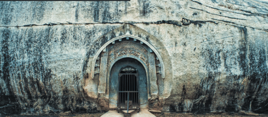
Rock cut cave in Barabar Hills, Bihar

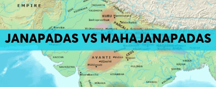
Q2: How did empires rise and shape Indian civilisation?
Ans:

  • Empires like Magadha and Maurya rose in areas with fertile land, rivers, iron, and trade routes.
  • They built strong armies, controlled trade, and created systems for tax collection and law enforcement.
  • Empires promoted art, architecture, and new ideas, influencing culture and religion (like Buddhism under Aśhoka).
  • They helped unite regions, reduce local wars, and spread knowledge across India and beyond.

Q3: What factors facilitated the transition from kingdoms to empires?
Ans:

  • Resources like iron tools, surplus food, and trade wealth helped small kingdoms grow stronger.
  • Strong leaders like Chandragupta Maurya and advisors like Kauṭilya made smart military and political decisions.
  • Trade routes and guilds brought economic power and connected regions.
  • The desire for power, fame, and control pushed rulers to conquer and unite more land.

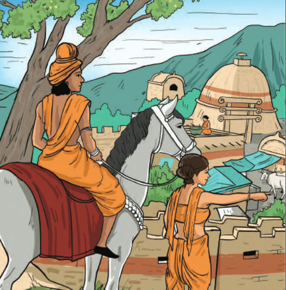
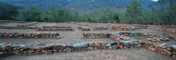
Artistic Representation of Pataliputra

Q4: What was life like from the 6th to the 2nd century BCE?
Ans:

  • Cities like Pataliputra became centers of trade, governance, and culture with planned streets and public buildings.
  • People included farmers, artisans, merchants, rulers, and performers, all playing roles in society.
  • The Mauryan Empire had a strong administration, fair laws, and supported religion, art, and public welfare.
  • Life was shaped by both military power and efforts for peace and well-being, especially under Emperor Aśhoka.

Back Questions (Page 114 & 115)

Q1: What are the features of an empire, and how is it different from a kingdom? Explain.
Ans: Features of an Empire:
An empire is a large political unit that consists of several smaller kingdoms or regions, each with its own ruler, but ultimately under the control of an emperor.

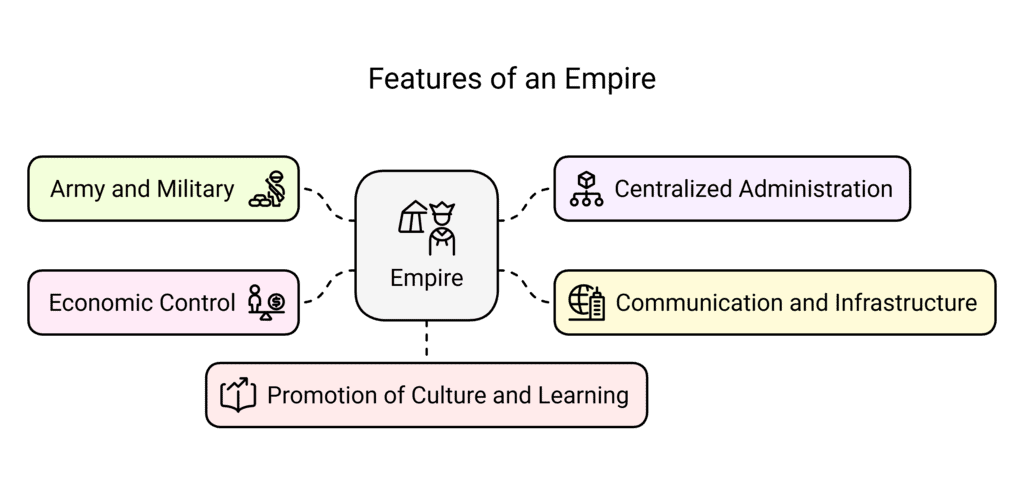
  • Army and Military: Empires maintain a large and well-organized army to keep the conquered territories under control, expand the empire, or defend against external threats.
  • Centralized Administration: The emperor exerts central authority over the empire’s tributary regions and kings. A well-organized administration collects taxes, maintains law and order, and ensures smooth governance.
  • Communication and Infrastructure: Empires have efficient communication networks, such as roads and river navigation, which support trade, administration, and welfare of the people.
  • Economic Control: The emperor controls and regulates resources, such as minerals, agricultural products, and manpower, ensuring a steady flow of wealth into the empire’s treasury.
  • Promotion of Culture and Learning: Empires encourage art, literature, religion, and education, contributing to the growth of cultural and intellectual life.

Difference Between a Kingdom and an Empire:

  • kingdom is a smaller region, typically ruled by a single king, where the king holds absolute power, and the territory is often limited to a specific geographical area.
  • An empire, on the other hand, is a collection of several kingdoms or territories, where the emperor has control over many regions, often through military conquest or alliances. While the smaller territories may still have their own rulers, they are considered tributaries to the emperor.
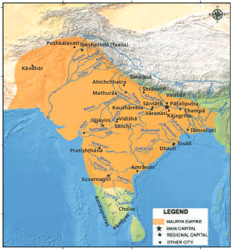
Mauryan Empire

Q2: What are some important factors for the transition from kingdoms to empires?
Answer: The transition from kingdoms to empires in ancient India was driven by several key factors:

  • Warfare and Conquest: As smaller kingdoms waged wars against each other, the more powerful kingdoms expanded through military campaigns. Conquered kingdoms were absorbed into the larger territory, eventually forming an empire.
  • Economic and Resource Control: The availability of resources, such as fertile land, forests, and minerals, played a crucial role in the rise of empires. Powerful kingdoms with economic wealth could support a larger army and infrastructure, allowing them to expand and control more regions.
  • Centralized Administration: As kingdoms grew larger, a need for more efficient governance and administrative control led to the establishment of centralized power, which is a key feature of empires.
  • Strategic Importance of Location: Kingdoms located in resource-rich regions or near important trade routes had the advantage of accumulating wealth, which helped them build strong armies and maintain stability, facilitating their transition into empires.

Q3: Alexander is considered an important king in the history of the world — why do you think that is so?
Ans: 

  • Military Conquests: Alexander, known as Alexander the Great, is famous for his military campaigns that expanded his empire across three continents. He defeated the Persian Empire and established control over parts of India, which changed the political landscape of the time.
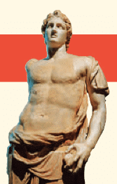
    Alexander the Great
  • Cultural Influence: Alexander’s conquests helped spread Greek culture and ideas throughout the regions he conquered. His empire facilitated the exchange of knowledge, art, and technology between the East and West, contributing to cultural diffusion.
  • Legacy: Even though Alexander’s empire was short-lived after his death, the impact of his rule is seen in the spread of Greek culture in the areas he conquered, particularly in the Hellenistic world. His campaigns opened the door for future interactions between Greek and Indian cultures.

Q4: In early Indian history, the Mauryas are considered important. State your reasons.
Ans: 

  • Foundation of the Mauryan Empire: The Mauryan Empire, founded by Chandragupta Maurya, was one of the largest and most powerful empires in Indian history. It unified much of the Indian subcontinent under a single ruler for the first time.
  • Administrative System: The Mauryas established a highly efficient and centralized administration that allowed for effective governance across vast regions. This system laid the foundation for future empires.
  • Economic Growth and Trade: The Mauryas promoted trade, both within the subcontinent and with other regions. They built roads, facilitated the use of coins, and created a stable economic environment that helped their empire flourish.
  • Promotion of Art and Architecture: The Mauryas contributed significantly to Indian art and architecture, with the construction of monumental structures such as the Sanchi Stūpa and the Ashokan Pillars.
  • Influence of Ashoka: Ashoka, one of the greatest Mauryan rulers, promoted the principles of peace, non-violence, and Buddhism, leaving a lasting impact on Indian culture and society.
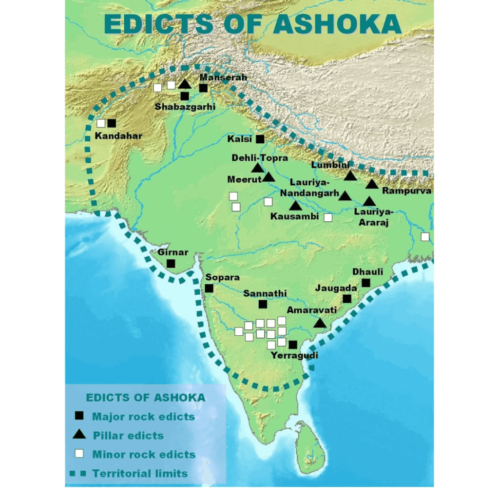
Edicts of Ashoka

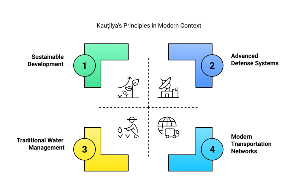
Q5: What were some of Kauṭilya’s key ideas? Which ones of these can you observe even today in the world around us?
Ans: Key Ideas of Kauṭilya (Chanakya):

  • Centralized Governance: Kauṭilya emphasized a strong central government with an emperor having control over the administration, military, and economy.
  • Law and Order: He believed that maintaining law and order was essential for the prosperity of the kingdom. His idea of a well-structured administration ensured the welfare of the people.
  • Diplomacy and Alliances: Kauṭilya advocated the use of diplomacy and strategic alliances to expand and maintain the empire.
  • Economic Management: He focused on the importance of a strong economy, including agriculture, trade, and taxation, to fund the empire’s needs.
  • Welfare of the People: Kauṭilya believed that a ruler’s happiness depended on the welfare of the people, and he promoted the idea of providing for the basic needs of the population.

Modern Relevance:

  • Centralized Governance: Modern governments still follow the idea of a central authority that controls the country’s affairs.
  • Economic Management: Governments today focus on maintaining economic stability, trade networks, and taxation systems, much like Kauṭilya’s ideas.
  • Welfare of the People: The modern welfare state aims to ensure the well-being of its citizens, reflecting Kauṭilya’s emphasis on the ruler’s duty to provide for the people.

Q6: What were the unusual things about Aśhoka and his empire? What of that has continued to influence India and why? Write your opinion in about 250 words.
Ans: Aśhoka, one of India’s most remarkable rulers, is known for his transformation from a war-hungry conqueror to a proponent of peace and non-violence after the Kalinga War. His reign marked a significant shift in governance:

  • War to Peace: Initially, Aśhoka expanded his empire through military conquest, but after witnessing the massive destruction caused by the Kalinga War, he embraced Buddhism and non-violence. His commitment to peace and welfare became central to his rule.
  • Dhamma Edicts: Aśhoka issued edicts inscribed on pillars and rocks across his empire, advocating for moral conduct (dharma), religious tolerance, and compassion for all living beings. These edicts, in Prakrit and Brahmi script, continue to influence Indian thought.
  • Promotion of Buddhism: Aśhoka played a key role in spreading Buddhism both within and outside India. His support for the Buddhist way of life has had a lasting impact on Indian culture and philosophy.
  • Legacy: Aśhoka’s legacy is seen in the emphasis on governance for the welfare of the people, religious tolerance, and the use of communication (through edicts) to connect with subjects. His ideals of peace, non-violence, and respect for all religions continue to shape India’s democratic and secular values today.

Q7: After reading the above edict of Aśhoka, do you think he was tolerant towards other religious beliefs and schools of thought? Share your opinion in the classroom.
Ans: 

  • Aśhoka’s edicts demonstrate his tolerance towards other religious beliefs and schools of thought. He mentions that his officers of Dhamma were responsible for interacting with people from various religious backgrounds, including Buddhists, Brahmins, Jains, and Ājīvikas. He encouraged the practice of peace and understanding among different sects and instructed his officers to promote tolerance and fairness.
  • Aśhoka’s acceptance of diverse philosophies, without forcing one belief over another, highlights his respect for different religious traditions. His emphasis on moral conduct (dhamma) rather than adherence to any single religion makes him an example of religious tolerance. This reflects his commitment to unity in diversity, which continues to be an important principle in India today.

Q8: The Brahmi script was a writing system that was widely used in ancient India. Try to learn more about this script, taking help from your teacher wherever required. Create a small project and include what you have learnt about Brahmi.
Ans: 

  • The Brahmi script was one of the earliest writing systems used in ancient India. It is considered the ancestor of many Indian scripts used today, including Devanagari, Bengali, Tamil, and more. Brahmi was used to write several ancient Indian languages, including Sanskrit and Prakrit.
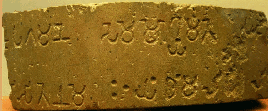
    Brahmi Script
  • The script is important because it was used in several inscriptions, including the famous Aśhoka Edicts, which helped historians understand the history and governance of the Maurya Empire. Brahmi is an example of alphabetic writing, where each symbol represents a sound, making it different from earlier pictographic scripts like those of the Harappan civilization.
  • For the project, you could create a chart or poster with examples of Brahmi symbols, their meanings, and how they evolved into modern scripts. This would help you understand how the script influenced the development of writing in India and its importance in preserving historical records.

Q9: Suppose you had to travel from Kauśhāmbī to Kāveripattanam in the 3rd century BCE. How would you undertake this journey, and how long would you expect it to take, with reasonable halts on the way?
Ans: In the 3rd century BCE, traveling between Kauśhāmbī and Kāveripattanam would have involved a long journey across India. Here’s how I would expect it to unfold:

  • Modes of Travel: The journey would most likely involve horseback ridingwalking, or using ox-drawn carts for the bulk of the trip. Ships may have been used for parts of the route, especially along the rivers or coastal areas.
  • Routes and Distance: The most common route would be Uttarapatha for the northern and central regions, and Dakṣhiṇapatha for the southern parts. Both routes connected important cities, and travelers would likely pass through several towns or trade hubs.
  • Time Estimate: With reasonable halts for rest, food, and trade, the journey could take several weeks. If we assume that a traveler could cover about 20 to 30 kilometers per day, it would likely take about two months to travel the full distance between these two places.

04. New Beginning: Cities and states Chapter Solution

The Big Questions (Page 68)

Q1: What is meant by ‘Second Urbanisation of India’?
Ans:

  • It refers to the rise of new cities around 1000 years after the Harappan Civilization ended.
  • These cities grew in the Ganga plains, Indus basin, and other regions around 1st millennium BCE.
  • It marked a shift from rural life to urban centres with trade, iron tools, and coin use.
  • This was when janapadas and mahājanapadas began to develop, leading to early states.

Ruins of a Major Structure at Rajagriha

Q2: Why were the janapadas and mahājanapadas an important development in India’s early history?
Ans:

  • They were India’s first organized territorial states with proper governance and capitals.
  • The mahājanapadas developed in fertile areas like the Ganga plains and became powerful kingdoms.
  • These regions promoted trade, agriculture, and the use of iron tools and coins.
  • They also helped spread Buddhism, Jainism, and new art and ideas across India.

Fertile Gangetic Plains

Q3: What kind of system of governance did they evolve?

Ans: 

  • Monarchies: Most mahajanapadas had kings (rajas) with hereditary power, supported by ministers and armies.
  • Republics (Ganas/Sanghas): Some states, like Vajji and Malla, followed early democratic traditions with decisions made by councils.
  • Councils like sabha and samiti advised rulers or took part in decision-making.
  • These systems show India had both monarchical and democratic forms of governance early on.

Back Questions (Page 81)

Q1: Consider the quotation at the start of the chapter and discuss in several groups. Compare your observations and conclusions on what Kauṭilya recommends for a kingdom. Is it very different today?
Ans: Kauṭilya’s Arthaśāstra provides a detailed guide for rulers on how to manage a kingdom effectively. His ideas are still relevant today, although the methods have evolved. Here are the main observations:

  • Fortification and Security: Kauṭilya recommends fortifying the capital and the towns at the frontiers to protect the kingdom from outside threats. This is essential for the safety of the kingdom.
    Today: Countries have advanced defense systems like military bases, radar systems, and security agencies.
  • Economic Sustainability: Kauṭilya stresses that the kingdom should have productive land with mines, forests, good pastures, and cultivable land to support both the population and outsiders in times of calamities.
    Today: This concept is still relevant in sustainable development, where countries ensure they have enough natural resources and economic systems (like trade, industries, etc.) to survive.
  • Water Management: He mentions the need for the kingdom to not depend on rain alone for water supply. A reliable water management system is essential.
    Today: Modern countries have developed advanced irrigation systems, reservoirs, and water treatment plants to manage water resources.
  • Infrastructure: Kauṭilya mentions the importance of good roads and waterways to ensure smooth trade and movement of goods.
    Today: Modern countries focus on well-connected transportation systems like highways, airports, and seaports to boost economic growth.

Overall, while Kauṭilya’s advice was focused on the basics of security, resources, and infrastructure, modern-day countries have developed advanced systems, including technology and global networks, to achieve these goals.

Q2: According to the text, how were rulers chosen in early Vedic society?

Ans: In early Vedic society, the process of choosing a ruler was not absolute and involved consultation with the assembly of elders. Here’s how it worked:

  • Rājā’s Role: The rājā (king) was expected to be a wise leader and consult with the sabhā or samiti (the council of elders). The king’s role was not absolute; his decisions were often influenced by the advice of the assembly.
  • Hereditary System: The position of the king was usually hereditary, meaning that the son of the previous king would often take the throne. However, it was not automatic; the council had an important role in approving the ruler’s actions.
  • Removal of an Incompetent Ruler: If the king was found to be incompetent or failing to meet his duties, the assembly could remove him from power. This shows that there was a system of checks and balances in place.

Thus, early Vedic rulers were chosen through a combination of hereditary succession and democratic consultation with the elders of the tribe.

Q3: Imagine you are a historian studying ancient India. What types of sources (archaeological, literary, etc.) would you use to learn more about the mahājanapadas? Explain how each source might contribute to your understanding.

Ans: As a historian studying ancient India, I would rely on several types of sources to gather information about the mahājanapadas:

  • Archaeological Sources: These include excavations, artifacts, inscriptions, and coins found from ancient sites.
    Contribution: These sources give us physical evidence about daily life, trade, art, and the architecture of ancient cities. Coins, for example, show us the economic systems, and inscriptions provide information on the administration and laws of the mahājanapadas.
  • Literary Sources: Texts from the Vedic, Buddhist, and Jain traditions contain references to the political systems, cultural practices, and religious beliefs of the time.
    Contribution: Epics like the Mahābhārata and texts like the Anguttara Nikāya provide insights into the geography, people, and the political systems of the mahājanapadas.
  • Numismatic Sources: The study of coins, particularly punch-marked coins, provides clues about trade, economy, and the polity.
    Contribution: Coins tell us about the economic relations between different regions and the rulers of the mahājanapadas.

By using these sources, historians can reconstruct a picture of politics, culture, and society in the mahājanapadas.

Q4: Why was the development of iron metallurgy so important for the growth of urbanism in the 1st millennium BCE?
Ans: The development of iron metallurgy had a profound impact on the growth of urbanism in the 1st millennium BCE. Here’s why:

Metal Workshop depicted at Sanchi Stupa

  • Agricultural Growth: The use of iron tools, such as plows, made farming more efficient. This led to increased agricultural production, which supported larger populations in urban areas.
  • Stronger Weapons: Iron weapons, like swords, spears, and arrows, were stronger and sharper than bronze. This allowed kingdoms to defend their territories better and expand their empires through warfare.
  • Building and Urbanization: Iron tools helped in the construction of cities and fortifications. Stronger tools meant that better infrastructure could be built, which is crucial for the growth of urban centers.
  • Trade and Economy: The rise in agricultural productivity and military efficiency promoted trade. Iron itself became an important commodity for trade, contributing to the growth of urban economies.

Overall, iron metallurgy played a key role in shaping the economic and political landscape, making it a driving force behind the rise of urban centers.

03. Climates Of India Chapter Solution

The Big Questions (Page 45)Q1: What makes India’s climate so diverse?
Ans:

  • India’s varied geography—mountains, deserts, plateaus, and coasts—creates different climates.
  • Latitude (distance from the Equator) and altitude (height above sea level) affect temperature and rainfall.
  • Places near the sea have mild weather, while inland areas have extreme temperatures.
  • Winds and topography (land shape) also influence rainfall and temperature.

Climate of India

Q2: What are the monsoons? How are they formed?
Ans:

  • Monsoons are seasonal winds that bring heavy rainfall, important for farming in India.
  • In summer, warm land pulls in moist air from the ocean, causing rainfall (Southwest Monsoon).
  • In winter, cool land pushes dry winds to the sea, causing dry weather (Northeast Monsoon).
  • Monsoons form due to differences in temperature and pressure between land and sea.

Q3: What is the effect of climate on economy, culture, and society?
Ans:

  • Good or bad monsoon affects farming, food supply, and prices in markets.
  • Many festivals and traditions are linked to seasons and harvests, like Baisakhi and Onam.
  • People wear different clothes, grow different crops, and build homes based on the climate.
  • Industries also need stable climate and water supply to work properly.

Natural Disasters

Q4: How can understanding the climate help us to prepare for natural disasters?
Ans:

  • Knowing the climate helps predict disasters like cyclones, floods, and droughts.
  • Weather departments (like IMD) give warnings in advance to protect people and property.
  • Government teams (like NDRF) can plan rescue efforts and move people to safety.
  • This helps reduce loss of life, damage to homes, and harm to crops or animals.

Q5: What is climate change? What are its consequences?
Ans:

  • Climate change means long-term changes in weather patterns caused by human actions.
  • Burning fossil fuels and cutting trees release greenhouse gases, which trap heat and cause global warming.
  • Effects include extreme weather, shorter winters, crop failure, and harm to small industries.
  • Solutions include using renewable energy, planting trees, and reducing pollution.

Back Questions (65 & 66)Q1: Match the climatic factors with their effects:

Ans: 

1. Latitude (b) Creates different climates in the north and south: Latitude determines how much sunlight an area receives. Areas near the Equator are warmer, while those further north or south are cooler, like South India being warmer than North India.

2. Altitude (c) Keeps higher places cooler: At higher altitudes, the air is thinner and cooler. Hill stations like Shimla and Darjeeling are cooler than the plains due to their high altitude.

3. Proximity to the ocean (d) Moderates the temperature: Coastal areas are less affected by extreme temperatures because the sea keeps the temperature more even, making places like Mumbai cooler in summer and warmer in winter compared to inland cities like Nagpur.

4. Monsoon winds (a) Brings wet air to India during summer: The monsoon winds carry moist air from the ocean, bringing heavy rainfall to India during the summer months, which is essential for agriculture, especially in regions like Kerala and Maharashtra.

Q2: Answer the following questions:
a) What is the difference between weather and climate?
Ans:

  • Weather refers to the atmospheric conditions at a specific time and place. It changes frequently and can be sunny, rainy, windy, or cloudy.
  • Climate, on the other hand, is the long-term pattern of weather in a particular region over many years, usually decades. It includes the average weather conditions and seasonal changes in temperature, precipitation, and other atmospheric elements.

Difference between Weather and Climate

b) Why do places near the ocean have milder temperatures than places far away from it?
Ans: Places near the ocean have milder temperatures because the sea has a moderating effect on the climate. Water heats up and cools down more slowly than land. This means that coastal areas experience cooler summers and warmer winters compared to inland areas. For example, Mumbai, being near the sea, has cooler summers than Nagpur, which is further inland.

c) What role do monsoon winds play in affecting India’s climate?
Ans: Monsoon winds bring heavy rainfall to India during the monsoon season (from June to September). These winds blow from the southwest towards the land, carrying moisture from the Indian Ocean. As the moisture-laden winds rise over the Western Ghats, they cool and condense to form rain. This rainfall is vital for agriculture, especially for crops like rice, and plays a major role in the climate of India.

d) Why is Chennai warm or hot throughout the year, while Leh is cold?
Ans:

  • Chennai is located near the coast and experiences a tropical climate. The sea moderates its temperature, keeping it hot and humid throughout the year.
  • Leh, on the other hand, is located in the Himalayas at a high altitude. This causes it to have an alpine climate, where the temperature is much cooler, even during the summer, and cold in winter.

Q3: Look at a map of India given at the end of this book. Identify the climate for these cities—Leh, Chennai, Delhi, Panaji, and Jaipur.

Q4: Draw the monsoon cycle in summers and winters on a map of India.
Ans:

  • Summer Monsoon (June to September): Winds blow from the southwest (from the Indian Ocean) bringing moisture and rain to India. The rains start in the southern tip and move northward, covering the entire subcontinent by mid-July.
  • Winter Monsoon (October to February): Winds reverse and blow from land to the sea, bringing dry weather and cool temperatures. These winds bring some moisture to parts of East and South India.

Q5: Make a colourful poster showing festivals in India linked to farming and weather (e.g., Baisakhi, Onam).
Ans: Instructions for students:
Create a poster with images or drawings of festivals such as:

  • Baisakhi (celebrating the harvest of wheat in Punjab),
  • Onam (celebrating the rice harvest in Kerala),
  • Pongal (harvest festival in Tamil Nadu).

Include images of farmerscrops, and celebrations such as dances and traditional food associated with these festivals.
Here is the sample Poster: 
Seasons influencing festivals

Q6: Imagine you are a farmer in India. Write a short diary entry about how you would prepare for the rainy season.
Ans: Diary Entry: “Today, I am preparing for the rainy season. I’ve cleaned my fields and checked the irrigation system to ensure it works well when the rains start. I’ve also arranged my seeds and tools in good condition. The monsoon rains are important for my crops, especially for rice. I will plant the seeds as soon as the rains arrive. I hope the rains come on time so my crops can grow well and I can have a good harvest.”

Q7: Identify a natural disaster (e.g., cyclone, flood, landslide, or forest fire) and write a short essay that includes the causes and impacts. Suggest actions that individuals, communities, and the government can take to reduce the impact.
Ans: Essay on Cyclones:
Causes:Cyclones are formed when low-pressure systems develop over warm ocean waters. The warm air rises and draws in more air, which picks up moisture. When the system strengthens, it can lead to high winds, heavy rain, and the formation of a cyclone.
Impacts:

  • Loss of life and property.
  • Destruction of crops and farmlands.
  • Damage to infrastructure, such as roads and buildings.
  • Soil erosion and destruction of natural habitats.

Actions to Reduce the Impact:

  • Individuals: Stay informed about weather warnings, have an emergency kit ready, and evacuate if necessary.
  • Communities: Build better, stronger houses that can withstand cyclonic winds and set up evacuation plans.
  • Government: Improve early warning systems, build disaster-resilient infrastructure, and train disaster response teams. Conduct regular drills for preparedness.

02. Understanding the weather Chapter Solution

The Big Questions (Page 27)Q1: How can we measure and monitor the weather around us?
Ans: We Measure the weather with following ways: 

  • Weather is measured using instruments like thermometers (temperature), rain gauges (rain), barometers (air pressure), anemometers (wind speed), and hygrometers (humidity).
  • These instruments are used together at weather stations to get accurate data.
  • Automated Weather Stations (AWS) use sensors to collect weather data without human help.
  • This data helps scientists understand weather patterns and give daily weather updates.

Weather

Q2: How do weather predictions help us prepare for events like heavy rain, storms, drought and heat waves?
Ans:

  • Accurate weather predictions help warn people about dangerous weather like cyclones, storms, or heatwaves.
  • Fishermen, farmers, and pilots use these predictions to stay safe and plan better.
  • Governments can prepare for emergencies, like evacuating people during cyclones or arranging water in drought areas.
  • The India Meteorological Department (IMD) issues these warnings using scientific data and weather maps.

Back Questions (Page 42 & 43)Q1: Match the instrument with the weather element it measures.

Ans: We can measure and monitor the weather using various instruments that help us track different elements of the weather. These instruments help us understand and predict the weather conditions we experience. 
Here’s how each element of the weather is measured:

  1. Hygrometer (Measures Humidity):
    hygrometer is used to measure the humidity, or the amount of water vapour in the air. It helps us understand how dry or wet the air is, which can affect how we feel in hot or cold weather.
  2. Anemometer (Measures Wind Speed and Direction):
    The anemometer measures the wind speed and direction. It has rotating cups that spin faster when the wind blows harder, and it helps to know how fast the wind is moving.
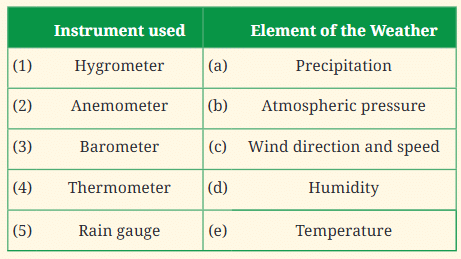
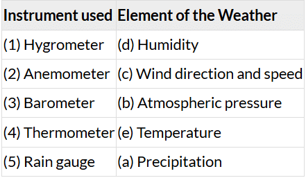
  3. Barometer (Measures Atmospheric Pressure):
    barometer measures the atmospheric pressure, or the weight of the air around us. Changes in pressure can help predict weather changes. Low pressure often leads to storms, while high pressure generally brings clear, calm weather.
    Barometer
  4. Thermometer (Measures Temperature):
    thermometer measures temperature, or how hot or cold the air is. Temperature affects our clothing choices and helps us prepare for hot or cold weather conditions.
    Thermometer
  5. Rain Gauge (Measures Precipitation):
    rain gauge measures precipitation, or the amount of rain, snow, or hail that falls from the sky. It collects water in a container, and the level of water tells us how much rain has fallen.

These instruments help meteorologists (weather scientists) track and predict weather patterns, allowing us to prepare for events like rain, heat, or wind.

Q2: Jyotsna is deciding what clothes to pack for her school trip to Mumbai in June. She looks at the weather forecast, which predicts 29°C and 84% humidity. What would be your advice to her?
Ans: Since Mumbai in June is likely to be warm with high humidity, Jyotsna should pack clothes that are light and comfortable. Cotton clothes would be a good choice as they are breathable and help in staying cool. She should also pack a hat or cap to protect herself from the sun, and carry an umbrella or a raincoat, as June is the monsoon season in Mumbai, which means there could be occasional rain showers. Additionally, carrying a water bottle is important to stay hydrated in the humid weather.

Q3: Imagine that a small group of students is setting up a rain gauge. Here are some options for the site. 
1. The school vegetable garden. 
2. The terrace of the school building. 
3. Open ground with an elevated platform. 
4. Compound wall of school. 
5. Verandah of the school laboratory. 
Discuss in your group and finalise the site. Write down the reasons for your decision.
Ans: The best location to set up the rain gauge would be Open ground with an elevated platform (Option 3). The reasons for this choice are:

Rain Gauge

  • Open ground: This ensures that the rain gauge is not obstructed by trees, buildings, or other structures, which might block the rain and give incorrect readings.
  • Elevated platform: The elevated platform ensures that the rain gauge is above the ground, preventing any soil or debris from interfering with the measurement of rainfall. This setup ensures a more accurate measurement.

The terrace or the compound wall might have obstructions that could alter the readings, and the school vegetable garden or the verandah could be subject to interference from surrounding objects.

Q4: Below is a chart taken from IMD, Jammu and Kashmir. Looking at the data available, write a short script to report the weather conditions in different parts of Jammu and Kashmir on the date shown. (Hint: Cover the temperature range, maximum and minimum temperatures, humidity, precipitation, etc.)

Ans: DATE: 01-02-2024
Good evening, everyone! Here’s your weather update for Jammu and Kashmir on 01-02-2024. Let’s take a look at the weather across different regions of the state:

  1. SRINAGAR:
    • Maximum Temperature: 6.5°C (lower than normal by 2.4°C)
    • Minimum Temperature: 0.2°C (lower than normal by 0.7°C)
    • Humidity: 89% at 0830 hrs, 89% at 1730 hrs. It’s a relatively humid day.
    • Precipitation: Light rain with a trace amount of snowfall (TR).
    • Summary: The weather is cool with slight rain, and the temperatures are below the usual for this time of year. It’s a mild and chilly day.
  2. QAZIGUND:
    • Maximum Temperature: 3.2°C (lower than normal by 5.3°C)
    • Minimum Temperature: -0.4°C (lower than normal by 2.1°C)
    • Humidity: 97% at 0830 hrs, 90% at 1730 hrs. The humidity is high, indicating a damp atmosphere.
    • Precipitation: Moderate rain (11.8 mm) with snow (10.0 cm).
    • Summary: Qazigund is experiencing cold weather, well below normal temperatures, with moderate rain and snowfall. The day is quite chilly with high humidity.
  3. PAHALGAM:
    • Maximum Temperature: 1.1°C (lower than normal by 4.5°C)
    • Minimum Temperature: -4.1°C (lower than normal by 6.1°C)
    • Humidity: 96% at 0830 hrs, 96% at 1730 hrs. Very high humidity levels.
    • Precipitation: Moderate rain (6.0 mm) with snowfall (10.0 cm).
    • Summary: Pahalgam is very cold today, with temperatures well below normal, and significant snowfall along with moderate rainfall. It’s a wet and freezing day.
  4. KUPWARA:
    • Maximum Temperature: 5.1°C (lower than normal by 3.4°C)
    • Minimum Temperature: -0.7°C (lower than normal by 2.3°C)
    • Humidity: 97% at 0830 hrs, 94% at 1730 hrs. Humidity remains high throughout the day.
    • Precipitation: Light rainfall (21.9 mm) with snowfall (8.0 cm)
    • Summary: Kupwara is experiencing cool and damp conditions with rain but no snowfall. The temperatures are lower than usual, and high humidity persists.
  5. KUKERNAG:
    • Maximum Temperature: 2.6°C (lower than normal by 4.0°C)
    • Minimum Temperature: -1.4°C (lower than normal by 2.4°C)
    • Humidity: 96% at 0830 hrs, 97% at 1730 hrs. High humidity is observed.
    • Precipitation: Moderate rainfall (12.0 mm) with snowfall (8.0 cm).
    • Summary: Kukernag is colder than usual with moderate rainfall and some snowfall. The day remains damp with high humidity.
  6. GULMARG:
    • Maximum Temperature: -2.6°C (lower than normal by 4.0°C)
    • Minimum Temperature: -7.6°C (lower than normal by 7.6°C)
    • Humidity: 76% at 0830 hrs, 100% at 1730 hrs. The humidity is very high, likely due to the snow.
    • Precipitation: Moderate rainfall (8.2mm) but snowfall (6.35 cm).
    • Summary: Gulmarg is experiencing very cold conditions, with snowfall throughout the day. The temperatures are well below normal, and high humidity adds to the chill.
  7. MUZAFARABAD:
    • Maximum Temperature: 8.5°C (no normal data available)
    • Minimum Temperature: 5.6°C (no normal data available)
    • Humidity: 93% at 0830 hrs, no data available at 1730 hrs.
    • Precipitation: No precipitation data available.
    • Summary: Muzafarabad is experiencing mild weather with moderate temperatures and high humidity, though no rainfall or snowfall has been recorded.

That’s all for your weather update in Jammu and Kashmir today. Be sure to stay prepared for cold weather, especially in the higher altitudes, with snow and rain expected in many parts. Have a great evening, and stay safe!

01. Geographical Diversity of India Chapter Solution

The Big Question (Page 1)Q1: What are some key geographical features of India?
Ans: The key geographical features of India are:

  • India has many types of landforms like mountains, plains, deserts, plateaus, coasts, and islands.
  • The Himalayas in the north are tall mountains that protect India and give rise to important rivers.
  • The Gangetic Plains are flat and fertile, ideal for growing crops and supporting large populations.
  • Other major features include the Thar Desert, the Deccan Plateau, and long coastlines with many islands.

Jog Falls in Karnataka

Q2: How does India’s geographical diversity affect our lives?
Ans: India’s geographical diversity affect our lives by following ways:

  • People wear different clothes, eat different food, and celebrate different festivals based on the region they live in.
  • Geography affects farming, trade, and transport—plains are good for crops, and coasts help in fishing and shipping.
  • People in deserts, mountains, and forests adapt their lifestyles to survive in their environment.
  • The variety of landscapes supports rich biodiversity, tourism, and natural resources like water, minerals, and forests.

Back Questions (Page 24 & 25)Q1: What, in your opinion, are two important geographical features of India? Why do you think they are important?
Ans:Two important geographical features of India are:

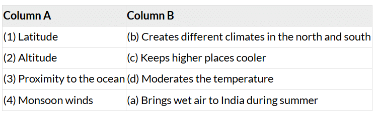
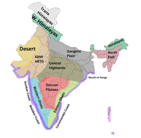
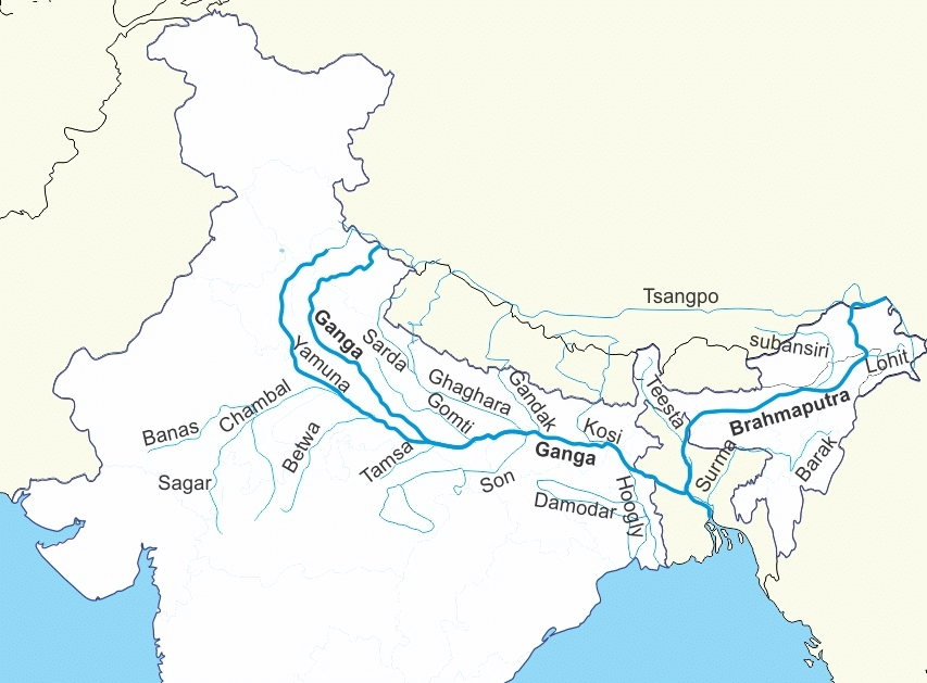
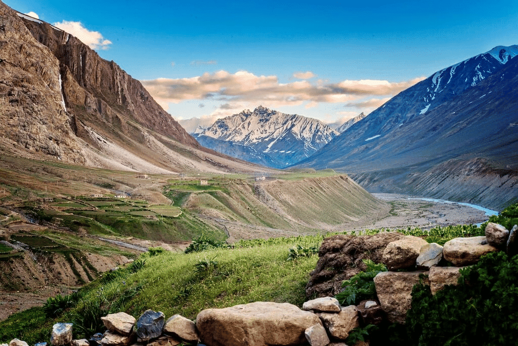
  • The Himalayas: The Himalayan mountain range is one of the most significant geographical features in India. It forms a natural boundary between India and the countries to its north, such as China and Nepal. The Himalayas are important because they influence the climate of India, as they block the cold winds from the north, creating a warmer climate in the plains. They also feed major rivers, like the Ganga and the Brahmaputra, which are crucial for agriculture and daily life. Additionally, the Himalayas are home to various species of plants and animals, making them an ecological hotspot.
    Satellite Image of Himalayan Range
  • The Gangetic Plains: The Gangetic Plains, located in the northern part of India, are known for their fertile soil, which is enriched by the Ganga and its tributaries. This feature is crucial because it supports the majority of India’s population due to its fertile land, which is ideal for agriculture. The region is the breadbasket of India, growing crops such as rice, wheat, and sugarcane. The rivers that flow through this region are also used for irrigation and transport.

Q2: What do you think India might have looked like if the Himalayas did not exist? Write a short note or sketch a drawing to express your imagination.
Ans:

  • If the Himalayas did not exist, India would have a very different landscape. The northern regions, which are currently protected by the Himalayas from the cold winds from Central Asia, would experience much colder temperatures. 
  • The absence of the Himalayas would likely lead to a loss of the snow-fed rivers like the Ganga, which are essential for agriculture. Additionally, the absence of the mountains would mean a lack of the scenic beauty and natural barriers that have helped preserve India’s unique biodiversity. 
  • The north of India could be more prone to extreme cold conditions, and the cultural significance of the Himalayas as a sacred and spiritual place would be lost.
  • In terms of landforms, India might have been more like a flat or rolling plateau without the high mountain ranges. This might also have impacted the flow of the major rivers, altering their course and effect on agriculture.

Q3: India has been called a ‘mini-continent’. Based on what you’ve read, why do you think this is so?
Ans: India is called a ‘mini-continent’ because of its vast geographical diversity. It has all types of landforms, including mountains, plateaus, deserts, and coastlines, which are usually found across different continents. For example:

Geographic Regions of India

  • The Himalayas in the north represent high mountain ranges, similar to the ones found in other parts of the world, like the Alps in Europe.
  • The Thar Desert in the west is similar to deserts found in Africa and the Middle East.
  • The Gangetic Plains provide fertile land for agriculture, much like the plains of other river systems around the world.
  • The peninsular plateau in the south resembles regions of central Africa or South America.

This diversity in geographical features, climate, flora, and fauna, along with the vast range of cultures and languages, makes India resemble a continent on its own.

Q4: Follow one of India’s big rivers from where it starts to where it meets the ocean. What are the different ways in which people might utilize this river along its journey? Discuss in groups in your class.
Ans: Let’s take the Ganga River as an example:

Gaumukh

  • Source: The Ganga starts from the Gaumukh glacier in the Himalayas, where the snow melts to form the river. It is the source of water for millions of people.
  • In the Hills: As the Ganga flows through the Himalayas, it is used for drinking, irrigation, and as a source of hydroelectric power.
  • In the Plains: As the Ganga enters the plains, it becomes the lifeline of agriculture for the region, providing water for irrigation. It is also used for transport by boat, especially in areas with no road infrastructure. Additionally, the river has been historically important for trade.
  • Cultural Significance: The Ganga is considered sacred, and it attracts millions of pilgrims who bathe in its waters to wash away sins.
  • Mouth of the River (Delta): When the Ganga reaches the Bay of Bengal, it forms a delta, and the river is used for fishing, transport, and supporting the local economy through agriculture.

Ganga River

Q5: Why is the southern part of India referred to as a peninsular plateau?
Ans:

  • The southern part of India is referred to as a peninsular plateau because it is a large, triangular landmass that is elevated above the surrounding areas and is surrounded by water on three sides. 

Peninsular Plateau

  • This plateau is bordered by the Western Ghats and Eastern Ghats and is also known as the Deccan Plateau. Being a plateau, the land is generally flat and raised, making it an important area for mining, agriculture, and various industries. 
  • The plateau also has a significant number of rivers that flow across it, providing water for irrigation and power generation.

Q6: Which UNESCO Heritage Site mentioned in this chapter did you find more interesting? Write a short paragraph to describe what about it is interesting.
Ans:

  • One of the UNESCO World Heritage Sites mentioned in this chapter that I find interesting is the Great Himalayan National Park in Himachal Pradesh. 
  • This park is rich in biodiversity and is home to a wide variety of plants and animals, many of which are rare or endangered. The park is also significant for its role in preserving the unique ecosystem of the Himalayas. 
  • It provides a natural habitat for species like the snow leopard, Himalayan monal, and several types of rhododendrons. 
  • The park’s conservation efforts are a great example of how local communities work alongside the government to protect natural habitats, making it a fascinating place for both nature lovers and conservationists.

Q7: Look at the two maps of India, physical as well as political, given at the end of this book. Identify the place you are at now. Which physical feature of India would you use to describe its location?
Ans: Based on the physical map of India, the place I am located at is [insert location here]. The physical feature I would use to describe its location would depend on the landform near me. For example:

  • If I am in the north, I would say that I am near the Himalayas, which forms a natural barrier to the north.
  • If I am in the west, I could say that I am near the Thar Desert.
  • If I am in the south, I might say I am near the Peninsular Plateau and surrounded by water on three sides, forming a peninsula.

Q8: Food preservation techniques differ from place to place across India. They are adapted to local conditions. Do a class project. Gather different methods of preserving food. Hint: Drying vegetables when they are in season for use during the off-season.
Ans: Food preservation techniques in India vary based on climate and available resources. Some examples include:

  • Drying: In many parts of India, people dry vegetables and fruits like mangoes, tomatoes, and carrots to preserve them for off-season use. This method is commonly used in rural areas, especially in dry and hot climates.
  • Pickling: In regions like Rajasthan and Gujarat, pickling is a common method to preserve fruits and vegetables such as mangoes, lemons, and carrots. These are preserved with spices and oils.
  • Salting and Smoking: In coastal regions, fish and meat are preserved by salting and smoking to keep them for longer periods.
  • Canning and Jarring: In urban areas, modern methods like canning and jarring are also used to preserve fruits and vegetables.

Q9: Despite having such different regions (mountains, deserts, plains, coasts), India remains one country. How do you think our geography has helped unite people?
Ans: India’s geography, despite its vast diversity, has played a significant role in uniting people in several ways:

  • Rivers as Lifelines: Major rivers like the Ganga, Brahmaputra, and Indus have provided water and resources for agriculture, enabling people across different regions to depend on these rivers for their livelihoods. This common resource has helped create a sense of unity among people.
  • Cultural Exchange: India’s vast geographical features like the Himalayas, deserts, and coasts have not isolated people but have facilitated cultural exchange. Trade routes across the mountains, plains, and coasts have allowed people to interact, share ideas, and build relationships.
  • Transportation Networks: The flat Gangetic Plains and the development of roads and railways have made it easier for people to travel, trade, and connect with others from different parts of the country. This connectivity has helped unify diverse communities.
  • Shared Heritage: India’s history, influenced by its geography, has fostered a shared sense of identity and culture that transcends regional differences, allowing people from different parts of India to feel connected to a common heritage.

12. Earth,moon, and the Sun Chapter Solution

Q1: In Fig. 12.17, how many hours of sunlight do the North Pole and the South Pole receive during one rotation of the Earth?
Ans: During one rotation of the Earth, the North and South Poles experience 24 hours of either sunlight or darkness, depending on the season. This is because the Earth’s axial tilt causes these poles to either face the sun constantly (24 hours of sunlight) or be completely shielded from the sun (24 hours of darkness) for periods of several months. 

According to the figure, the South Pole is receiving 24 hours of sunlight, while the North Pole is in complete darkness.

Q2: Fill in the blanks

(i) Stars rise in the _________ and set in the ___________.

 Ans: Stars rise in the East and set in the West.

(ii) Day and night are caused by the Earth’s __________________.

Ans: Day and night are caused by the Earth’s rotation.

(iii) When the Moon fully covers the Sun from our view, it is called a _____________ solar eclipse.

Ans:  When the Moon fully covers the Sun from our view, it is called a total solar eclipse.

Q3: State whether True or False
(i) Lunar eclipse occurs when the Sun comes between the Earth and the Moon. 

Ans: False
A lunar eclipse happens when the Earth is between the Sun and the Moon. This causes the Earth’s shadow to fall on the Moon, blocking the Sun’s light.

(ii) Sunrise happens earlier in Gujarat than in Jharkhand. 

Ans: True
Gujarat is located to the west of Jharkhand, so the Sun rises earlier in Gujarat because of its position relative to the Earth’s rotation.

(iii) In Chennai, the longest day occurs on the summer solstice. 

Ans: True
The longest day of the year happens on the summer solstice, which occurs around June 21st. Chennai, being in the Northern Hemisphere, experiences its longest day during this time.

(iv) We should watch the solar eclipse directly with our naked eye.

Ans: False
Looking at a solar eclipse directly without protective glasses can damage your eyes, as the Sun’s rays are harmful.

(v) Seasons occur due to the tilt of Earth’s axis of rotation and its spherical shape.

Ans: True
The tilt of the Earth’s axis and its spherical shape cause the Sun’s rays to hit different parts of the Earth at different angles throughout the year, creating the four seasons.

(vi) The Earth’s revolution around the Sun causes day and night.

Ans: False
Day and night are caused by the Earth’s rotation on its axis, not its revolution around the Sun. The Earth rotates, creating the cycle of day and night.

Q4: Padmashree saw the Orion constellation nearly overhead at 8 pm yesterday. When will she see Orion overhead today?
Ans: She will see Orion overhead approximately 4 minutes earlier each day due to the Earth’s rotation and revolution.

Q5: Nandhini saw a group of stars rising at midnight on 21 June. When will she see the same group of stars rising at midnight next year?
Ans: Nandhini will see the same group of stars rising at midnight on 21 June next year as well, since the Earth completes one full revolution around the Sun in about 365 days, so the position of the stars is similar each year.

Q6: Abhay noticed that when it was daytime in India, his uncle who was in the USA was generally sleeping as it was night-time there. What is the reason behind this difference?
Ans: This difference is due to the Earth’s rotation. As the Earth rotates, different parts of the world experience day and night at different times. India and the USA are in different time zones.

Q7: Four friends used the following ways to see the solar eclipse. Who among them was being careless?
(i) Ravikiran used a solar eclipse goggle.
Ans: Safe
(ii) Jyothi used a mirror to project the Sun’s image. 
Ans: Safe
(iii) Adithya saw the Sun directly with his eyes. 
Ans: Careless
(iv) Aruna attended a programme arranged by a planetarium. Safe

Q8: Fill in the circles in Fig. 12.18 appropriately with one of the following: Sun, Moon, Earth.
Ans:

  • Solar Eclipse: Sun – Moon – Earth
  • Lunar Eclipse: Sun – Earth – Moon

Q9: The Moon is much smaller than the Sun, yet it can block the Sun completely from our view during a total solar eclipse. Why is it possible?
Ans: The Moon can block the Sun completely during a total solar eclipse because it is much closer to the Earth than the Sun. The apparent sizes of the Moon and the Sun are similar when viewed from Earth.

Q10: The Indian cricket team matches in Australia are often held in December. Should they pack winter or summer clothes for their trip?
Ans: The Indian cricket team should pack summer clothes for their trip to Australia in December because, in the Southern Hemisphere, December is summer. While India experiences winter during this time, Australia has warm weather, so they will need light and comfortable clothing suitable for summer.

Q11: Why do you think lunar eclipses can be seen from a large part of the Earth when they happen, but total solar eclipse can be seen by only a small part of the Earth?
Ans: Lunar eclipses are visible from a larger part of the Earth because the Earth’s shadow is large, and it covers a wide area. A solar eclipse, however, is visible only from a small part of the Earth because the Moon’s shadow is much smaller and concentrated in specific regions.

Q12: If the Earth’s axis were not tilted with respect to the axis of revolution, explain what would be the effect on seasons?
Ans: If the Earth’s axis were not tilted, there would be no seasonal changes. The amount of sunlight received at different latitudes would remain the same throughout the year, leading to a uniform climate year-round.

11. Light: Shadows and Reflections Chapter Solution

Q1: Which of the following are luminous objects?

Ans:  Luminous objects- Sun, Pole Star, and Venus are luminous objects because they emit their own light. 

Non-Luminous objects- The Moon and Mars are non-luminous objects as they reflect light and don’t have light of their own.

Q2: Match the items in Column A with those in Column B.

Ans:

  • Pinhole camera → Forms an inverted image
    A pinhole camera creates an inverted image due to the way light passes through the small hole.
  • Opaque object → Blocks light completely
    An opaque object does not let light pass through it, so it blocks light completely.
  • Transparent object → Light passes almost completely through it
    A transparent object allows most of the light to pass through, making things visible through it.
  • Shadow → The dark region formed behind the object
    A shadow is formed when an object blocks light, creating a dark area behind it.

Q3: Sahil, Rekha, Patrick, and Qasima are trying to observe the candle flame through the pipe as shown in Fig. 11.16. Who can see the flame?

Ans: Rekha can see the flame through the pipe because the light from the flame travels in a straight line. For the light to pass through the pipe, it must follow a direct path without any obstructions or bends.

For Sahil, Patrick, and Qasima pipe is bent. Hence, the light would not be able to travel and reach their eyes. 

Q3: Look at the images shown in Fig. 11.17 and select the correct image showing the shadow formation of the boy

Ans: The shadow formed will be based on the position of the light source relative to the object (the boy). If the light is positioned in front of the boy, the shadow will fall behind him.

Q4: The shadow of a ball is formed on a wall by placing the ball in front of a fixed torch as shown in Fig. 11.18. In scenario (i) the ball is closer to the torch, while in scenario (ii) the ball is closer to the wall. Choose the most accurate representation of the shadows formed in both scenarios from the options provided (a and b).

Ans: Scenario (i): When the ball is closer to the torch, the shadow will be larger because the light is spreading out more and the ball blocks more light.

Scenario (ii): When the ball is closer to the wall, the shadow will be smaller because the ball is farther from the torch, so it blocks less light.

In simple terms:

  • Closer to the torch → bigger shadow
  • Closer to the wall → smaller shadow

Q6: Based on Fig. 11.18, match the position of the torch in Column A with the characteristics of the ball’s shadow in Column B.

Ans:

  • If the torch is close to the ball → The shadow would be smaller
    The shadow would be smaller because the light is more spread out when the torch is close.
  • If the torch is far away → The shadow would be larger
    The shadow would be larger because the light will cover a wider area as the torch is far away.
  • If the ball is removed from the setup → Two shadows would appear on the screen
    Two shadows would appear on the screen because without the ball blocking the light, both torches will create shadows.
  • If two torches are present in the setup on the left side of the ball → A bright spot would appear on the screen
    A bright spot would appear on the screen where the two light sources meet and overlap.

Q7: Suppose you view the tree shown in Fig. 11.19 through a pinhole camera. Sketch the outline of the image of the tree formed in the pinhole camera.

Ans: In a pinhole camera, the image is upside down and inverted because light travels in straight lines. The top of the object (the tree) hits the bottom of the screen, and the left side hits the right side, causing the image to appear reversed.

Q8: Write your name on a piece of paper and hold it in front of a plane mirror such that the paper is parallel to the mirror. Sketch the image. What difference do you notice? Explain the reason for the difference.

Ans: The image of the name will be reversed, as mirrors cause lateral inversion. The left side of the name will appear as the right side in the mirror and vice versa.

Q9: Measure the length of your shadow at 9 AM, 12 PM, and 4 PM with the help of your friend. Write down your observations:
(i) At which of the given times is your shadow the shortest?

Ans: The shadow is the shortest at 12 PM when the Sun is directly overhead.

During the day, as the Earth rotates, the angle at which the Sun’s rays hit the ground changes. In the morning (9 AM) and late afternoon (4 PM), the Sun is lower in the sky, so its rays strike the ground at a steeper angle, causing a longer shadow.

(ii) Why do you think this happens?

Ans: This is because: 

  • At this time, the Sun is at its highest point in the sky, meaning it is directly above you.
  •  The Sun’s rays are shining down almost vertically, so the shadow is at its shortest. 
  • The angle between the Sun’s rays and the ground is the smallest, resulting in a small, short shadow.

Q10: On the basis of following statements, choose the correct option.

Statement A: Image formed by a plane mirror is laterally inverted.

Statement B: Images of alphabets T and O appear identical to themselves in a plane mirror.

(i) Both statements are true
(ii) Both statements are false
(iii) Statement A is true, but statement B is false
(iv) Statement A is false, but statement B is true

Ans: (i) Both statements are true. 

Statement A is true as plane mirrors create laterally inverted images.

Statement B is true because some letters (like T and O) look the same in a mirror.

Q11: Suppose you are given a tube of the shape shown in Fig. 11.20 and two plane mirrors smaller than the diameter of the tube. Can this tube be used to make a periscope? If yes, mark where you will fix the plane mirrors.

Ans: Yes, the tube can be used to make a periscope.

Positioning the mirrors: To construct the periscope, you would place the two plane mirrors at 45-degree angles inside the tube.

  • First mirror: Place the first mirror at the top of the tube, facing down at a 45-degree angle.
  • Second mirror: Place the second mirror at the bottom of the tube, facing up at a 45-degree angle to reflect light from the outside to the viewer’s eyes.

Q12: We do not see the shadow on the ground of a bird flying high in the sky. However, the shadow is seen on the ground when the bird swoops near the ground. Think and explain why it is so.

Ans: The bird flying high in the sky is too far from the ground for its shadow to be visible. 

When the bird swoops closer to the ground, its shadow becomes more visible because the light from the Sun is blocked closer to the surface.

10. Life Processes in Plants Chapter Solution

Q1: Complete the following table.

Ans:

Q2: Imagine a situation where all the organisms that carry out photosynthesis on the earth have disappeared. What would be the impact of this on living organisms?
Ans: If all photosynthetic organisms disappeared, there would be no source of oxygen production or food for herbivores. This would disrupt the entire food chain, leading to the collapse of ecosystems, and animals would eventually die due to lack of oxygen and food.

  • No oxygen production: Plants give us oxygen through photosynthesis. Without them, there would be less oxygen in the air, making it hard for humans and animals to breathe.
  • More carbon dioxide: Photosynthesis helps take in carbon dioxide from the air. Without it, the carbon dioxide levels would rise, causing the Earth to become warmer and making the climate unstable.
  • Loss of food supply: Plants are the primary source of food for herbivores, and herbivores are eaten by carnivores. If photosynthesizing organisms disappeared, the entire food chain would collapse. Without plants to produce food (glucose), animals would starve, and many species would not survive.

Q3: . Where does the starch in potatoes come from? Where is the food synthesised in the plant, and how does it reach the potato?
Ans: The starch in potatoes comes from the food made in the leaves of the plant. The plant makes food in the form of glucose through a process called photosynthesis, which happens in the leaves when the plant takes in sunlight, carbon dioxide, and water.

Once the leaves make glucose, it travels through the plant to other parts, like the potato, through special tubes called phloem. The potato acts like a storage place where the glucose is turned into starch and stored for later use, which is why when you test a potato with iodine, you see a blue-black color, showing the presence of starch.

Q4: Does the broad and flat structure of leaves make plants more efficient for photosynthesis? Justify your answer.
Ans: Yes, the broad and flat structure of leaves make plants more efficient for photosynthesis. This is because of following reasons: 

  • The broad shape also helps the leaf to face the Sun directly, maximizing the amount of light it receives throughout the day.
  • The broad and flat shape of leaves provides a larger surface area, allowing more sunlight to be captured. The more sunlight the leaf can absorb, the more energy it can use to produce food through photosynthesis.
  • The flat shape helps the leaf to spread out and have more stomata (small pores) on its surface. These stomata allow the plant to take in carbon dioxide (which is needed for photosynthesis) and release oxygen more efficiently.

Q5: X is broken down using Y to release carbon dioxide, Z, and energy. 

X, Y, and Z are three different components of the process. What do X, Y, and Z stand for?
Ans:

  • X: Glucose – Glucose is the sugar that is broken down in the process.
  • Y: Oxygen – Oxygen is used to help break down glucose in respiration.
  • Z: Water – Water is a product of the respiration process.

Thus, the equation represents the process of respiration in plants:
Glucose + Oxygen → Carbon dioxide + Water + Energy

Q6: Krishna set-up an experiment with two potted plants of same size and placed one of them in sunlight and the other in a dark room, as shown in Fig. 10.10.Answer the following questions:
(i) What idea might she be testing through this experiment?
Ans: Krishna is testing the effect of sunlight on plant growth and starch production in plants.
(ii) What are the visible differences in plants in both the conditions?
Ans:  The plant in sunlight will show better growth, with green leaves and starch production. This is because sunlight is required for photosynthesis, and the plant will produce starch as a result.

The plant in the dark will show stunted growth, with smaller or yellowed leaves, and no starch production. Without light, the plant can’t do photosynthesis, so it won’t be able to produce starch.
(iii) According to you, leaves of which plants confirm the iodine test for the presence of starch?
Ans: The leaves of the plant kept in sunlight will show a positive iodine test, indicating the presence of starch. The iodine will turn blue-black when it reacts with starch. Since sunlight is required for photosynthesis, the plant in sunlight will have made starch, while the plant in the dark will not have any starch to react with iodine.

Q7: Vani believes that ‘carbon dioxide is essential for photosynthesis’. She puts an experimental set-up, as shown in Fig. 10.11, to collect evidence to support or reject her idea.Answer the following questions:
(i) In which plant(s) in the above set-up(s) will starch be formed?
Ans: Starch will be formed in the plant under (a) Sunlight with carbon dioxide because sunlight and carbon dioxide are both essential for photosynthesis. In this condition, the plant can perform photosynthesis and produce starch.
(ii) In which plant(s) in the above set-up(s) will starch not be formed?
Ans: Starch will not be formed in the plants under (b) Sunlight without carbon dioxide(c) Dark with carbon dioxide, and (d) Dark without carbon dioxide.

  • In (b), there’s no carbon dioxide, which is required for photosynthesis.
  • In (c), though there is carbon dioxide, there’s no sunlight, which is needed for photosynthesis.
  • In (d), there’s neither sunlight nor carbon dioxide, so photosynthesis cannot happen.

(iii) In which plant(s) in the above set-up(s) will oxygen be generated?
Ans: Oxygen will be generated in the plants under (a) Sunlight with carbon dioxide because both sunlight and carbon dioxide are essential for photosynthesis, during which oxygen is produced.
(iv) In which plant(s) in the above set-up(s) will oxygen not be generated?
Ans: Oxygen will not be generated in the plants under (b) Sunlight without carbon dioxide(c) Dark with carbon dioxide, and (d) Dark without carbon dioxide.

  • In (b), there’s no carbon dioxide, so photosynthesis cannot occur, and oxygen is not produced.
  • In (c), there’s no sunlight, so photosynthesis cannot occur, and oxygen is not produced.
  • In (d), there’s no sunlight or carbon dioxide, so oxygen is not produced.

Q8: Ananya took four test tubes and filled three-fourth of each test tube with water. She labelled them A, B, C, and D (Fig. 10.12). In test tube A, she kept a snail; in test tube B, she kept a water plant; in test tube C, she kept both a snail and a plant. In test tube D, she kept only water. Ananya added a carbon dioxide indicator to all the test tubes. She recorded the initial colour of water and observed if there are any colour changes in the test tubes after 2–3 hours. What do you think she wants to find out? How will she know if she is correct?
Ans: Ananya is likely conducting an experiment to investigate the role of carbon dioxide (CO₂) in the process of respiration and photosynthesis in aquatic organisms. She is testing whether the presence of a snail (which respires) and/or a water plant (which carries out photosynthesis) affects the level of carbon dioxide in the water over time.

Activity Explanation: 

  • Test tube A (with a snail): The snail respires and releases carbon dioxide (CO₂). If the carbon dioxide indicator turns a different color (e.g., from yellow to green), it will indicate an increase in CO₂ levels in the water due to respiration.
  • Test tube B (with a water plant): The water plant carries out photosynthesis, using carbon dioxide and releasing oxygen. If the indicator shows a decrease in CO₂ (e.g., from yellow to blue), it will indicate that the plant is taking in carbon dioxide during photosynthesis.
  • Test tube C (with both a snail and a water plant): In this setup, both respiration (from the snail) and photosynthesis (from the plant) will occur. The snail will produce carbon dioxide, and the plant will consume it for photosynthesis. If there’s no change in color, it could indicate that the plant is using the carbon dioxide produced by the snail for photosynthesis, balancing out the CO₂ levels.
  • Test tube D (only water): This is the control test. Since there’s no plant or snail to produce or consume CO₂, any change in the indicator’s color would be due to external factors or the experiment’s set-up.

How will she know if she is correct?

Ananya will observe the color change of the carbon dioxide indicator in all the test tubes.

  • Lets say if the water turns from yellow to blue, it indicates a decrease in carbon dioxide (likely due to photosynthesis).
  • Lets say if the water turns from yellow to green or yellowish, it indicates an increase in carbon dioxide (likely due to respiration).

Q9: Design an experiment to observe if water transportation in plants is quicker in warm or cold conditions.
Ans: Aim To observe if the rate of water transportation (transpiration and absorption) in plants is quicker in warm conditions compared to cold conditions.

Materials Needed:

  1. Two identical potted plants (same species and size)
  2. A source of water
  3. Two thermometers (for measuring temperature)
  4. A fan (for warm conditions, if necessary)
  5. A refrigerator (for cold conditions)
  6. Two transparent plastic bags (to cover the plants)
  7. Stopwatch or timer

Experimental Set-up:

Plant 1 (Warm Condition):

  • Place one potted plant under a warm light source (like a lamp) or use a fan to maintain a warm temperature around the plant (around 28–30°C).
  • Cover the plant with a transparent plastic bag to observe water droplets as the plant transpires.
  • Place a thermometer near the plant to monitor the temperature.

Plant 2 (Cold Condition):

  • Place the second potted plant in a cold environment, such as a refrigerator or a cooler with a temperature of around 10°C.
  • Cover this plant with a transparent plastic bag as well to observe water droplets.
  • Place a thermometer near this plant to monitor the temperature.

Procedure:

For both plants:

  • Water both plants equally before starting the experiment.
  • Place each plant in the respective environment (warm or cold).
  • Monitor the temperature near the plants to ensure the conditions are maintained for at least 2–3 hours.
  • Observe and record the amount of water condensation (water droplets) inside the plastic bag around the plant, which indicates transpiration.
  • You may also choose to measure the water level in the soil before and after the experiment to observe the rate of water absorption.
  • Observe for a set period, such as 2–3 hours, noting any changes in the water droplets in the plastic bag.
  • Measure and compare the number of water droplets inside the plastic bag to see which plant shows more transpiration.

Observations:

  • Plant 1 (Warm Condition): You will likely observe a higher number of water droplets inside the plastic bag in the warm environment, indicating a higher rate of transpiration.
  • Plant 2 (Cold Condition): You will likely observe fewer water droplets or slower water loss in the colder environment.

Conclusion: The experiment will likely show that the plant in the warm condition will have a quicker rate of water transportation (transpiration and absorption) compared to the plant in the cold condition. This is because warmth causes the stomata to open more, increasing transpiration.

Q10: 
Ans: Photosynthesis and respiration are crucial for maintaining the balance of gases in nature.

  • Photosynthesis is the process by which plants convert sunlight, carbon dioxide, and water into glucose and oxygen. This process helps reduce carbon dioxide in the atmosphere and provides oxygen, which is essential for life.
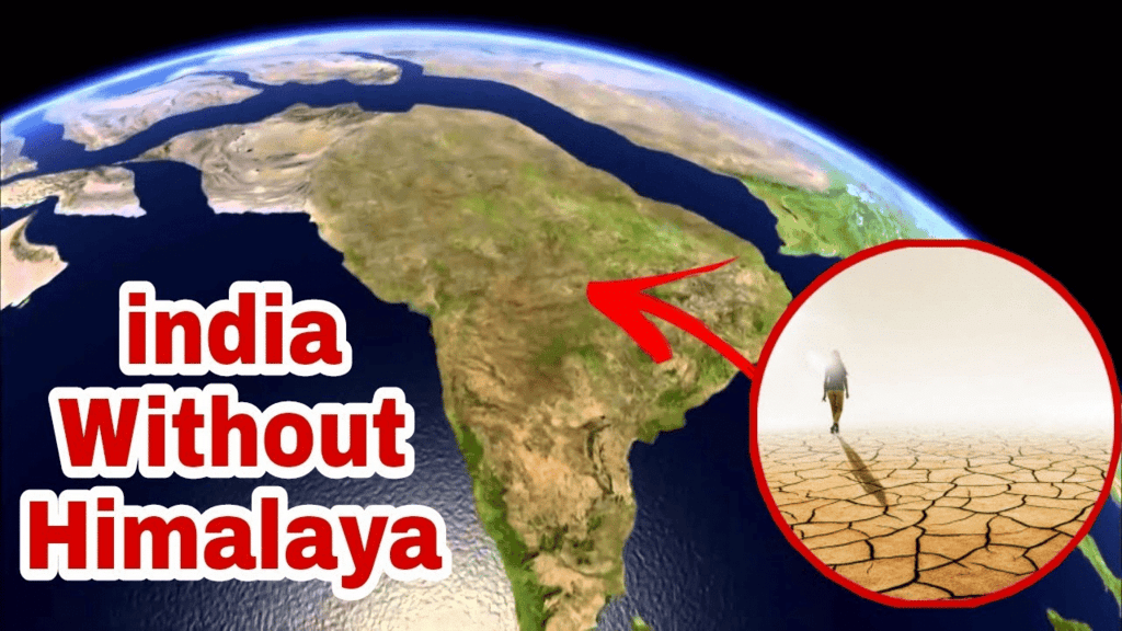
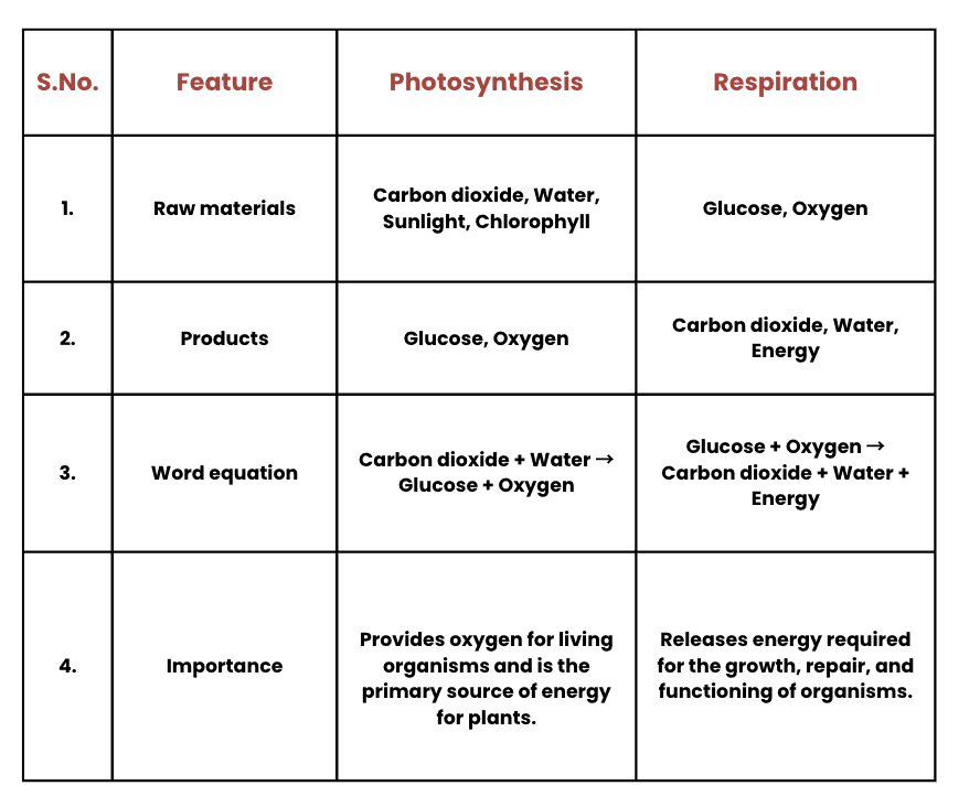
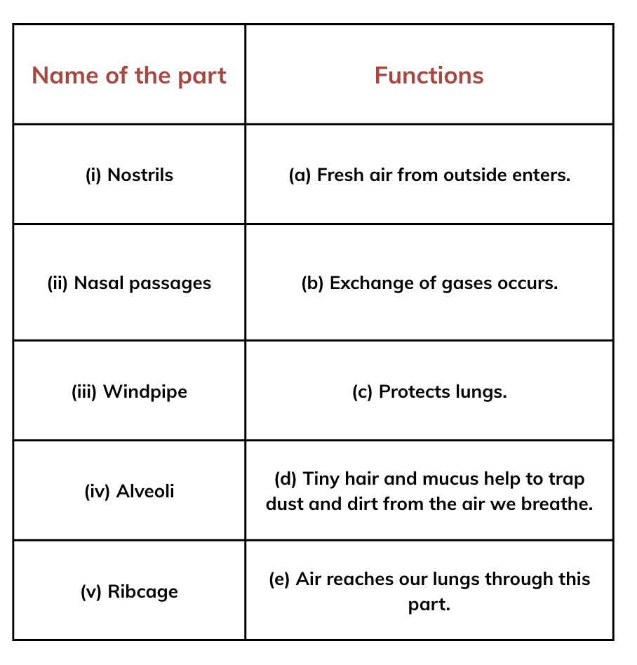
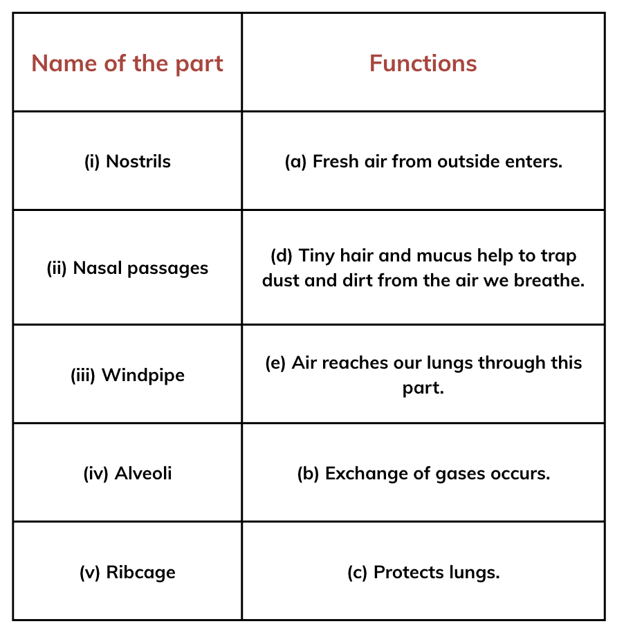
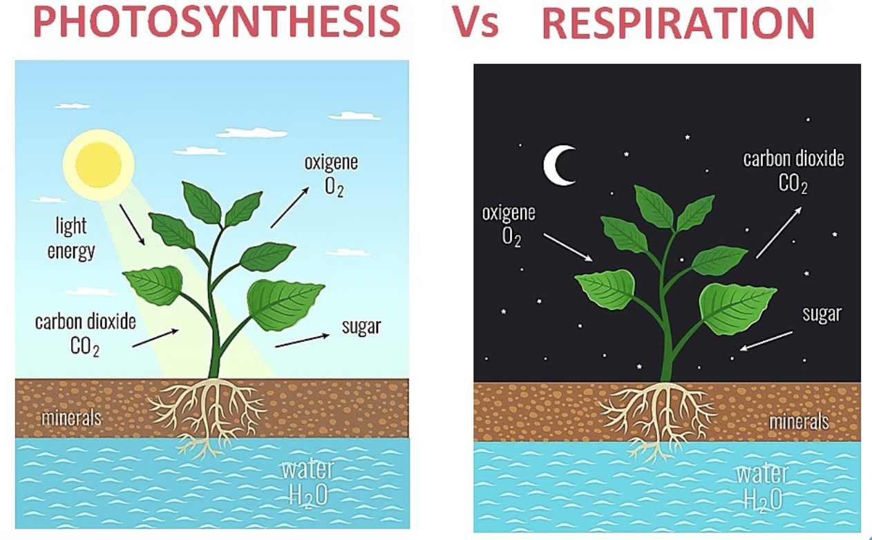
  • Respiration is the process where plants and animals break down glucose to release energy, consuming oxygen and releasing carbon dioxide. This helps maintain oxygen levels and provides carbon dioxide for plants to use in photosynthesis.

Together, these processes ensure a balance of oxygen and carbon dioxide in the atmosphere, which is vital for sustaining life on Earth.

09. Life Processes in Animals  Chapter Solution

Q1: Complete the journey of food through the alimentary canal by filling up the boxes with appropriate parts.

Ans: 

Q2: Sahil placed some pieces of chapati in test tube A. Neha placed chewed chapati in test tube B, and Santushti took boiled and mashed potato in test tube C. All of them added a few drops of iodine solution to their test tubes—A, B, and C, respectively. What would be their observations? Give reasons.
Ans:

  • Test tube A (Pieces of chapati): After adding iodine solution, the color of the mixture will turn blue-black. This is because iodine reacts with starch and turns blue-black. The chapati contains starch, so iodine will show this color change in test tube A.
  • Test tube B (Chewed chapati): The color of the mixture will either show no change or a very faint blue-black color. This is because the chewing process, aided by the saliva, starts breaking down the starch into simpler sugars (like maltose), which do not react with iodine. So, there will either be no starch left or only a small amount in test tube B.
  • Test tube C (Boiled and mashed potato): The color of the mixture will turn blue-black. Potatoes contain starch, and when iodine is added, it will react with the starch and turn blue-black, just like in test tube A.

Reasoning: Iodine solution reacts with starch and turns blue-black. In test tubes A and C, starch is present, which causes the color change. However, in test tube B, due to the breakdown of starch into simpler sugars by chewing, there is less starch left to react with the iodine, resulting in a weaker or no color change.

Q3: What is the role of the diaphragm in breathing?
(i) To filter the air
(ii) To produce sound
(iii) To help in inhalation and exhalation
(iv) To absorb oxygen

Ans:
(iii) To help in inhalation and exhalation.
The diaphragm moves downward during inhalation, expanding the chest cavity, and moves upward during exhalation, pushing air out of the lungs.

Q4: Match the following.

Ans:Q5: Anil claims to his friend Sanvi that respiration and breathing are the same process. What question(s) can Sanvi ask him to make him understand that he is not correct?

Ans:  Sanvi can ask the following questions to make Anil understand the difference between respiration and breathing:

  • “What is the difference between breathing and respiration?”
  • “Does respiration happen even when we are not breathing?”
  • “Can you explain what happens to the food we eat during respiration?”

These questions will help Anil understand that breathing is the physical process of inhaling and exhaling, while respiration is the chemical process where oxygen is used to break down glucose to release energy.

Q6: Which of the following statements is correct and why?
Anu: We inhale air.
Shanu: We inhale oxygen.
Tanu: We inhale air rich in oxygen.

Ans: (iii) Tanu: We inhale air rich in oxygen.
This is the most accurate because the air we breathe contains 21% oxygen, making it “rich in oxygen” for our needs.

Q7: We often sneeze when we inhale a lot of dust-laden air. What can be possible explanations for this?
Ans: When we inhale a lot of dust-laden air, we often sneeze for the following reasons:

1. Nose irritation: Dust can irritate the inside of our nose, causing the body to react by sneezing.

2. Body’s defense: Sneezing helps the body get rid of the dust, protecting the lungs from harmful particles.

3. Cleaning airways: Sneezing clears the dust from our nose and throat, making it easier to breathe.

Q8: Paridhi and Anusha of Grade 7 started running for their morning workout. After they completed their running, they counted their breaths per minute. Anusha was breathing faster than Paridhi. Provide at least two possible explanations for why Anusha was breathing faster than Paridhi.
Ans: Here are two simple reasons why Anusha was breathing faster than Paridhi after their run:

  • Running faster: Anusha may have been running faster or working harder, which makes her body need more oxygen, causing her to breathe faster.
  • Fitness levels: Anusha might not be as fit as Paridhi, so her body has to work harder, making her breathe faster.

In short, Anusha might have run faster or her body needed more oxygen, which made her breathe faster than Paridhi.

Q9: Yadu conducted an experiment to test his idea. He took two test tubes, A and B, and added a pinch of rice flour to the test tubes, half-filled with water, and stirred them properly. To test tube B, he added a few drops of saliva. He left the two test tubes for 35–45 minutes. After that, he added iodine solution into both the test tubes. What do you think he wants to test?
Ans: Observation:

Test Tube A (without saliva): After adding iodine, the water in test tube A will turn blue-black, indicating that starch is present in the rice flour.

Test Tube B (with saliva): After adding iodine, the water in test tube B will show little to no color change (or a lighter blue-black color), suggesting that the starch has been broken down by the enzyme amylase in the saliva.

By performing this experiment, Yadu tested the effect of saliva on the breakdown of starch in rice flour. The iodine test will show whether starch is present in the rice flour, indicating whether it was broken down by the enzymes in the saliva.

Q10: Rakshita designed an experiment taking two clean test tubes, A and B, and filled them with lime water as shown in the figure. In test tube A, the surrounding air that we inhale was passed on by sucking air from the pipe, and in test tube B, the exhaled air was blown through the pipe. What do you think she is trying to investigate? How can she confirm her findings?
Ans: Rakshita is investigating the difference in the amount of carbon dioxide between inhaled and exhaled air. 

She can confirm her findings by inhaling and exhaling from tubes: 

  • Test Tube A (Inhaled air): When the air we breathe in passes through lime water, there will likely be no color change because the air we inhale has very little carbon dioxide.
  • Test Tube B (Exhaled air): When exhaled air passes through lime water, the lime water will turn milky due to the presence of higher carbon dioxide in the exhaled air. Carbon dioxide reacts with lime water to form calcium carbonate, which causes the milkiness.

Conclusion:

By observing whether the lime water in test tube B turns milky, Rakshita can confirm that exhaled air contains more carbon dioxide than inhaled air.

08. Measurement Of Time and Motion Chapter Solution

Q1: Calculate the speed of a car that travels 150 meters in 10 seconds. Express your answer in km/h.

Answer:
Speed = Distance / Time

Given:

  • Distance = 150 meters
  • Time = 10 seconds

Convert meters to kilometers and seconds to hours:

  • 150 meters = 0.15 km
  • 10 seconds = 10/3600 hours = 1/360 hours

Now calculate speed:
Speed = 0.15 km / (1/360 hour) = 0.15 x 360 = 54 km/h

Q2: A runner completes 400 meters in 50 seconds. Another runner completes the same distance in 45 seconds. Who has a greater speed and by how much?

Answer:
Speed = Distance / Time

Runner 1:

  • Distance = 400 meters
  • Time = 50 seconds
  • Speed = 400 / 50 = 8 m/s

Runner 2:

  • Distance = 400 meters
  • Time = 45 seconds
  • Speed = 400 / 45 ≈ 8.89 m/s

Conclusion:
Runner 2 has a greater speed by:
8.89 m/s – 8 m/s = 0.89 m/s

Q3: A train travels at a speed of 25 m/s and covers a distance of 360 km. How much time does it take?

Answer:
Time = Distance / Speed

Convert 360 km to meters:
360 km = 360,000 meters

Now calculate the time:
Time = 360,000 meters / 25 m/s = 14,400 seconds

Convert seconds to hours:
14,400 / 3600 = 4 hours

Q4: A train travels 180 km in 3 hours. Find its speed in:

(i) km/h

(ii) m/s

(iii) What distance will it travel in 4 hours if it maintains the same speed throughout the journey?

Answer:

(i) Speed in km/h:
Speed = Distance / Time = 180 km / 3 hours = 60 km/h

(ii) Speed in m/s:
Convert 180 km to meters:
180 km = 180,000 meters

Now calculate speed in m/s:
Speed = 180,000 meters / (3 hours x 3600 seconds) = 16.67 m/s

(iii) Distance in 4 hours:
Distance = Speed x Time = 60 km/h x 4 hours = 240 km

Q5: The fastest galloping horse can reach the speed of approximately 18 m/s. How does this compare to the speed of a train moving at 72 km/h?

Answer:
Convert the speed of the train to m/s:
72 km/h = 72 x 1000 meters / 3600 seconds = 20 m/s

Comparison:
The horse moves at 18 m/s.
The train moves at 20 m/s.

Conclusion:
The train is faster than the galloping horse by:
20 m/s – 18 m/s = 2 m/s

Q6: Distinguish between uniform and non-uniform motion using the example of a car moving on a straight highway with no traffic and a car moving in city traffic.

Answer: Uniform motion
When a car moves on a straight highway with no traffic, it maintains a constant speed. This is uniform motion, where the distance covered in equal time intervals is the same.

Non-uniform motion
In city traffic, the car’s speed changes due to stops, slowdowns, and accelerations. This is non-uniform motion, where the distance covered in equal intervals of time is not constant.

Q7: Data for an object covering distances in different intervals of time are given in the following table. If the object is in uniform motion, fill in the gaps in the table.

Answer: Check for uniform motion: 

Keeping in mind , this is an uniform motion, the object must cover equal distances in equal time intervals.

Therefore, 

Q8: A car covers 60 km in the first hour, 70 km in the second hour, and 50 km in the third hour. Is the motion uniform? Justify your answer. Find the average speed of the car.

Answer:
Since the car covers different distances in each hour (60 km, 70 km, and 50 km), the motion is non-uniform.

To find the average speed:
Total distance = 60 km + 70 km + 50 km = 180 km
Total time = 3 hours
Average speed = Total distance / Total time = 180 km / 3 hours = 60 km/h

Q9: Which type of motion is more common in daily life—uniform or non-uniform? Provide three examples from your experience to support your answer.

Answer:
Non-uniform motion is more common in daily life. Examples:

  1. A car in city traffic: The car’s speed changes due to stops and accelerations.
  2. A bicycle in a park: The rider’s speed changes while turning or stopping.
  3. People walking: Walking speed varies due to obstacles or fatigue.

Q10: Data for the motion of an object are given in the following table. State whether the speed of the object is uniform or non-uniform. Find the average speed.

Answer: Check the distance traveled in each time interval:

As the distances covered in each interval are not equal, the motion is non-uniform.

Average Speed = Total Distance / Total Time

Total distance = 60 m (final distance)

Total time = 100 s (final time)

Average Speed = 60 m / 100 s = 0.6 m/s

Q11: A vehicle moves along a straight line and covers a distance of 2 km. In the first 500 m, it moves with a speed of 10 m/s and in the next 500 m, it moves with a speed of 5 m/s. With what speed should it move the remaining distance so that the journey is complete in 200 s? What is the average speed of the vehicle for the entire journey

Answer: Given-

  1. Total distance = 2 km = 2000 meters
  2. First part of the journey: Distance = 500 meters, Speed = 10 m/s
  3. Second part of the journey: Distance = 500 meters, Speed = 5 m/s
  4. Total time for the journey = 200 seconds

Calculate the time taken for the first two parts of the journey

1. For the first 500 meters (speed = 10 m/s):
Time = Distance / Speed = 500 meters / 10 m/s = 50 seconds

2. For the next 500 meters (speed = 5 m/s):
Time = Distance / Speed = 500 meters / 5 m/s = 100 seconds

Calculate the remaining time for the last 1000 meters

The total time allowed is 200 seconds, and the time spent on the first two parts of the journey is:
Time spent = 50 seconds + 100 seconds = 150 seconds

Thus, the time remaining for the last 1000 meters is:
Remaining time = 200 seconds – 150 seconds = 50 seconds

Calculate the required speed for the remaining 1000 meters

Now, we need to cover the remaining 1000 meters in 50 seconds. 

The required speed is:
Speed = Distance / Time = 1000 meters / 50 seconds = 20 m/s

Calculate the average speed for the entire journey

The average speed for the entire journey is given by:
Average speed = Total distance / Total time
Total distance = 2000 meters, and total time = 200 seconds, so:
Average speed = 2000 meters / 200 seconds = 10 m/s