IntroductionIndia’s climate is one of the most diverse and complex in the world. It is shaped by various factors that create different weather patterns across the vast country. In this chapter we will explore:
Diverse Climate
- Why India’s climate is diverse.
- What monsoons are.
- How climate affects the economy, culture, and society.
- How understanding climate helps prepare for natural disasters.
- An explanation of climate change and its consequences.
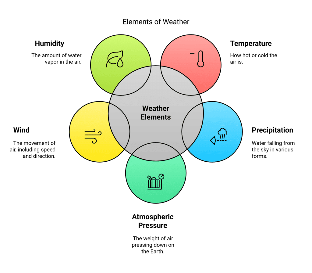
Weather, Seasons, and the Climate
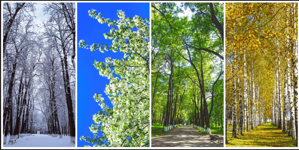
Weather is the daily condition of the atmosphere, like rain, sunshine, or wind, and it changes often. Climate is the average weather pattern in an area over many years (decades). Seasons are periods in a year, like spring, summer, autumn, and winter, that repeat annually.
Weather of India
- Most parts of the world have four main seasons—spring, summer, autumn, and winter.
- In India, besides these, there is a special season called the monsoon or rainy season, making a total of five main seasons.
- Traditionally, India divides the year into six seasons or ritus: vasanta (spring), grishma (summer), varsha (rainy), sharad (autumn), hemanta (pre-winter), and shishir (winter).
- Each season has festivals, like Vasanta Panchami in spring or Sharad Purnima in autumn.
- The weather changes with each season—for instance, it is hot and dry in summer, and humid and rainy during the monsoon. The seasonal pattern in a region forms a key part of its climate.
- Plants, animals, and humans all adjust to these seasonal rhythms. Crops grow in specific seasons, many trees shed their leaves or change colors in autumn, and animals grow thick fur to survive the cold winter months.
- While climate generally remains stable over long periods, scientists have noted changes in recent decades, with many of these changes caused by human activities.
Try yourself:
What is the average weather pattern in an area over many years called?
- A.Monsoon
- B.Season
- C.Climate
- D.Weather
View SolutionTypes of Climates in India
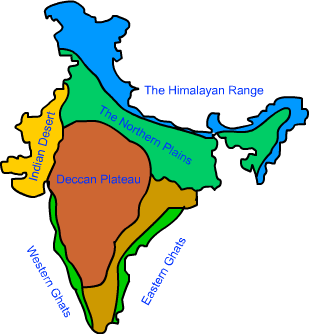
India is a land of diverse climates, varying greatly across different regions:
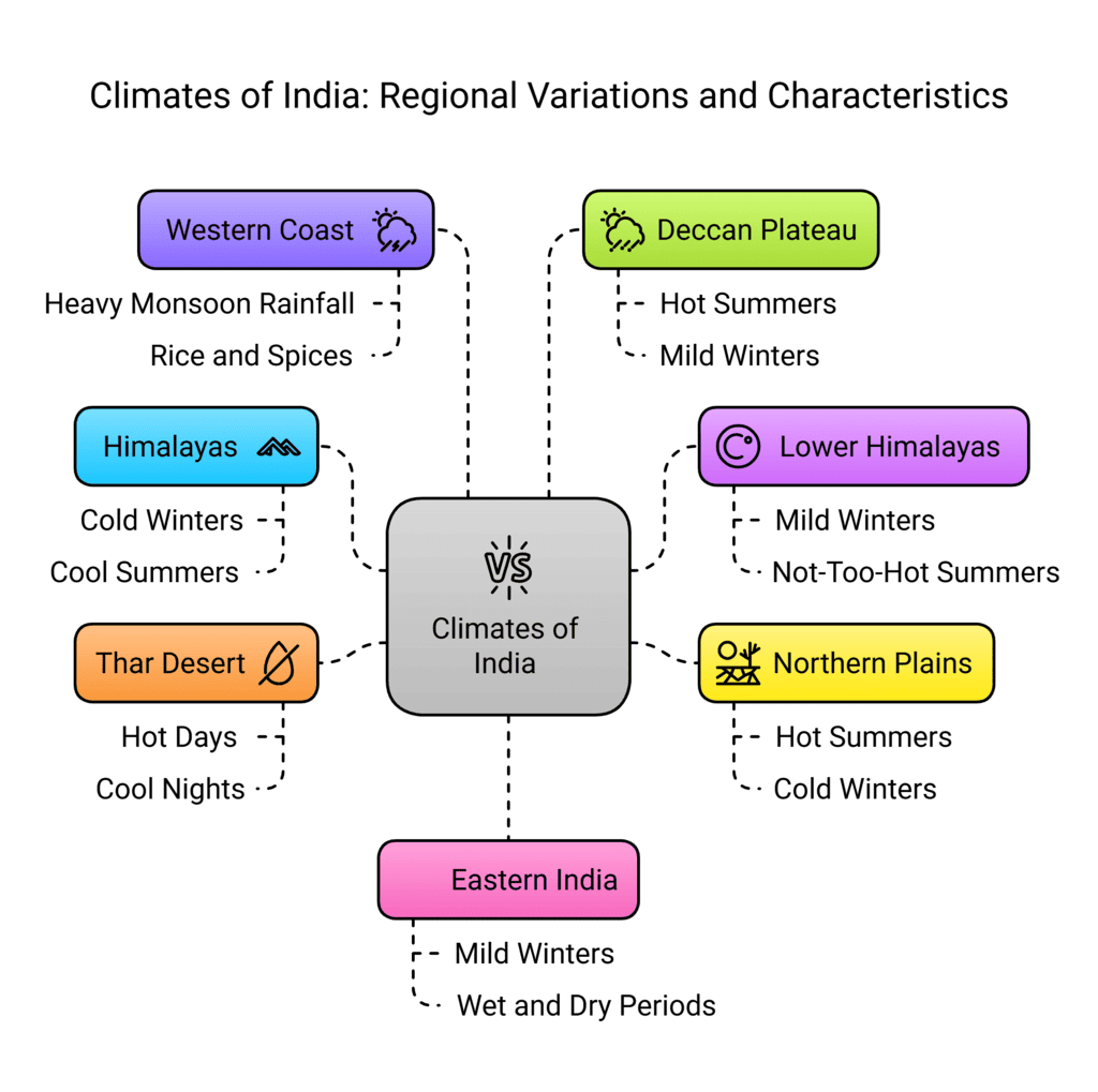
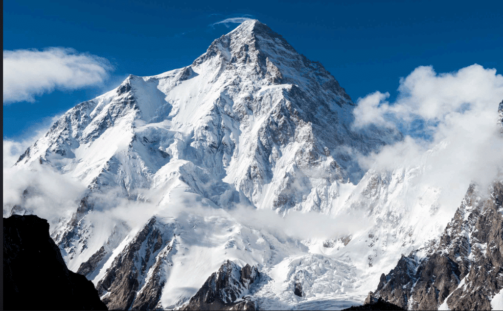
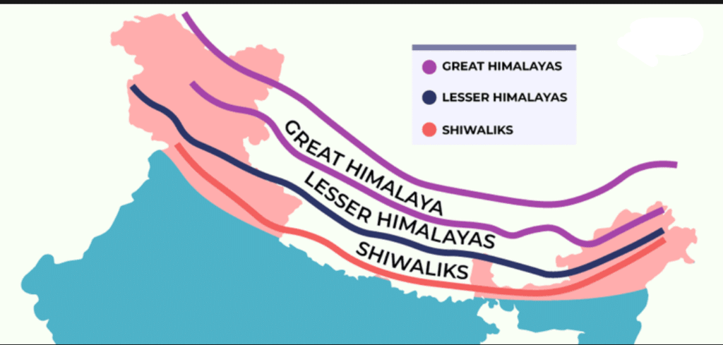
Himalayan Mountains (North):
- Have an alpine climate with cold, snowy winters and cool summers.
- The term “alpine” originates from the Alps mountains in Europe.
- This region requires the thickest clothing in India due to cold weather.
Lower Himalayas and Hill Areas:
- Experience a temperate climate with moderately cold winters and mild summers.
- Popular for many hill stations where people visit to escape the heat of the plains.
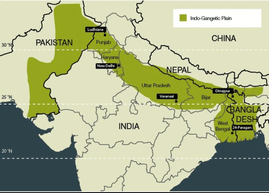
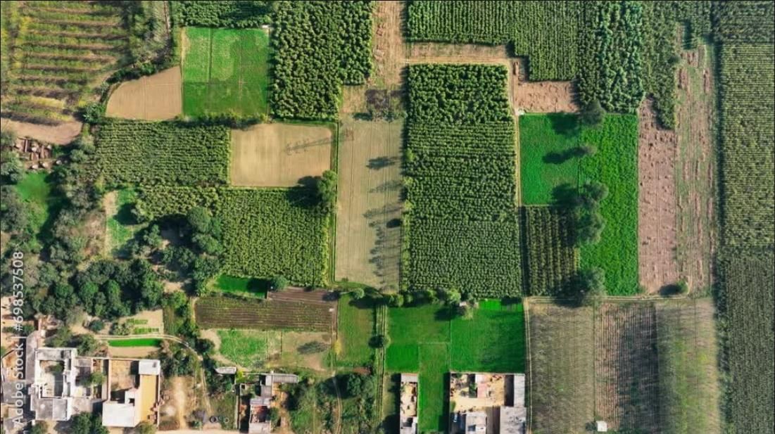
Northern Plains:
- Have a subtropical climate with very hot summers and cold winters.
- This region is the main area for growing wheat.
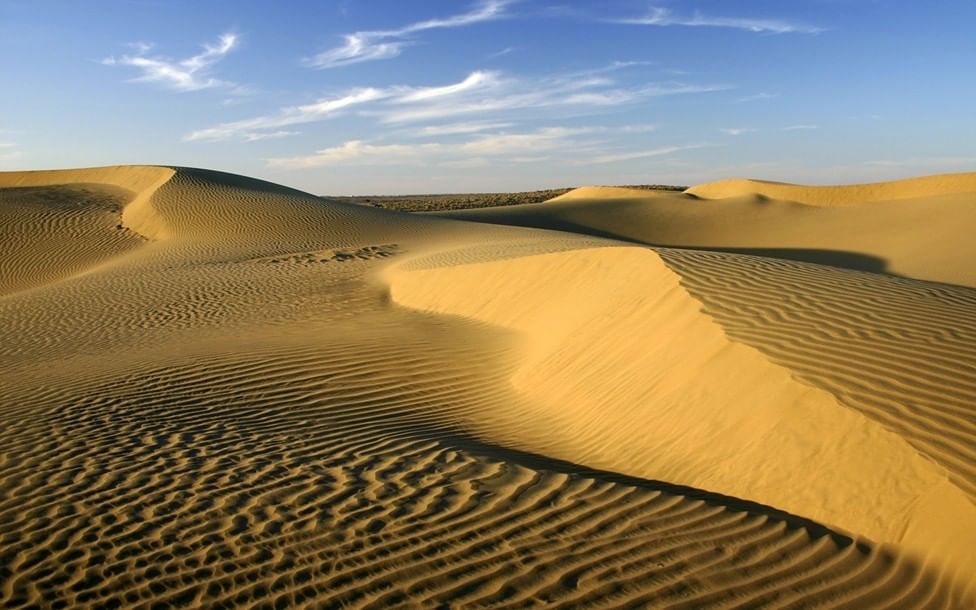
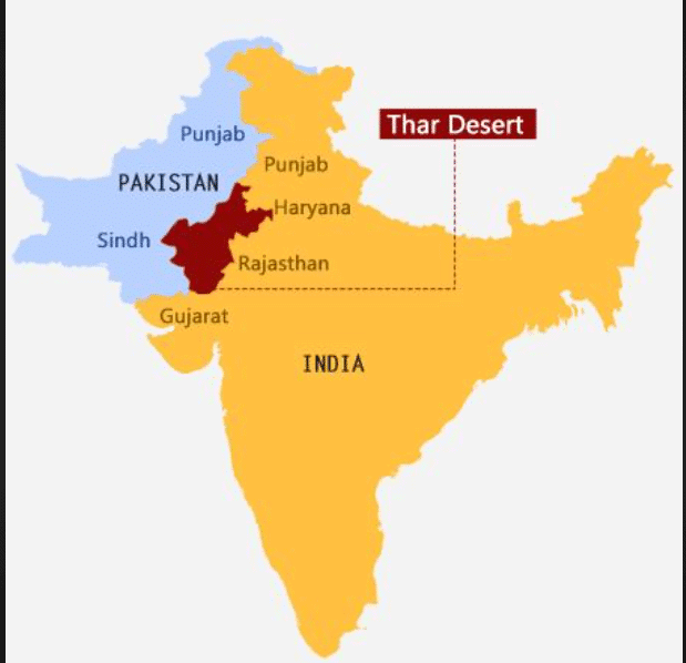
Thar Desert (West):
- Characterized by an arid climate with extremely hot days, cool nights, and very little rainfall.
- Inhabitants have developed unique methods to collect and conserve water.
Thar DesertWestern Coastal Strip:
- Receives heavy rainfall during the monsoon months.
- Has a tropical wet climate that supports the cultivation of rice and spices.
Central Deccan Plateau:
- Experiences a semi-arid climate with hot summers, mild winters, and moderate rainfall during the rainy season.
Eastern India and Southern Peninsula:
- Experience a tropical climate with mild winters and distinct wet and dry periods controlled by monsoon winds.
Try yourself:
What type of climate is found in the Thar Desert?
- A.Temperate
- B.Tropical wet
- C.Alpine
- D.Arid
View SolutionFactors Determining the Climate
Several factors shape India’s climates, including global, regional, and local ones:a) Latitude:
- Latitude measures distance from the Equator. Near the Equator (low latitudes), it’s hot; near the poles (high latitudes), it’s cold.
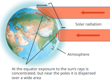
Effect of Latitude
- At the Equator, the sun’s rays hit directly, focusing heat on a small area. At the poles, rays are slanted, spreading heat over a larger area and passing through more atmosphere, reducing heat.
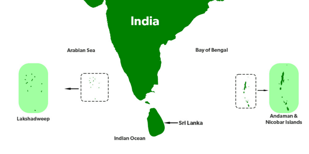
- In India, Kanyakumari and Nicobar Islands (near Equator) are warm year-round, while Srinagar (farther north) is cooler.
b) Altitude:
- Higher places like hill stations (e.g., Ooty, Shimla) are cooler than lowlands.
- Temperature drops as altitude increases because air is less dense and farther from the Earth’s warm surface.
- Himalayan peaks are so high they stay below freezing, keeping snow year-round.
- Example: Ooty (10–25°C in summer) is cooler than Coimbatore (25–38°C) at the same latitude due to higher altitude.
c) Proximity to the Sea:
- Coastal areas have milder temperatures because the sea keeps summers cooler and winters warmer.
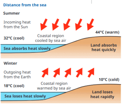
Distance from Sea
- Inland areas have extreme temperatures (hotter summers, colder winters).
- Example: Mumbai (coastal, 32°C summer, 18°C winter) has a smaller temperature range (14°C) than Nagpur (inland, 44°C summer, 10°C winter, 34°C range).
d) Winds:
- Winds carry warm or cool air, affecting temperature and humidity.
Winds
- Hot, dry winds from Arabian deserts cause heat waves in Punjab, Haryana, Rajasthan, and Madhya Pradesh in summer.
- Cold winds from the Himalayas bring cold waves to northern foothills in winter.
- Sea winds bring moisture, leading to rainfall.
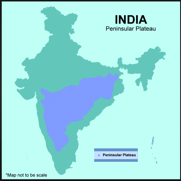
e) Topography:
- The shape of the land affects climate. The Himalayas and Karakoram block cold desert winds from Central Asia.
- The flat Thar Desert has no protection from hot, dry winds.
- The Western Ghats influence monsoon rainfall.
What is Microclimate?
- A small area’s climate that differs from the surrounding region.
- Examples: enclosed valleys, forests, or urban heat islands (cities with many buildings and little greenery that trap heat).
- Microclimates affect local plants, animals, crops, and human health.
Try yourself:
What is a microclimate?
- A.A seasonal change in temperature
- B.A climate experienced only in forests
- C.A type of weather pattern in urban areas
- D.A small area’s climate that differs from the surrounding region
View SolutionThe Monsoons
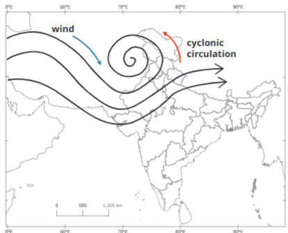
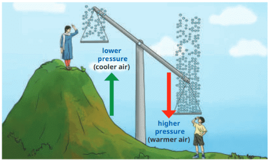
The monsoon season is vital for India, filling rivers, watering soil, and growing crops. The word “monsoon” comes from Arabic “mausim” (season) and refers to seasonal winds over the Indian Ocean and South Asia. Monsoons happen because land heats and cools faster than the ocean, creating pressure differences that drive winds.
Monsoons
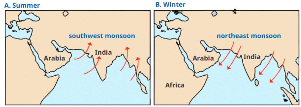
Summer Monsoon(Southwest Monsoon):
- In summer, the Asian landmass heats up, creating a low-pressure system.
- Cooler, high-pressure ocean air flows to the land, carrying moisture that falls as heavy rain.
- Starts in early June at India’s southern tip, reaching the whole country by mid-July.
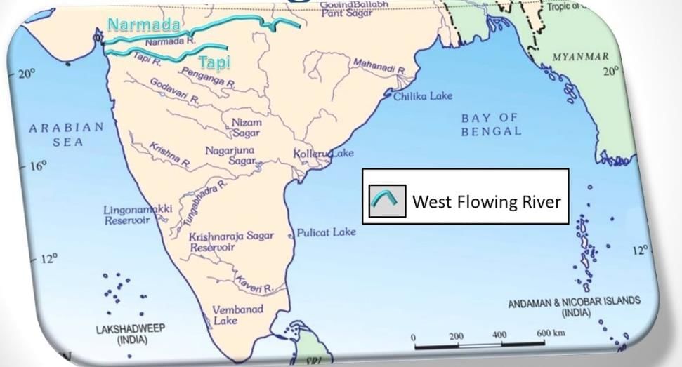
- The Western Ghats block winds, causing heavy rain on their western slopes but less on the Deccan Plateau.
Winter Monsoon(Northeast Monsoon):
- In winter, the land cools faster, creating a high-pressure system, while the ocean stays warmer with lower pressure.
- Winds blow from land to sea, bringing dry weather to most of India.
- Some winds over the Bay of Bengal pick up moisture, causing rain in east and south India.
Some Interesting Facts on Monsoon in India
- Mawsynram in Meghalaya gets the world’s highest rainfall, about 11,000 mm yearly.
- Monsoons inspire music, like ragas Meghamilhar and Amruthavarshini.
- Traditional knowledge predicts monsoons, e.g., fish surfacing on the Konkan coast or Golden Shower trees blooming 50 days before rain.
Climate and Our Lives
Climate shapes our culture, economy, and daily life. Many Indian festivals, like Baisakhi and Onam, are tied to seasons and farming, celebrating harvests or rain.
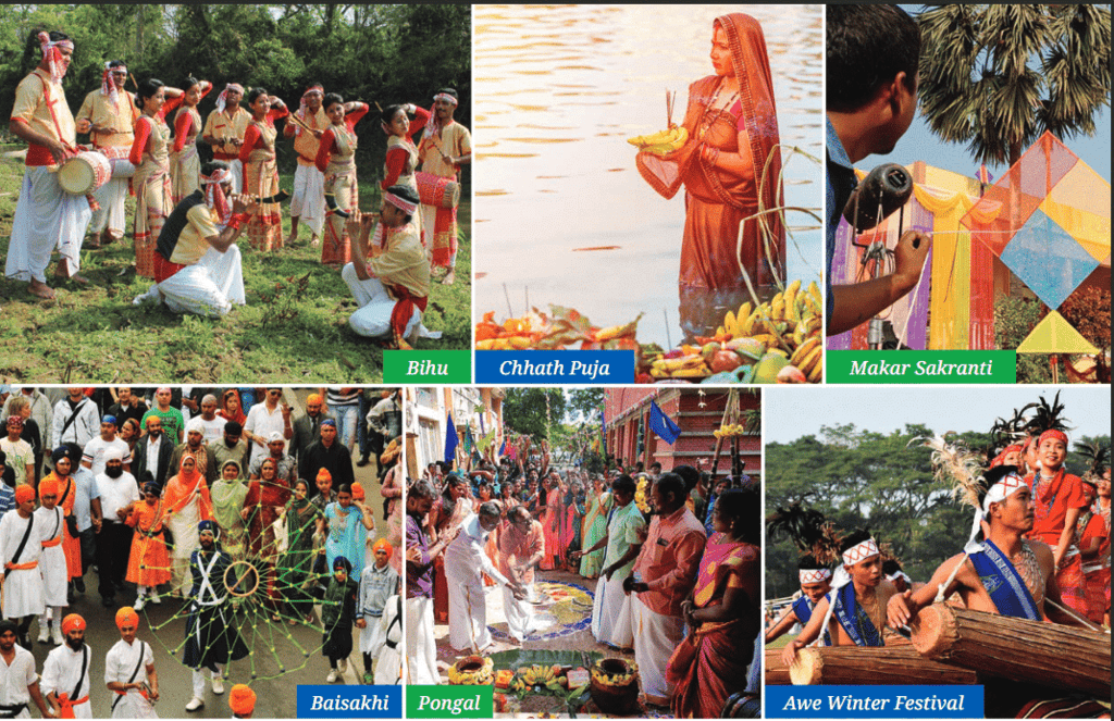
Harvest Festivals of IndiaClimate affects the economy:
- A monsoon failure (poor rainfall) hurts farming, reduces food supply, raises prices, and forces workers to move to cities.
- Industries need predictable weather and water to function.
- Traditional dances, songs, and rituals are linked to seasons and rain, passed down by elders.
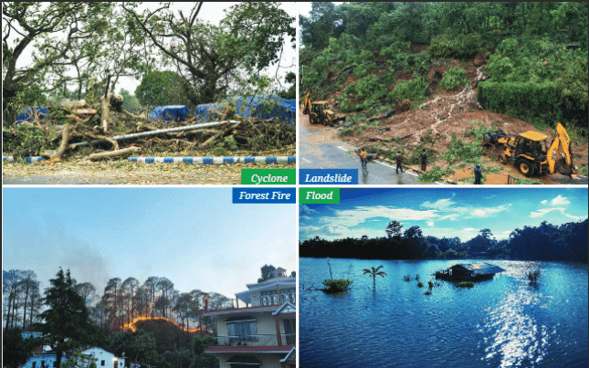
Climates and Disasters
India’s diverse climates can cause extreme weather, leading to natural disasters like cyclones, floods, landslides, and forest fires.
Disasters
a) Cyclones:
- Common on the eastern coast, caused by intense low-pressure systems over the sea.
- Moist sea air forms clouds that rotate around a calm center called the eye of the cyclone.
- They destroy homes, trees, and infrastructure, and cause soil erosion.
- The India Meteorological Department (IMD) tracks cyclones to warn people.
- The National Disaster Response Force (NDRF) helps with rescue during cyclones.
b) Floods:
- Happen when water overflows onto dry land, often during monsoons in states like Uttar Pradesh, Bihar, Kerala, Andhra Pradesh, and Assam.
- Caused by heavy rain, overflowing rivers, or poor drainage in cities.
- In the Himalayas, glacial bursts from melting glaciers or heavy rain cause floods.
- Example: In 2013, Uttarakhand’s Kedarnath floods from a glacial burst killed about 6,000 people and destroyed villages.
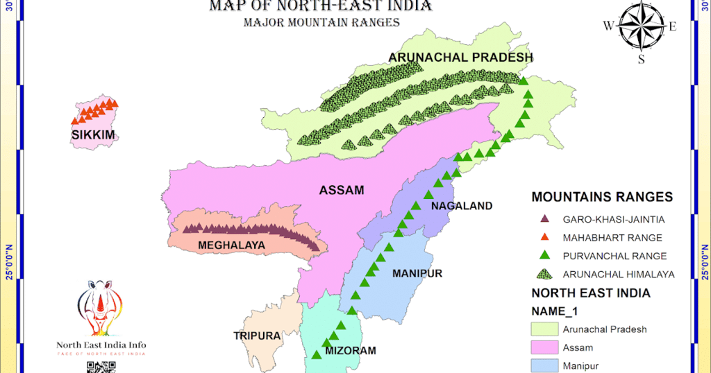
c) Landslides:
- Sudden collapse of rock or soil in hilly areas like Himachal Pradesh, Uttarakhand, Sikkim, Arunachal Pradesh, and the Western Ghats.
- Triggered by heavy rain, earthquakes, or human activities like deforestation or poor construction.
d) Forest Fires:
- Uncontrolled fires in forests or grasslands, common in Uttarakhand, Himachal Pradesh, Madhya Pradesh, Chhattisgarh, and the Western Ghats.
- Caused by dry weather, droughts, high winds, or human carelessness.
- They destroy forests, harm wildlife, pollute air, and displace people.
Try yourself:What common natural disaster is caused by intense low-pressure systems over the sea?- A.Forest Fires
- B.Cyclones
- C.Landslides
- D.Floods
Climate Change
Climate change is a long-term shift in climate patterns, like changes in temperature or rainfall. In the past, it was caused by natural processes, but since the 19th century, human activities drive it.
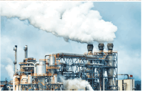
Pollution
Main causes:
- Burning fossil fuels (coal, oil, gas) releases greenhouse gases like carbon dioxide (CO₂).
- Deforestation removes trees that absorb CO₂.
- Harmful industrial practices and wasteful consumption.
Effect of Greenhouse gases:
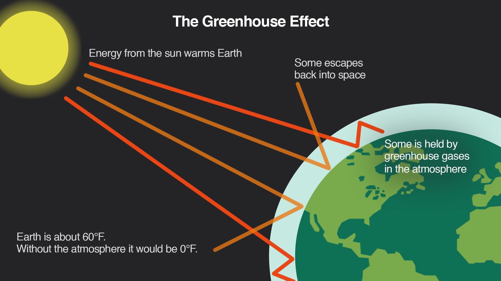
Effect of Greenhouse gases
- Greenhouse gases trap heat, causing global warming, which disrupts climate patterns.
- In India, temperatures rose 1–3°C above normal in early 2025, shortening winter and affecting farming and small industries.
- Consequences include more extreme weather, crop failures, and challenges for communities.
Solutions:
- Solutions include mitigation (reducing emissions, planting trees, using renewable energy) and building resilience to adapt to changes.
- Governments promote sustainable practices, but economic growth often conflicts with these efforts.
Points to Remember
- India’s diverse climate is shaped by its geography, including mountains, deserts, and plateaus.
- Weather changes daily, seasons repeat yearly, and climate is a long-term pattern.
- Factors like latitude, altitude, proximity to the sea, winds, and topography determine climate.
- Monsoons are crucial for farming, bringing rain in summer and in some areas during winter.
- Climate affects culture, festivals, farming, and the economy.
- Understanding climate helps prepare for natural disasters like cyclones, floods, landslides, and forest fires.
- Climate change is causing extreme weather and is driven by human actions, like burning fossil fuels.
Difficult Words
- Climate: The average weather pattern in an area over many years.
- Seasons: Periods in a year, like summer or winter, that repeat annually.
- Monsoon: Seasonal winds that bring heavy rain, especially in summer.
- Latitude: Distance from the Equator, affecting how hot or cold a place is.
- Altitude: Height above sea level, making higher places cooler.
- Topography: The shape and features of the land, like mountains or plains.
- Microclimate: A small area’s unique climate, different from nearby areas.
- Cyclone: A storm with strong winds and rain caused by a low-pressure system.
- Flood: Water overflowing onto dry land, often from heavy rain.
- Landslide: Sudden collapse of rock or soil in hilly areas.
- Forest Fire: Uncontrolled fire in forests or grasslands.
- Climate Change: Long-term shifts in climate patterns, often caused by human actions.
- Fossil Fuels: Energy sources like coal, oil, and gas formed from ancient plants and animals.
- Greenhouse Gases: Gases like CO₂ that trap heat, causing global warming.
 View Answer

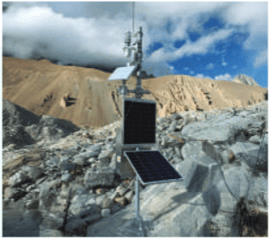 AWS at a Glacial Lake of Sikkim
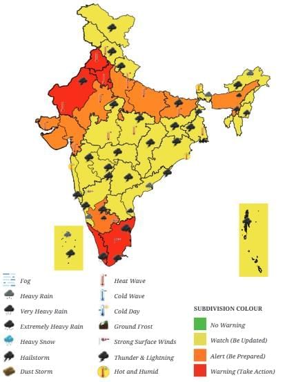
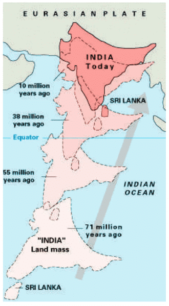 India’s collision with Eurasia around 50 million years ago formed the Himalayas.
 View Answer
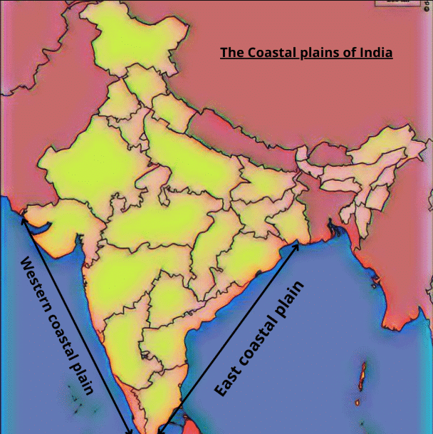

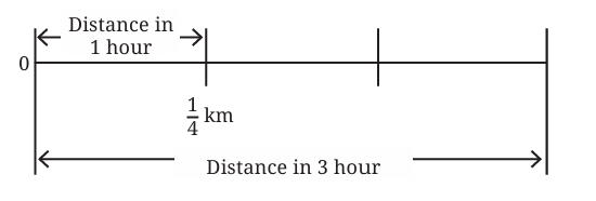
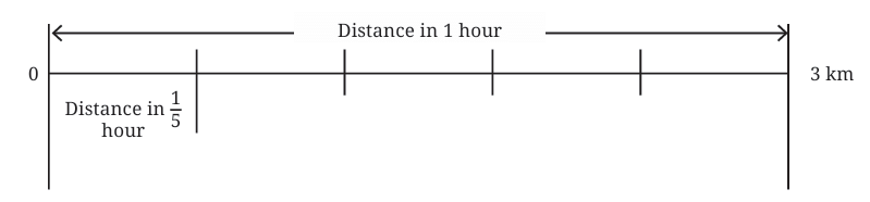
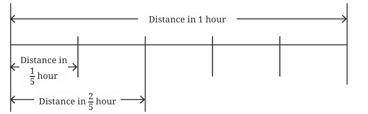
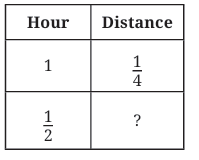
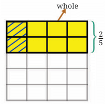 Start with the distance the tortoise covers in 1 hour: 2/5 km.
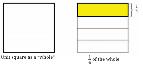
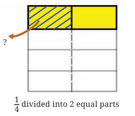
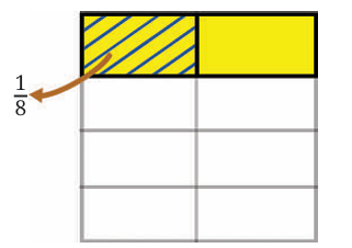 Breadth = 1/4 unit
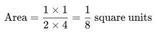
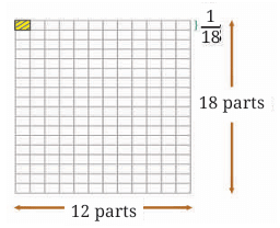
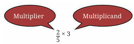
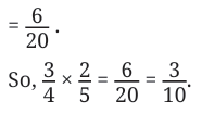
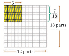
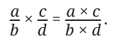
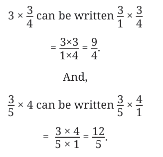
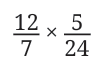
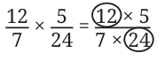
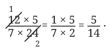
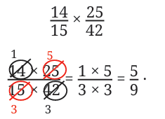
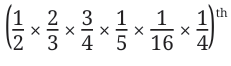
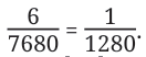
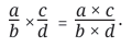
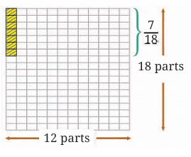 Then, you multiply the denominators:
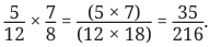
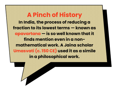


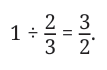

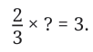
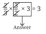
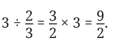

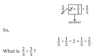

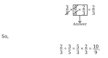
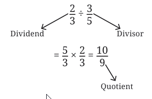
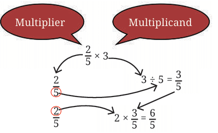
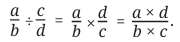 Division: “The division of fractions is performed by interchanging the numerator and denominator of the divisor; the numerator of the dividend is then multiplied by the (new) numerator, and the denominator by the (new) denominator.”
 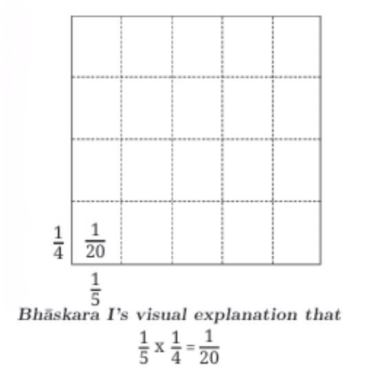 Other Indian Mathematicians: Many others like Shridharacharya (c. 750 CE), Mahaviracharya (c. 850 CE), Caturveda Prithudakasvami (c. 860 CE), and Bhaskara II further developed the use of arithmetic fractions.
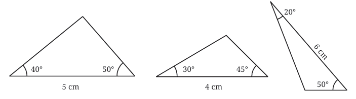
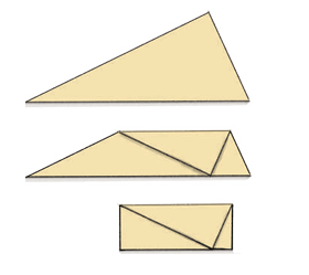
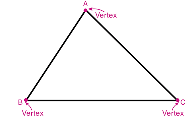 Three Vertices: These are the corner points where the sides intersect. Think of them as the ‘tips’ of the triangle.
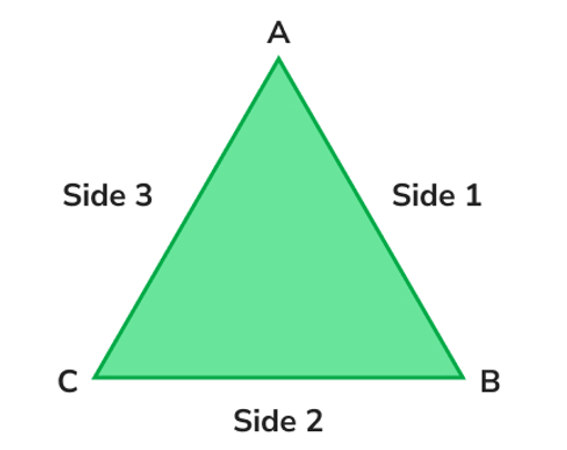 Three Sides: These are the straight line segments connecting each pair of vertices. They form the boundary of the triangle.
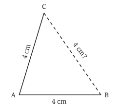
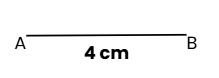 Draw the Base: Use your ruler to draw a line segment AB that is 4 cm long.
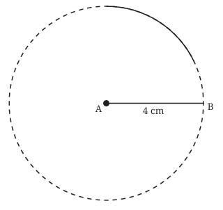 Draw the First Arc: Place the compass point on vertex A. Adjust the compass width to 4 cm (the desired side length). Draw a long arc above the base line. The third vertex, C, must lie somewhere on this arc because every point on this arc is exactly 4 cm away from A
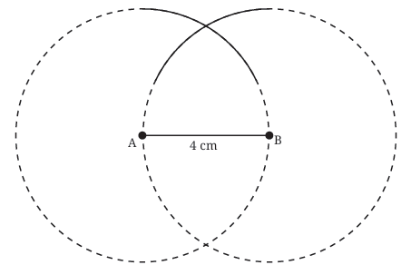 Draw the Second Arc: Now, without changing the compass width (keep it at 4 cm), place the compass point on vertex B. Draw another arc that intersects the first arc. Let the point where the arcs intersect be C.
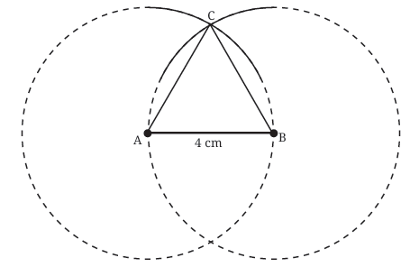 Join the Vertices: Use your ruler to draw straight lines connecting A to C and B to C.
 Label the ends as A and B.
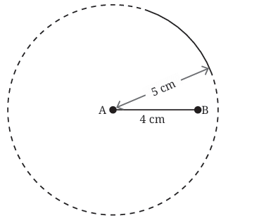 From point A, draw an arc with radius 5 cm. This arc shows all the places where point C (the third corner of the triangle) could be, if it’s 5 cm from A.
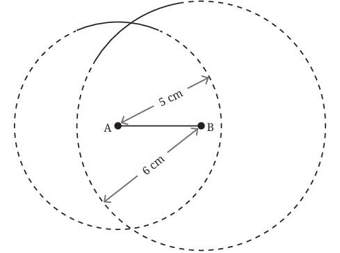 From point B, draw another arc with radius 6 cm. This arc shows where C could be if it’s 6 cm from B.
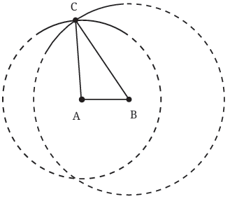 The place where the two arcs cross is the point C. This point is exactly 5 cm from A and 6 cm from B — just like we need.
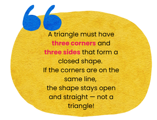
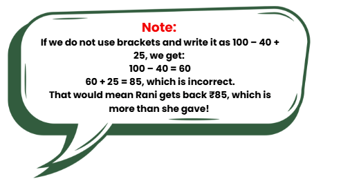
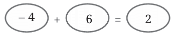
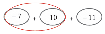
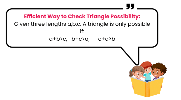 For example: 3 + 4 = 7 < 8 → Not possible
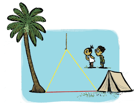 Or walking from the tent to a pole, then from the pole to the tree (longer path).Triangle Inequality Example
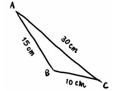 10 + 15 = 25 < 30 → ❌ Not valid
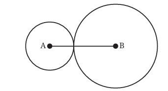
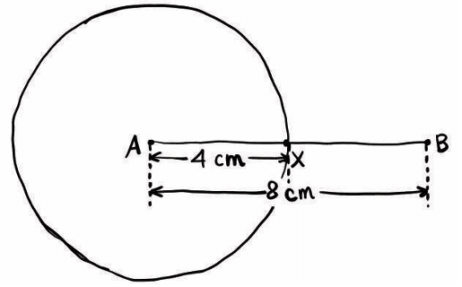 Every point on this circle is 4 cm away from A. This circle shows all the places where point X could be, such that AX = 4 cm.
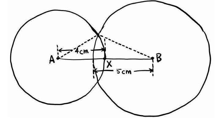
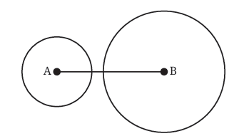 Case 2: Circles do not intersect
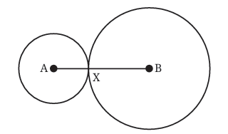
 ∠A = 45°
 Join point B to point C – Now you have triangle ABC.
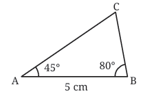 ∠B = 80°
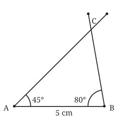 Now, join AC and BC — you have your triangle ABC!
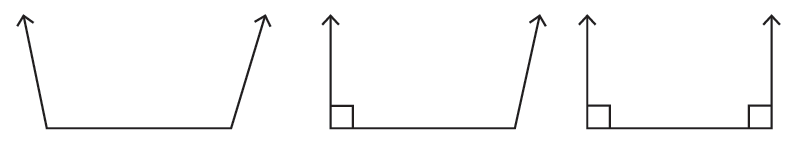
 ∠ACB=70°
 Folding the Angles: Next, you fold the triangle along its edges. The key idea is to fold each corner (or vertex) of the triangle so that each angle aligns with one another. When you do this, all three angles of the triangle will meet at a single point.
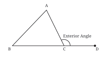
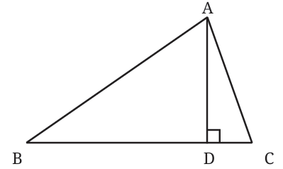 The length of this line, AD, is the altitude of vertex A from the side BC.
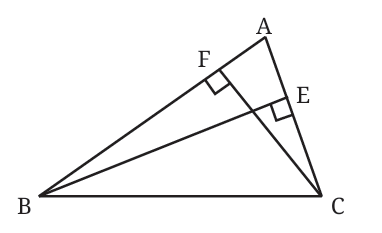
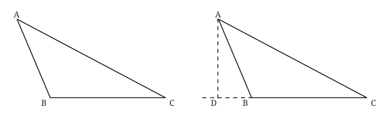 In obtuse triangles (one angle greater than 90°), altitudes might need to be extended outside the triangle, as seen in the figure given below. This is shown by extending the side BC and drawing a perpendicular from A to this extended line.
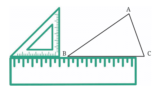
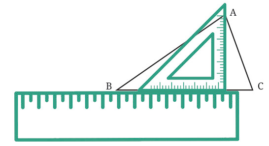 Put the set square on the ruler so that one of its right-angle edges is touching the ruler. This way, we’re guaranteed that one side of the set square forms a perfect 90° angle.
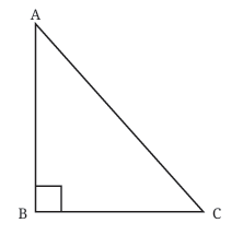
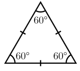
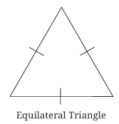 All three angles are also equal, and each angle measures 60°.
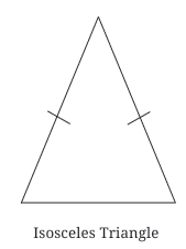 The two angles opposite these equal sides are also equal.
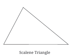 All three angles are different from each other.
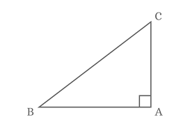 The other two angles are acute (less than 90°).Right-angled Triangle
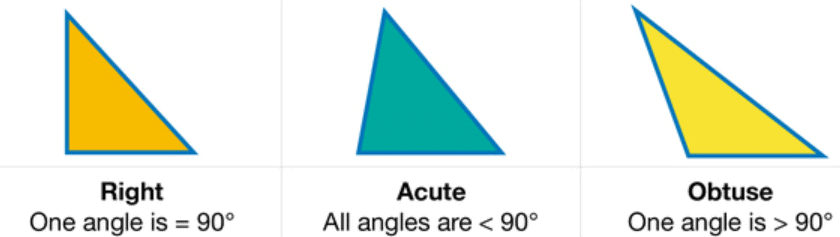 The other two angles will be acute because the total sum of angles in any triangle must always be 180°.

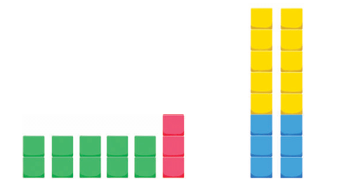
 Even numbers: Can be grouped in pairs with no leftovers. Example: 2, 4, 6, 8, 10…No pair is left
 Odd numbers: Always leave one unpaired object. Example: 1, 3, 5, 7, 9…One unpaired leftWhat happens when you add two odd numbers?
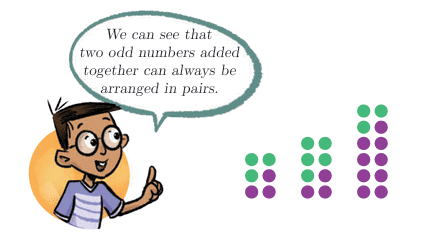 The sum of two odd numbers can always be arranged in pairs, meaning the sum is even.
 A 3 × 4 grid has 12 squares (even).
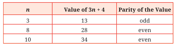 If n is even, 3n is even, 3n + 4 (even + even) is even.
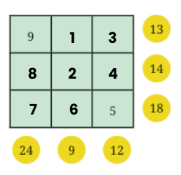
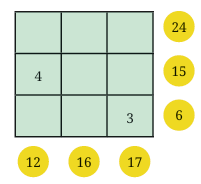
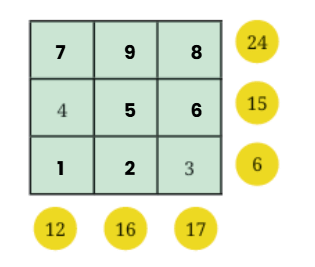
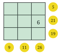
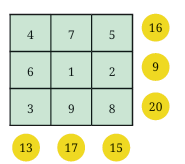
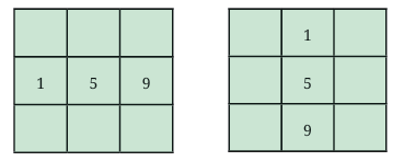
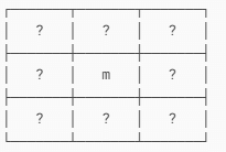
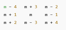
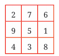
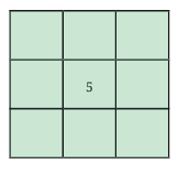 The number 5 must be at the center of the magic square.
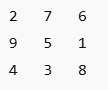

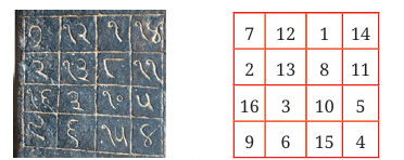
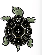
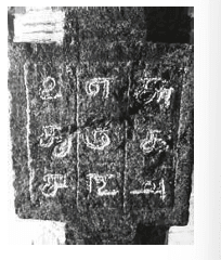 One such 3 × 3 magic square is found on a pillar in a temple in Palani, Tamil Nadu, dating back to the 8th century CE.
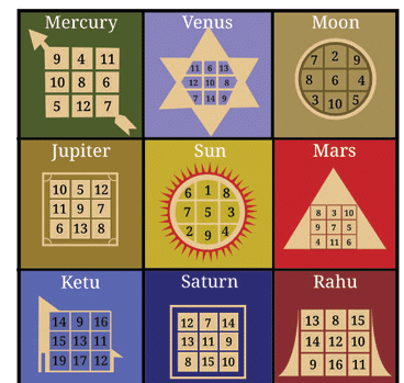 Magic squares are also found in homes and shops, especially in the Navagraha Yantra, which connects magic squares with planets like:
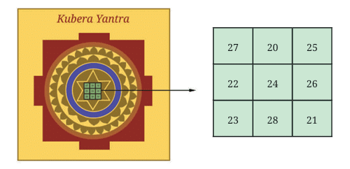


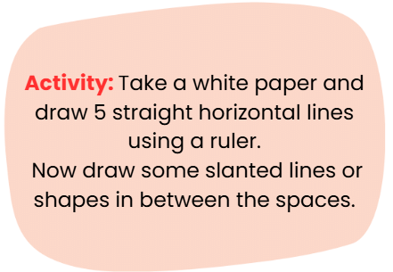
 First Fold: Fold the sheet horizontally exactly in half. You’ve created a new line (crease) in the middle.
 More Folds: Make another horizontal fold in the already folded sheet.
  Vertical Fold: Now, unfold the paper back to the original square. Make a vertical fold down the middle. How does this new vertical line relate to the horizontal lines you made earlier?
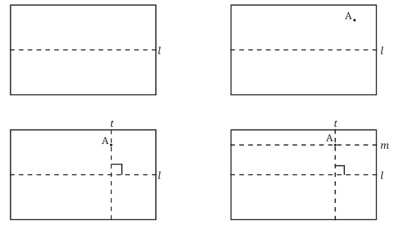
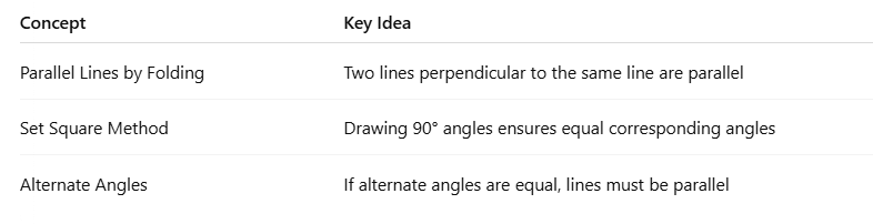
 Perpendicular Lines: We draw a small square symbol at the point of intersection where the right angle (90°) is formed.Representation of Parallel and Perpendicular Lines
 Call this new crease m.
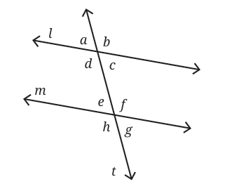

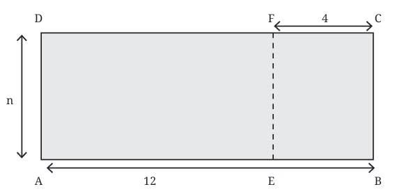
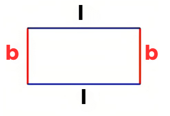 Perimeter formula: Add all sides of the rectangle
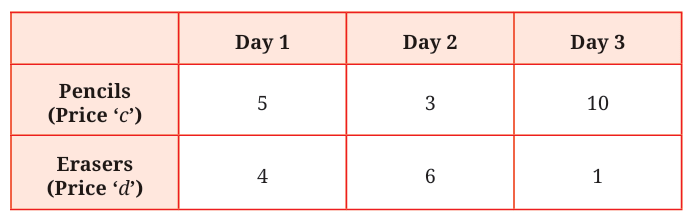 A table gives the number of pencils and erasers sold over 3 days:
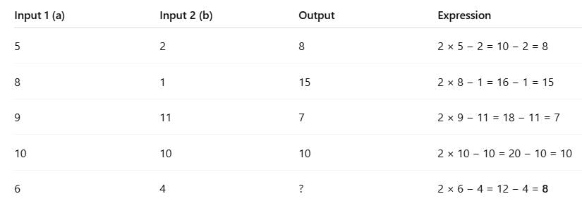
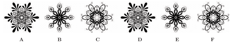
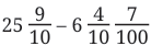
 Look at the remainder


 Yes, one screw was bit longer than the other
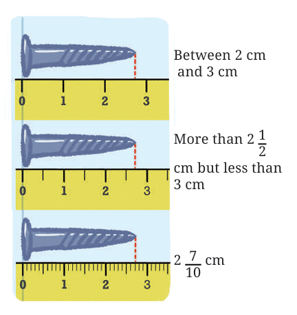


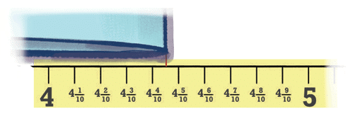
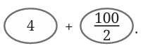
 is read as “four and one-tenth”
 is read as “forty-one and one-tenth”


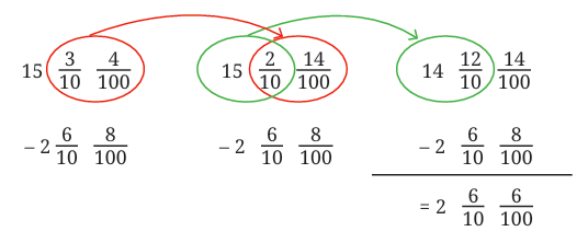
 The other is marked in quarters (¼, ½, ¾…)
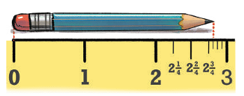

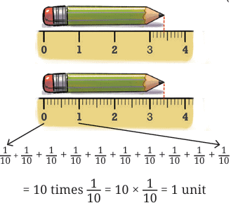
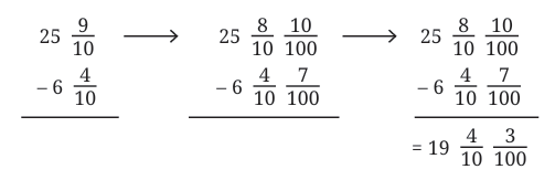
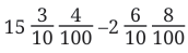
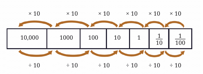 Dividing one-tenth (1/10) by 10 gives one-hundredth (1/100).
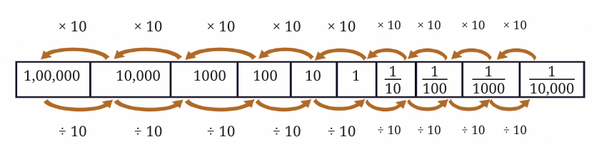 …and so on!
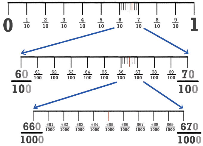

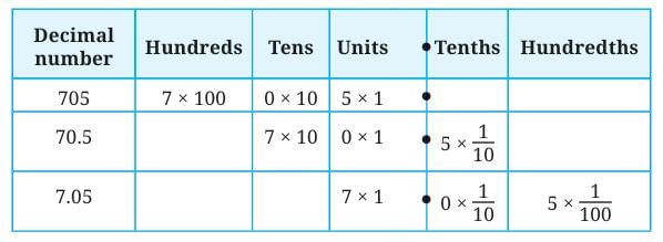
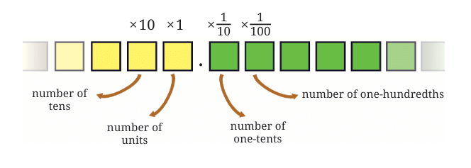 Fractional Parts (tenths, hundredths, etc.) are to the right of the decimal point.
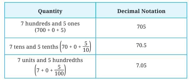
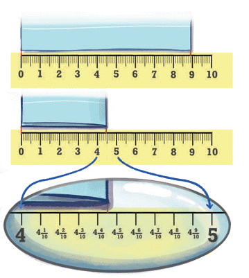
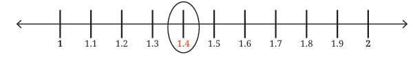 The 4th division after 1 is 1.4.
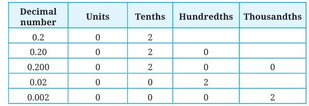

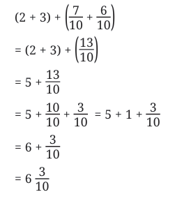
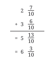
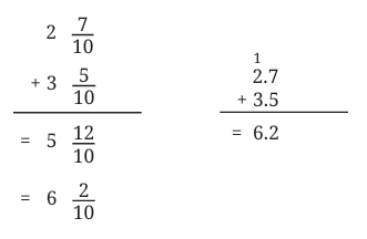 Total = 6 + 2/10 = 6.2 m
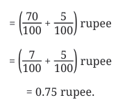
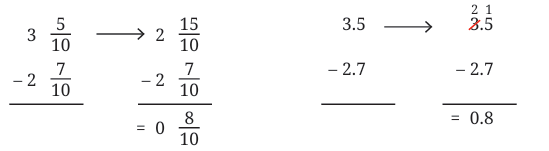 2.7 = 2 + 7/10So, difference = 8/10 = 0.8
 This could be dangerous when giving medicine.
 This shows why it’s important to know what decimals mean in real measurements.
 Some countries today use comma instead of a dot (e.g., 1,000.5 becomes 1.000,5).


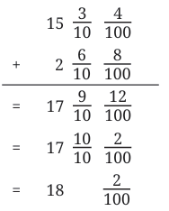
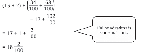
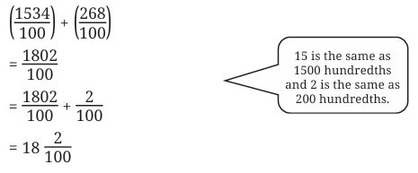
 Group the first two terms:
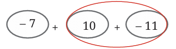 Group the last two terms:
 Wear her hat first, then her shoes, or
 Wear her shoes first, then her hat.
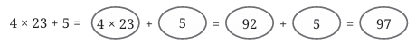
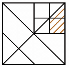
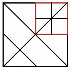
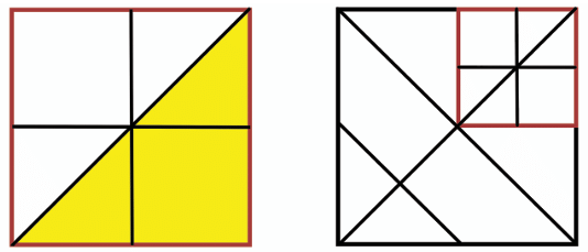
 This Image is correct