The Big Questions
Q1: What are the unique physical features of the continents?
Ans: Each continent has its own distinctive combination of landforms and water bodies:
- Asia: The Tibetan Plateau (the highest and largest plateau on Earth, also called the “Roof of the World”), the Gobi Desert, the Eurasian Steppes (an important global carbon sink), and the Ural Mountains, which form the natural boundary between Europe and Asia.
- Europe: The vast, fertile European Plain and the crescent-shaped Alps, which include peaks such as Mont Blanc and rivers such as the Rhine.
- Africa: The Sahara Desert, the largest hot desert in the world; the African Savannah, a tropical grassland rich in wildlife; and the Nile, one of the world’s longest rivers.
- South America: The Andes Mountains, which include Mount Aconcagua; the Uyuni Salt Flats; the Amazon River and Rainforest; and the extremely dry Atacama Desert.
- North America: The Colorado Plateau, including the Grand Canyon; the Rocky Mountains; the ancient Appalachian Mountains; and the Great Lakes.
- Australia: Much of the continent is covered by deserts, including the Great Victoria Desert.
These features are shaped by tectonic movement, erosion, and climate. They support unique ecosystems, provide minerals and other resources, and influence the lives of human communities.
Q2: Why do we need to understand world geography?
Ans: Understanding world geography is important because:
- It helps us understand how distant natural features are connected. For example, the Southern Indian Ocean influences the monsoon over the Gangetic Plains, and dust from the Sahara carries phosphorus to the Amazon Rainforest.
- It helps us understand how landforms, oceans, and climate shape human settlement, agriculture, trade, and culture. For example, the Suez Canal shortens the trade route from India to Europe, while river valleys such as the Nile Valley supported ancient civilisations.
- It creates awareness of the planet’s biodiversity, resources, and conservation hotspots. This encourages us to use resources responsibly.
- It helps us recognise and respond to global environmental challenges such as deforestation, coral bleaching, glacier melt, and climate change.
- It connects us to the cultural and spiritual relationships that different communities share with nature, such as India’s reverence for the Earth as Bhūdevī and indigenous communities’ respect for mountains and forests.
Q3: How do human actions trigger environmental issues?
Ans: Human actions disturb Nature’s natural balance in several ways:
- Deforestation for development destroys habitats and threatens rainforests such as the Amazon.
- Overfishing and pollution damage ocean ecosystems and contribute to coral bleaching in reefs such as the Great Barrier Reef.
- Industrialisation and burning of fossil fuels raise global temperatures. As a result, Himalayan and other glaciers melt faster than they can be replenished.
- Overgrazing, as seen with elk in Yellowstone National Park before wolves were reintroduced in 1995, can disturb the balance of an ecosystem.
- Mining and resource extraction can displace communities and damage the environment.
- Fast fashion has turned places such as the Atacama Desert into massive clothing-waste dumps. The UN has described this as an environmental and social emergency.
- Disturbance of the tundra’s permafrost due to global warming releases trapped greenhouse gases, which can further accelerate climate change.
Let’s Explore
Page No – 2
Q: What do you think each of the different colours in the map in Fig. 1.1 represents?
Ans: In physical maps, colours are used as a visual language to represent different landforms and water bodies:
- Blue represents water bodies such as oceans, seas, lakes, and rivers.
- Green represents plains.
- Yellow/Brown represents plateaus.
- Dark brown represents high mountains.
- Light yellow represents deserts.
- White represents ice and glaciers.
Think About it
Page No – 4
Q: Oceans give us almost half the oxygen we breathe. Tiny marine organisms, such as plankton, make this possible. What do you think would happen to all living beings if pollution harmed these planktons, and they could no longer produce enough oxygen?
Ans: If pollution harmed plankton populations and reduced their ability to produce oxygen, it would have severe consequences for life on Earth:
- The amount of oxygen produced in the oceans would decrease. Since plankton produce nearly half the oxygen we breathe, this could affect the balance of gases in the atmosphere.
- Marine food chains would be damaged because plankton form the base of ocean food webs. Fish, whales, and countless other sea creatures depend on them directly or indirectly.
- The ocean’s ability to absorb carbon dioxide would weaken, which could accelerate climate change.
- Reduced oxygen production and damaged food chains would eventually threaten human life as well. Humans depend on healthy oceans for oxygen, food, and climate regulation. This shows that even the smallest organisms play an important role in sustaining life on Earth.
Let’s Explore
Page No – 11
Q1: Study the map in Fig.1.11. What are the different physical features represented here? (Hint: You may refer to LET’S EXPLORE on page 2 of this chapter.)Ans: Fig. 1.11, which is a physical map of Asia, shows several physical features:
- Dark brown or mountain shading marks the Ural Mountains.
- Yellow or brown plateau shading marks the Tibetan Plateau.
- Light yellow desert shading marks the Gobi Desert.
- Green shading marks the Siberian Taiga and the Eurasian Steppes.
- Blue marks the Pacific Ocean along the eastern edge of the map. Together, these features show that Asia contains a great variety of landforms, including plateaus, deserts, grasslands, mountain ranges, and coastlines.
Page No – 15
Q2: Assess and describe the Himalayas from the perspective of these different roles.(Referring to mountains as water towers, biodiversity hotspots, and natural boundaries between countries)
Ans:
- As water towers: The Himalayas are the source of major glacier-fed rivers such as the Ganga, Indus, and Brahmaputra. These rivers provide freshwater to millions of people living in the plains and nearby regions.
- As biodiversity hotspots: The Himalayan range supports many ecosystems, from subtropical forests at lower altitudes to alpine meadows and snow-covered peaks. These ecosystems are home to unique plants and animals.
- As natural boundaries: The Himalayas form a natural boundary between India and its northern neighbours, including China and Nepal. They also influence the climate by blocking very cold winds from Central Asia.
Page No – 18
Q3: Observe the area covered by the European Plain. Now turn to the political map of the world at the end of this textbook. List the countries that are part of the European Plain (you need not memorise them).
Ans: The European Plain stretches across northern and central Europe. Countries that fall within or along the European Plain include France, Belgium, the Netherlands, Germany, Poland, Denmark, Belarus, Ukraine, and the European part of Russia, among others. Students should trace the outline shown in Fig. 1.19 on the political map at the back of the book to identify the countries accurately.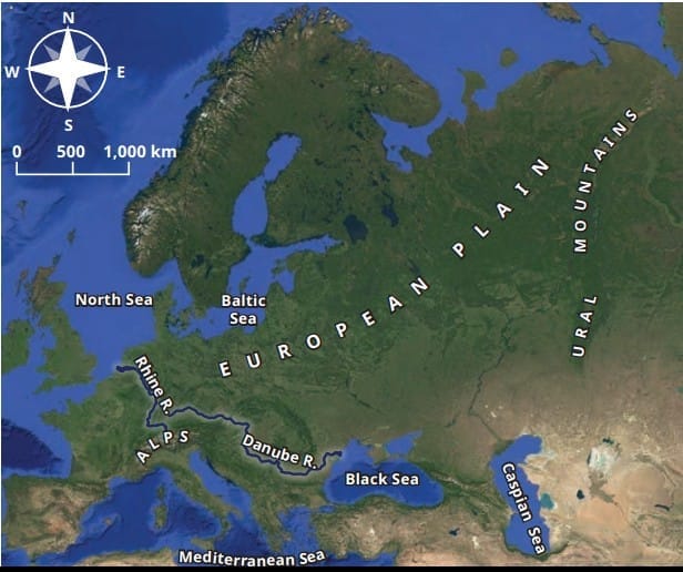
Page No – 22
Q4: On the map (Fig. 1.22) locate the course of the River Nile. Where does it originate from and in which direction does it flow? Turn to the political map at the end of the book, and identify some of the areas that the river flows through.Ans: The River Nile has two main branches. The White Nile rises in the Lake Victoria region of East Africa, while the Blue Nile begins at Lake Tana in Ethiopia. The river flows generally from south to north through Uganda, South Sudan, Sudan, and Egypt before emptying into the Mediterranean Sea. Students should trace its course on the political map at the end of the textbook.
Page No – 24
Q5: The Amazon Rainforest has been called the ‘Lungs of the Earth’. Why do you think this might be so?
Ans: The Amazon Rainforest is called the “Lungs of the Earth” because it contains a vast number of trees and plants. These plants absorb carbon dioxide and release oxygen through photosynthesis. The rainforest also stores carbon, influences rainfall, and helps regulate the Earth’s climate. Therefore, it is vital for the health of the planet.
Q6: The countries in this region need land for development but risk losing the Amazon Rainforest. Discuss in groups: What are the short and long-term effects of deforestation, and how can we protect the Amazon for the planet?
Ans: (Do it Yourself – group discussion)
- Short-term effects: Clearing land provides immediate space for agriculture, housing, and industry. It can also increase local economic activity and provide employment.
- Long-term effects: Deforestation destroys habitats, threatens the roughly 400 indigenous communities that live in and conserve the forest, reduces biodiversity, disrupts rainfall patterns, and weakens the forest’s ability to absorb carbon dioxide. This worsens climate change globally.
- Protective measures: Governments can adopt sustainable land-use policies, promote reforestation, support indigenous communities as forest stewards, enforce laws against deforestation, and spread awareness about the importance of the Amazon as a shared planetary resource.
Questions and Activities
Q1: Why do all map projections have some amount of distortion?
Ans: The Earth is an oblate spheroid, which means that it has a curved, nearly spherical shape. When we try to show this curved surface on a flat map, it is like trying to peel an orange and lay the peel completely flat without tearing it. This is not possible. Therefore, every map projection changes the shape, size, distance, direction, or position of some features to some degree. Cartographers choose different projections according to their purpose. Looking at more than one map projection gives us a fairer understanding of the world.
Q2: What makes the Tibetan Plateau unique?
Ans: The Tibetan Plateau is unique because:
- It is the highest and largest plateau on Earth, with an average height of over 4,500 metres above sea level.
- It was formed by the collision of the Indo-Australian and Eurasian tectonic plates. This collision also helped form the Himalayas.
- It stretches about 2,500 km from east to west and about 1,000 km from north to south.
- It is the source of major rivers, including the Indus, Brahmaputra, and Yangtze. It also strongly influences the climate of Asia.
- Known as the “Third Pole,” it contains large reserves of freshwater in its glaciers and lakes. However, climate change is causing its glaciers to melt and its lakes to expand.
Q3: Why are coral reefs called the ‘rainforests of the sea’?
Ans: Coral reefs are called the “rainforests of the sea” because, like tropical rainforests, they are among the most diverse ecosystems on Earth. Reefs such as the Great Barrier Reef provide food and shelter to about one-quarter of all ocean species, including fish, crabs, turtles, and sponges. Thus, they support a great variety of marine life in a relatively small area.
Q4: How do the oceans help to regulate the Earth’s climate?
Ans: Oceans help regulate the Earth’s climate by absorbing heat from the Sun and releasing it slowly. This helps to moderate temperatures. Oceans also add moisture to the air, which forms clouds and brings rainfall. Ocean currents affect the climate of coastal areas. Warm currents carry warm water from the equator towards the poles, while cold currents carry cold water towards the equator. For example, the Gulf Stream makes places such as the United Kingdom warmer than other regions at the same latitude.
Q5: What is the main reason for the Great Barrier Reef facing threats today?
Ans: The Great Barrier Reef faces serious threats mainly because of human activities such as overfishing, pollution, and climate change. Rising sea temperatures and changes in ocean conditions cause coral bleaching, in which corals lose their colour and become weak or die. This damages the habitat of many fish and other sea animals that depend on the reef.
Q6: Why is the Amazon Rainforest often called the ‘Lungs of the Earth’?
Ans: The Amazon Rainforest is called the “Lungs of the Earth” because its vast number of trees and plants absorbs large amounts of carbon dioxide and releases oxygen through photosynthesis. The rainforest also stores carbon, affects rainfall, and helps regulate the global climate. Therefore, protecting it is important not only for South America but for the entire planet.
Q7: Choose two different types of geographical features you have explored in this chapter. Write short paragraphs on how they influence the flora and fauna or human lives in that area. Do they also have an implication for the whole globe?
Ans:
- The Sahara Desert: This vast hot desert has high temperatures and very little rainfall. It supports specially adapted plants and animals such as date palms, cacti, and the fennec fox. It has shaped the lives of nomadic communities that herd sheep, goats, and camels. It also supported old trade routes carrying gold and salt. Dust from the Sahara travels to the Amazon Rainforest and carries phosphorus that helps nourish rainforest plants. This shows how a desert can influence life on another continent.
- The Andes Mountains: The Andes are an important source of freshwater and feed the Amazon River. They support rich biodiversity, although much of the original flora and fauna has been lost. The mountains are also rich in resources such as copper, zinc, silver, and lithium. These resources support local economies and are important for industries around the world.
Q8: Discuss how oceans influence climate and trade. Use examples from the Indian and Pacific Oceans.
Ans:
- Climate: Oceans absorb and release heat slowly, which moderates temperatures. They also add moisture to the air, forming clouds and bringing rainfall. The warm waters of the Indian Ocean influence monsoon patterns that affect agriculture across South Asia. The vast Pacific Ocean also plays a major role in global weather and climate systems.
- Trade: The Indian Ocean has connected India, Africa, the Middle East, and Southeast Asia through trade for centuries. The Pacific Ocean is also an important route for global trade and transport, connecting the major economies of Asia and the Americas. The Suez Canal connects the Indian Ocean with Europe through the Red Sea and the Mediterranean Sea. Thus, both oceans are important for world commerce.
Q9: Choose one environmental issue (deforestation, reef bleaching, or desertification) and explain its causes, impacts, and possible solutions.
Ans: (Sample answer – Deforestation)
- Causes: Forests are cut down faster than they can regrow, often to clear land for agriculture, housing, roads, or industry. This can be seen in parts of the Amazon Rainforest.
- Impacts: Deforestation causes the loss of habitats for wildlife and indigenous communities. It reduces biodiversity, disturbs rainfall patterns, and weakens the ability of forests to absorb carbon dioxide. As a result, it can worsen climate change.
- Solutions: Governments should promote sustainable land use, reforestation, and afforestation. They should protect indigenous communities that act as forest stewards, enforce laws against illegal logging, and encourage global cooperation and awareness about the importance of forests such as the Amazon.
Q10: Imagine you are a geographer asked to advise a government about protecting one major landscape in your country. Which one would you choose, and why?
Ans: (Do it Yourself – sample answer) I would choose to protect the Himalayan region in India. The Himalayas act as a vital “water tower” because they feed major rivers such as the Ganga, Indus, and Brahmaputra. Millions of people depend on these rivers for drinking water, irrigation, and other needs. The Himalayas are also a biodiversity hotspot with unique plants and animals. Since their glaciers are melting because of climate change, the region needs special protection. Sustainable tourism, controlled construction, afforestation, and regular monitoring of glaciers can help protect its water resources and biodiversity for future generations.
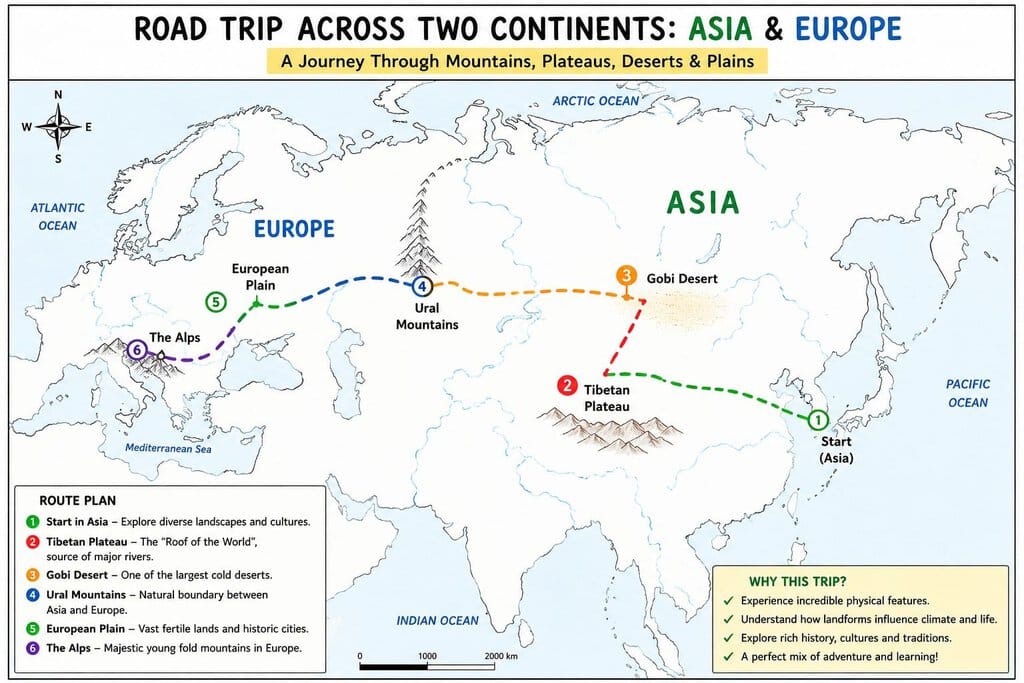
Q11: Imagine that someone is funding a group of you for a road trip across two continents. There are differences of opinion on which two they should be. Make a pitch for the ones you would like everyone to go to. Use a blank map, trace your route and locate the places on it, and try to convince the others to your point of view. You could use a variety of creative ways.
Ans: Students should choose two continents covered in the chapter, such as Asia and Europe. They can trace a route on a blank map connecting important landmarks studied in the chapter, such as the Tibetan Plateau, Gobi Desert, Ural Mountains, European Plain, and the Alps. They should prepare a short creative pitch in the form of a poster, presentation, or story. The pitch should explain why these places would make the road trip exciting and educational, using facts learnt in the chapter to support their choice.